Past Projects
This page provides details of selected past projects managed by or prominently featuring staff from the Swiss Seismological Service (SED). The list is not exhaustive; it merely covers selected key or large-scale projects. The projects are grouped together according to the main focus of their research.
Cross-disciplinary projects
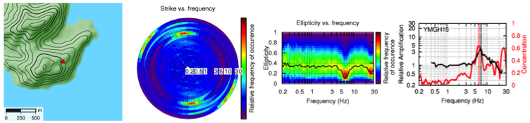
Characterization of Unstable Rock Slopes Through Passive Seismic Measurements
|
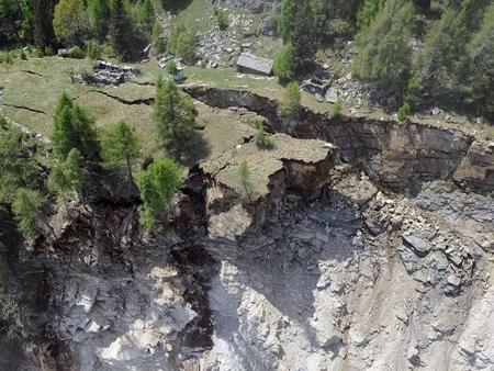
In this ETHZ-funded project we analyze ambient vibration and earthquake recordings to characterize and investigate the dynamic response of unstable rock slopes. We perform systematic measurements and interpretation of ambient vibrations at known unstable rock slopes, both with single stations and array-configurations. The eigenfrequencies, eigenmodes, directivity, and amplification of ambient vibrations are identified and compared to geotechnical investigations. The interpretation of recordings targets the estimation of the potential landslide volume and is supported by numerical modeling of seismic wave propagation in fractured media. A classification scheme based on the seismic response has been introduced. Each class indicates specific properties of a rock instability. The two main classes found are the volume-controlled sites and the depth-controlled sites. The extensive database will be extended with instabilities on high-alpine permafrost locations. Moreover, both short-term and long-term monitoring is undertaken to understand the time evolution of the slope structure. Short-term monitoring is performed at the Alpe di Roscioro (Preonzo) site which represents a unique opportunity to monitor a slope close to collapse. A second semi-permanent station will be installed on the large rock instability above Brienz (Grisons). A main goal of the monitoring is to understand the effect of weather and climate on the dynamic behavior of the rock and its stability. Long-term monitoring is based on the analysis of available past recordings from existing seismic networks, especially for stations located at or very close to steep cliffs. In a later stage of the project, the effect of earthquakes on the rock slope stability will be evaluated using numerical modelling. It will be evaluated, if ambient noise measurements can provide a direct proxy for the seismic vulnerability of rock slope instabilities. The expected results have the potential to be applied directly in hazard analysis and risk reduction measures. |
|---|---|
| Project Leader at SED | Prof. Donat Fäh |
| SED Project Members | Mauro Häusler, Ulrike Kleinbrod |
| Funding Source | ETHZ |
| Duration | 2013 - 2021 |
| Keywords | unstable rock slopes, ambient vibrations, ground motion modelling |
| Research Field | Seismic hazard, earthquake induced effects, engineering seismology |
| Publications |
|
ENVRIplus: Environmental Research Infrastructures Providing Shared Solutions for Science and Society
ENVRIplus is a Horizon 2020 project bringing together Environmental and Earth System Research Infrastructures, projects and networks as well as technical specialist partners to create a more coherent, interdisciplinary and interoperable cluster of Environmental Research Infrastructures across Europe. The project has 37 partners from 13 countries, representing 27 European Research Infrastructures. Environmental Research Infrastructures provide key tools and instruments for researchers to address specific challenges within their own scientific fields. However, to tackle the grand challenges facing human society (for example climate change, extreme events, loss of biodiversity, etc.), scientific collaboration across the traditional fields is necessary. The Earth system is highly interlinked and the area of focus for environmental research is therefore our whole planet. Collaboration within ENVRIplus will enable multidisciplinary Earth system science across the traditional scientific fields, which is so important in order to address today’s global challenges. The cooperation will avoid the fragmentation and duplication of efforts, making the Research Infrastructures’ products and solutions easier to use with each other, improving their innovation potential and the cost/benefit ratio of the Research Infrastructure operations. ENVRIplus is organized in 6 overarching themes. SED leads the workpackage 'A Framework for Environmental Literacy' in Theme 4 'Societal Relevance and Understanding', and participates in the WP 'Developing an Ethical Framework for Research Infrastructures' in that Theme. We also participates in various workpackages and activities in Theme 2 'Data for Science' and Theme 3 'Access to Research Infrastructures'. |
|
| Project Leader at SED | Florian Haslinger |
|---|---|
| SED Project Members | Michèle Marti, Carlo Cauzzi, Philipp Kästli, Marcus Herrmann. Former staff: Jeremy Zechar, Isabell Schlerkmann |
| Funding Source | SBFI (for EU Horizon2020) |
| Duration | May 2015 – April 2019 |
| Keywords | Environmental Research, Earth System Research, Infrastructure, Earth System science |
| Research Field | Earth System Science |
| Link To Project Website | |
EPOS-IP: European Plate Observing System – Implementation Phase
The European Plate Observing System (EPOS [www.epos-eu.org]) is a single, sustainable, permanent research infrastructure for solid Earth sciences in Europe. EPOS integrates existing geophysical monitoring networks (e.g. seismic and geodetic networks), local observatories (e.g. volcano observatories) and experimental laboratories (e.g., experimental and analytic lab for rock physics and tectonic analogue modeling) across Europe and adjacent regions to form a federated, coherent multidisciplinary infrastructure. The EPOS components provide key parameters for the multidisciplinary study of the interior structure, composition and dynamics of the Earth, for exploration activities related to the identification and exploitation of natural and energy resources and for the assessment and monitoring of natural hazards. In addition to Earth scientists, users of EPOS data include engineers and private practitioners, public offices, construction industry and critical infrastructures, and the (re)insurance sector. EPOS-IP is an EU Horizon 2020 project supporting the implementation of EPOS. This project brings together 47 consortium members and 6 associate partners from 25 countries, covering all involved scientific domains as well as coordinated IT developments and legal and financial aspects in the preparation for the establishment of EPOS as a European Research Infrastructure Consortium (ERIC) by late 2018. The SED and the professorship of Seismology and Geodynamics at ETH Zürich have been playing a leading role in the development of EPOS since its conception in the early 2000s. In EPOS-IP, SED coordinates the build-up of the Thematic Core Service (TCS) Seismology [https://www.epos-ip.org/tcs/seismology], and is strongly involved in the TCS Near-Fault Observatories [https://www.epos-ip.org/tcs/near-fault-observatories], where we contribute the monitoring infrastructure operated by the SED in the Valais. As one of the services in the TCS Seismology, SED hosts the coordinated European Seismic Hazard and Risk platform EFEHR. |
|
| Project Leader at SED | Florian Haslinger |
|---|---|
| SED Project Members | Main contributors: Stefan Wiemer, John Clinton, Philipp Kästli, Laurentiu Danciu |
| Funding Source | EU Horizon2020 |
| Duration | October 2015 – September 2019 |
| Keywords | Solid Earth, seismological data, products, services, ERIC |
| Research Field | Earthquakes, Earth Structure Earthquake Hazard & Risk, Historical Seismicity, Seismotectonics, Real-time monitoring, Engineering Seismology, Solid Earth Sciences |
| Link To Project Website | |
InSight - Mission to Mars: The Marsquake Service at SED
|
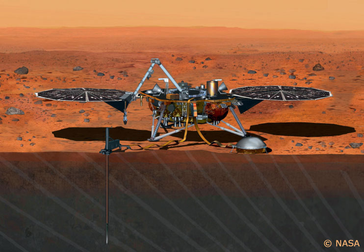
InSight (Interior exploration using Seismic Investigations, Geodesy and Heat Transport) is a NASA Discovery Program mission that will deploy a single geophysical lander on Mars to study its deep interior. This is the first comprehensive surface-based geophysical investigation of Mars. The overarching mission goals are to illuminate the fundamentals of formation and evolution of terrestrial (Earth-like) planets by investigating the interior structure and processes of Mars, and more specifically to determine the thickness, structure and composition of the crust, mantle and core, and to measure the rate and distribution of seismic activity and the rate of meteorite impacts. The Mission should land in November 2018 and have a lifetime of about two Earth years. A set of 3-component broadband and short period seismometers (collectively known as SEIS) will be deployed beside the lander. In additional, InSight will also deploy a heat flow probe (HP3), a geodetic experiment (RISE), a magnetometer, and meteorological sensors. Seismological investigations of Mars have so far been based on modeling and synthetic data; starting in 2018, waveform data will be returned from Mars and the era of 'Seismology on Mars' will begin. Building on our expertise and infrastructure for earthquake monitoring and seismic data processing on Earth, the SED will take the lead role in the building a catalogue of seismic events recorded by SEIS (the 'Marsquake Service’). This service will comprise automatic and reviewed event detection and characterization of local and teleseismic events, as well as meteor impacts. The goal of this service is to provide a comprehensive high-quality event catalogue for Mars that is critical to the SEIS project, in particular as input to the development of Martian crustal and deep structure models. We are adapting advanced single-seismometer analysis techniques developed on the Earth to provide locations for Martian seismicity. Creating the Marsquake Service is a collaboration between the SED and the SEG groups at the ETH Zurich. |
|---|---|
| Project Leader at SED | Prof. Domenico Giardini (InSight Co-I) |
| SED Project Members | Dr. John Clinton (Seismic Network Manager, InSight Co-I) Dr. Amir Khan (Affiliated Scientist) Dr. Martin van Driel (PostDoc) Dr. Maren Böse (Project Scientist) Dr. Fabian Euchner (PostDoc) Dr. Savas Ceylan (IT Specialist) |
| Funding Source | SNF / SSO |
| Duration | 2015 - 2018 |
| Keywords | Planetary seismology, Mars, InSight, single-station approaches, seismic monitoring |
| Research Field | |
| Link To Project Website |
RISE: Real-time earthquake rIsk reduction for a reSilient Europe
|
|
RISE (Real-time earthquake rIsk reduction for a reSilient Europe) was a four-year project funded by the Horizon 2020 programme of the European Commission. It started in September 2019 and concluded in May 2023. Coordinated by ETH Zurich, RISE brought together 19 organisations from eight different European countries and five international partners.
Seismic risk is not constant. It varies in time, location, and context. For example, a recent earthquake of a certain magnitude increases for a specific period the chances for another big event to follow. In addition, the vulnerability of structures, soil conditions, and individual behaviour influence the consequences of an earthquake. Dynamic risk describes the interplay of these aspects. The primary objective of RISE was to revolutionise the way in which earthquake risk is perceived and managed by leveraging scientific and technological advancements. The vision of RISE was to move beyond the traditional static concept of earthquake hazard and risk, to a dynamic and evolving one that is influenced by multiple factors, such as location, soil conditions, topography, structural type, occupancy, and seismic activity.
To achieve its objectives, RISE adopted an integrative, holistic view of risk reduction targeting the different stages of risk management by a multidisciplinary approach that focuses on Operational Earthquake Forecasting, Earthquake Early Warning, Rapid Loss Assessment and Recovery, and Rebuilding Efforts. The project involved earth scientists, engineering scientists, computer scientists, and social scientists. Their collective efforts significantly advanced Europe's real-time seismic risk reduction capabilities and established a new paradigm of dynamic risk. RISE has developed and validated the next generation of forecasting models, which have improved short-term and operational earthquake forecasting.
Collaboration with various research groups across Europe ensured the quality of earthquake prediction and forecasting through validation and rigorous testing. Additionally, RISE has contributed to the establishment of sound and rational risk reduction procedures and has enhanced the preparedness of societies, emergency managers, and long-term recovery management in order to minimize the negative impact of future earthquakes and promote a more resilient Europe. |
|---|---|
| Project Leader at SED | Prof. Stefan Wiemer |
| Funding Source | Horizon 2020 |
| Duration | 2019 - 2023 |
| Keywords | risk reduction, earthquake forecasting, seismology, civil engineering, geohazards, seismic risk, big data |
| Research Field | Monitoring, Alerting and Analysis, Earthquake Hazard and Risk, Earthquake Processes, Communication |
| Link To Project Website | |
| Publications |
SERA: Seismology and Earthquake Engineering Research Infrastructure Alliance for Europe
|
|
The "Seismology and Earthquake Engineering Research Infrastructure Alliance for Europe" (SERA) aims to reduce the risk posed by natural and anthropogenic earthquakes. SERA will significantly improve the access to data, services and research infrastructures, and deliver solutions based on innovative research and development projects in seismology and earthquake engineering. SERA is a Horizon 2020-supported programme responding to the priorities identified in the call INFRAIA-01-2016-2017 “Research Infrastructure for Earthquake Hazard”. SERA involves 31 partners and 8 linked third parties in Europe. To reach its objectives, SERA will…
These efforts will lead to a revised European Seismic Hazard reference model for consideration in the ongoing revision of the Eurocode 8 and to a first, comprehensive framework for seismic risk modeling at European scale. SERA will further develop new standards for future experimental observations in earthquake engineering, for the design of instruments and networks for observational seismology, and reliable methodologies for real-time assessment of shaking and damage. By expanding the access to seismological observations and assisting in connecting infrastructures and communities in the fields of deep seismic sounding, experimental earthquake engineering and site characterization SERA facilities collaboration and innovations in the respective areas. SERA will also contribute meaningfully to the construction and validation of EPOS and effectively communicate its activities and achievements to the relevant stakeholders. |
|---|---|
| Project Leader at SED | Prof. Stefan Wiemer |
| SED Project Members | Dr. Florian Haslinger, Dr. Laurentiu Danciu, Michèle Marti, Stephanie Schnydrig, Dr. Francesco Grigoli |
| Funding Source | SBFI |
| Duration | 2017 - 2020 |
| Keywords | seismology, earthquake engineering, seismic hazard and risk, anthropogenic seismicity, deep underground, earth structure, georesources, geohazards |
| Research Field | Seismic Hazard and Risk, Earthquake Engineering, Operational Earthquake Forecasting, Induced Seismicity |
| Link To Project Website |
Fields of Research

Seismic Hazard Assessment
Basel Erdbebenvorsorge: Earthquake Risk Mitigation for the City of Basel
|
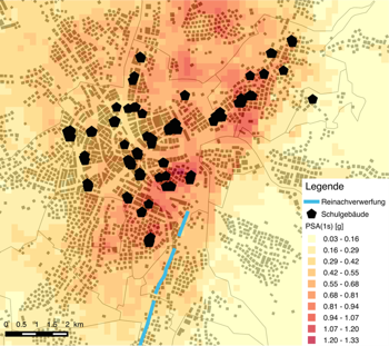
Following the seismic microzonation of Basel, the project «Basel Erdbebenvorsorge» was funded by the canton Basel-Stadt. It aimed first at improving the seismic network in Basel and collecting data for the next generation of microzonation studies, and second at proposing earthquake scenarios and risk computations for all cantonal school buildings. This study sets the framework for studies including the whole city, supporting earthquake mitigation and crisis management. In a first phase, 6 new modern strong-motion stations have been installed, complementing the installations from the SSMNet renewal project. The sites have been characterized through geophysical measurements. In addition, 5 temporary stations have been installed for the period of the project. In a second phase, a new amplification map was developed accounting for all information collected for the completed microzonation study and more recent data. The third phase was the development of a risk framework using the Openquake software. The company Resonance Ingénieurs-Conseils performed the assessment of the capacity curves of the school buildings, that were implemented through fragility curves. A particular focus of the project was put on the uncertainties of the risk-calculation process. Scenarios for typical events of the area were assessed, based on the historical seismicity and the de-aggregation of the regional seismic hazard. The effect of retrofitting of the school-building stock through the ongoing HARMOS project was quantified with a cost-benefit analysis. |
|---|---|
| Project Leader at SED | Donat Fäh |
| SED Project Members | Clotaire Michel |
| Funding Source | Kanton Basel-Stadt |
| Duration | 2013-2016 |
| Keywords | Seismic risk, seismic vulnerability, microzonation, school buildings, site effects, Openquake, strong motion |
| Research Field | Earthquake Hazard & Risk, Engineering Seismology |
| Publications |
Michel, C., Hannewald, P., Lestuzzi, P., Fäh, D., & Husen, S. (2017). Probabilistic mechanics-based loss scenarios for school buildings in Basel (Switzerland). Bulletin of Earthquake Engineering 15(4), 1471–1496. doi: 10.1007/s10518-016-0025-2 Michel, C., Fäh, D., Edwards, B., & Cauzzi, C. (2017). Site amplification at the city scale in Basel (Switzerland) from geophysical site characterization and spectral modelling of recorded earthquakes. Physics and Chemistry of the Earth, Parts A/B/C 98, 27-40. doi: 10.1016/j.pce.2016.07.005 Michel C., Fäh D. (2016). Basel earthquake risk mitigation - Computation of scenarios for school buildings. Technical Report. Zürich, Switzerland: ETH-Zürich. doi: 10.3929/ethz-a-010646514 Michel C., Fäh D., Edwards B., Cauzzi C. (2016, in press). Site amplification at the city scale in Basel (Switzerland) from geophysical site characterization and spectral modelling of recorded earthquakes. Physics and Chemistry of the Earth Special Issue “Advances in seismic site response: standard-practice and innovative methods”. doi: 10.1016/j.pce.2016.07.005 Michel, C., Fäh, D., Lestuzzi, P., Hannewald, P. and Husen, S. (2015). Detaillierte Erdbeben-Schaden-szenarien für die Schulgebäude im Kanton Basel-Stadt. Dokumentation SIA D 0255 Erdbeben und bestehenden Bauten, 14. D-A-CH-Tagung, Zürich. Michel C., Hannewald P., Lestuzzi P., Fäh D., Husen S. (2016, in press). Probabilistic mechanics-based loss scenarios for school buildings in Basel (Switzerland). Bulletin of Earthquake Engineering. doi: 10.1007/s10518-016-0025-2 Résonance (2016). Basel earthquake risk mitigation – Capacity curves of school buildings. Technical Report. Zürich, Switzerland: ETH-Zürich. doi: 10.3929/ethz-a-010647300 |
3D-ASEMB: Analysis of Site Effects Using 3-D Models for the Area of Bucharest City
|
The objective of this project is the microzonation of the Bucharest city (Romania). For a better understanding of the geological structure under Bucharest, non-invasive methods are used, as: wavelet-polarization analysis at each station, H/V for ambient vibrations and earthquakes, and the three-components array analysis of ambient vibration recordings from URS experiment, in order to retrieve the characteristics of surface waves. Surface wave dispersion curves, their ellipticity and the data from boreholes (depth < 100m) are jointly inverted to estimate the velocity structure under the city. The final 3D structure will be used for the numerical simulation of the seismic waves propagation from the Vrancea intermediate-depth source to the city in order to investigate the seismic hazard in the city. Data used in this project are from: National Institute of Earth Physics, CRC461-Proiect URS – URban Seismology 2003-2004, BIGSEES ”BrIdging the Gap between Seismology and Earthquake Engineering: from the Seismicity of Romania towards a refined implementation of seismic action EN1998-1 in earthquake resistant design of buildings” |
|---|---|
| Project Leader at SED | Donat Fäh |
| SED Project Members | Elena Manea, Clotaire Michel, Manuel Hobiger, Valerio Poggi |
| Funding Source | Sciex-NMSch Programme, No. 13.123 |
| Duration | 2014-2015 |
| Keywords | Ambient Vibration, Array Processing, 3D Geophysical Model, Seismic Hazard |
| Research Field | Earthquake Hazard & Risk, Engineering Seismology |
| Publications |
Manea, E.F, Michel C., Poggi V., Fäh D., Radulian M., Bălan S.F. (2016). Improvement of the shear wave velocity structure beneath Bucharest (Romania) using ambient vibrations. Geophysical Journal International, under review. Manea, E.F., Michel C., Hobiger M., Fäh D., Cioflan C.O., Radulian M. (2016). Analysis of the seismic wave field in the Moesian Platform (Bucharest area) for hazard assessment purposes. In preparation. |
| Presentations |
Manea E. F., Hobiger M., Michel C., Fäh D., Cioflan C. O. (2016). Analysis of the seismic wavefield in the Moesian Platform (Bucharest area). Geophysical Research Abstracts Vol. 18, EGU 2016, 930. Access for SSA members only Manea E. F., Michel C., Fäh D., Poggi V., Edwards B., Cioflan C. O., Radulian M., Balan S. F. (2015). Improvement of the Shear Wave Velocity Structure Beneath Bucharest (Romania) Using Non-Invasive Techniques. Seismological Society of America (SSA 2015) Annual Meeting, Pasadena, California, 21-23 April 2015. Access for SSA members only |
NERA: Network of European Research Infrastructures for Earthquake Risk Assessment and Mitigation
|
NERA was a project in the Seventh Framework Program (FP7) of the European Commission (EC) that integrated key research infrastructures in Europe to monitor earthquakes and assess their hazard and risk to improve and make a long-term impact on the assessment and the reduction of the vulnerability of constructions and citizens to earthquakes. Our group was involved in the Work package JRA1, Waveform modelling and site coefficients for basin response and topography, and Workpackage NA5, Networking near-fault observatories. The key objective of JRA1 was to establish some scientifically solid and practically acceptable propositions to incorporate basin and surface topography effects in seismic design (building codes, microzonation studies, critical facilities). We contributed with a systematic study of the topographic site effects with emphasis on reasonable characterization of the both topographic site structures and observed effects on ground motion. We gathered available earthquake and ambient vibration recordings from sites with pronounced topography (Europe, Japan) and performed joint analysis with digital elevation models. The results and final recommendations have been published in a report. These conclusions contribute to the ongoing (light) revision of EC8. The objective of NA5 was to collaborate in sharing of technological and scientific experience and know-how between the near-fault observatories. We shared our experience with the installation (including data gathering and data archiving) of various instruments in the Valais region. This workpackage represented an infrastructural support for workpackage 2 of the project REAKT. |
|---|---|
| Project Leader at SED | Donat Fäh |
| SED Project Members | Jan Burjanek |
| Funding Source | EC |
| Duration | 2010-2014 |
| Keywords | Topography, site-effects, near-fault observatories |
| Research Field | |
| Publications |
Burjanek, J., Edwards, B. and Fäh, D. (2013). Empirical evidence of topographic site effects: a systematic approach. Geophys. J. Int. 197, 608-619. doi: 10.1093/gji/ggu014 |
| Reports / Deliverables |
PRP PEGASOS Refinement Project
In the 1990s the Swiss Federal Nuclear Safety Inspectorate (HSK) identified the need to update the seismic hazard assessments for Swiss NPPs and in 1998 asked the Swiss NPP operators to draw up a new hazard study that would comply with SSHAC level 4 (SSHAC, 1997) requirements. Nagra (the National Co-operative for the Disposal of Radioactive Wastes) was commissioned to plan, organize and perform such a study – the PEGASOS project (Probabilistische Erdbeben-Gefährdungs-Analyse für KKW-Standorte in der Schweiz). The project involved more than 20 experts from seven European countries, with support provided by 25 Swiss and foreign specialists and consultants. The project was completed in the summer of 2004. In 2008 the "PEGASOS Refinement Project" was launched in order to address potential refinements. As part of this project the SED was commissioned to provide input and to develop specific products:
Finite-fault near-source broadband ground-motion simulation |
|
| Project Leader at SED | Donat Fäh |
|---|---|
| Funding Source | |
| Duration | 2008-2013 |
| Keywords | Earthquake catalogues, earthquake sources, ground motion prediction equations, numerical ground-motion simulations |
| Research Field | Seismic hazard assessment |
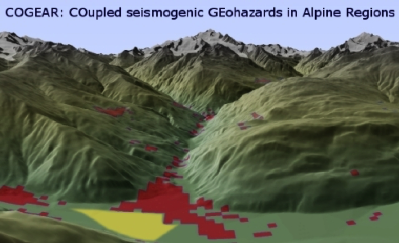
COGEAR: Coupled Seismogenic Geohazards in Alpine Regions
|
COGEAR was an interdisciplinary natural hazards project investigating the hazard chain induced by earthquakes. It addressed tectonic processes and the related variability of seismicity in space and time, earthquake forecasting and short-term precursors, and strong ground motion as a result of source and complex path effects. We studied non-linear wave propagation phenomena, liquefaction and triggering of landslides in soils and rocks, as well as earthquake-induced snow avalanches. The Valais, and in particular parts of the Rhone, Visper and Matter valleys have been selected as study areas. Tasks included detailed field investigations, development and application of numerical modelling techniques, assessment of the susceptibility to seismically induced effects and installation of different monitoring systems to test and validate our models. These systems are for long-term operation and include a continuous GPS and seismic networks, a test installation for observing earthquake precursors, and a system to study site-effects and non-linear phenomena in two test areas (Visp, St. Niklaus-Randa). Risk-related aspects of impacts on buildings and lifelines were also considered. COGEAR was supported by the Competence Center for Environment and Sustainability (CCES) of ETH Zurich. |
|---|---|
| Project Leader at SED | Donat Fäh |
| Funding Source | Competence Center for Environment and Sustainability (CCES) of ETH Zurich |
| Duration | 2008-2012 |
| Keywords | seismic ground motion, non-linear phenomena, landslides, earthquake precursors, earthquake forecasting, Switzerland. |
| Research Field | |
| Link To Project Website |
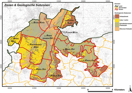
Basel Microzonation
|
For the city of Basel, a qualitative microzonation was performed in 1997. The zonation was mainly based mainly on the properties of the quaternary sediments. This triggered a study that provided a quantitative assessment of ground motion amplification in order to determine which levels of amplifications have to be taken into account a site-specific hazard assessment in the Basel area. It is the result of two large projects, the ETH project “Earthquake scenarios for Switzerland” (1997-2002) and the INTERREG project “Seismic Microzonation in the upper Rhine Graben area” (2003-2006) (Fäh end Huggenberger, 2006). Earthquakes in the Basel region triggered the strong motion network in Basel and provided a data set for comparison. Spectral ratios from recordings confirm the results of the microzonation study. Finally uniform hazard spectra were derived for each zone by combining the hazard on rock with the amplification functions. The microzonation is published on the Internet: Basel Landschaft: http://geoview.bl.ch Basel Stadt: www.geo.bs.ch/erdbebenmikrozonierung |
|---|---|
| Project Leader at SED | Donat Fäh |
| SED Project Members | Hans Havenith, Ivo Oprsal, Brian Steiner, Sybille Steimen, Philipp Kästli, Gabriela Stamm, Johannes Ripperger, Jan Burjanek |
| Funding Source | Interreg, Kantone Basel Stadt & Basel Landschaft |
| Duration | 2003-2009 |
| Keywords | Microzonation, Basel |
| Research Field | Earthquake Hazard & Risk, Engineering Seismology, Microzonation |
| Publications |
Fäh, D. and P. Huggenberger (2006). INTERREG III, Erdbebenmikrozonierung am südlichen Oberrhein. Zusammenfassung für das Projektgebiet Gebiet in der Schweiz. CD and Report (in german; available from the authors). Fäh, D. and T. Wenk (2009). Mikrozonierung für die Kantone Basel Stadt und Basel Landschaft: Optimierung der Form der Antwortspektren und der Anzahl der Mikrozonen. In: Schweizerischer Erdbebendienst ETH Zürich: Abschlussbericht: Teilbericht B Projekt "Umsetzung der Mikrozonierung in den Kantonen Basel Stadt und Basel Landschaft". Fäh, D., Steimen, S., Oprsal, I., Ripperger, J., Wössner, J., Schatzmann, R., Kästli, P., Spottke, I. and P. Huggenberger (2006). The earthquake of 250 A.D. in Augusta Raurica, a real event with a 3D site-effect?. Journal of Seismology 10, 459-477. Fäh, D., Gisler, M., Jaggi, B., Kästli, P., Lutz, T., Masciadri, V., Matt, C. Mayer-Rosa, D., Rippmann, D., Schwarz-Zanetti, G., Tauber, J., Wenk, T. (2009). The 1356 Basel earthquake: an interdisciplinary revision. Geophys. J. Int. 178, 351-374. Fäh, D. Ripperger, J., Stamm, G., Kästli, P., and J. Burjanek (2009). Mikrozonierung für die Kantone Basel Stadt und Basel Landschaft: Validierung und Umsetzung der Mikrozonierung (2006-2008). In: Schweizerischer Erdbebendienst ETH Zürich: Abschlussbericht: Teilbericht A Projekt "Umsetzung der Mikrozonierung in den Kantonen Basel Stadt und Basel Landschaft". Havenith, H.-B., Fäh, D., Polom, U. and A. Roulle (2007). S-wave velocity measurements applied to the seismic microzonation of Basel, Upper Rhine Graben. Geophys. J. Int. 170, 346-358. Kind, F. (2002). Development of microzonation methods: application to Basel, Switzerland. Ph.D. thesis, ETH Zürich, Available in electronic form from www.ethbib.ethz.ch. Kind, F., Fäh, d., & Giardini, D. (2005). Array measurements of s-wave velocities from ambient vibrations. Geophysical Journal International 160, 114-126. Meghraoui, M., Delouis, B., Ferry, M., Giardini, D., Huggenberger, P., Spottke, I., & Granet, M. (2001). Active normal faulting in the Upper Rhine Graben and paleoseismic identification of the 1356 Basel Earthquake. Science 293, 2070-2073. Noack, T. (1993). Geologische Datenbank der Region Basel. Eclogae geol. Helv. 86, 283-301. Noack, T., Kruspan, P., Fäh, D., & Rüttener, E. (1999). Mikrozonierung von Basel-Stadt. Geologischer Bericht Nr. 24, Landeshydrologie und -Geologie Schweiz. Oprsal, I., Fäh, D., Mai, M. and D. Giardini (2005). Deterministic earthquake scenario for the Basel area - Simulating strong motion and site effects for Basel, Switzerland. J. Geophys. Res. 110, B04305. doi: 10.1029/2004JB003188 Oprsal, I., Fäh, D. (2007). 1D vs 3D strong ground motion hybrid modelling of site, and pronounced topography effects at Augusta Raurica, Switzerland - Earthquakes or battles? . 4th International Conference on Earthquake Geotechnical Engineering, June 25-28, 2007, Paper No. 1416. Ripperger, J., Kästli, P., Fäh, D., Giardini, D. (2009). Ground motion and macro-seismic intensities of a seismic event related to geothermal reservoir stimulation below the city of Basel - observations and modelling. Geophysical J. Int. 179, 1757–1771. Zechner, E., Kind, F., Fäh, D., & Huggenberger, P. (2001). 3-D Geological model of the Southern Rhine Graben compiled on existing geological data and geo-physical reference modeling. Abstract Volume of the 2nd EUCOR-URGENT Workshop, 7.-11. October, Mont Saint-Odile, Strasbourg, France, p. 43. |
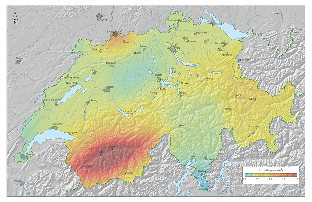
Seismic Hazard Switzerland 2004
|
Earthquakes are a serious threat to society and human beings. In order to implement measures to mitigate the consequences of earthquakes, the seismic hazard needs to be well assessed and known. Seismic hazard is defined as the probable level of ground shaking associated with the recurrence of earthquakes in a given time period. The assessment of seismic hazard is the first step in the evaluation of seismic risk. Seismic hazard is assessed by combining the history of past earthquakes with the knowledge of the present seismotectonic setting and the local properties of the waves generated by earthquakes. We present the results of the 2004 generation of probabilistic seismic hazard assessment for Switzerland. This study replaces the previous intensity based generation of hazard maps from 1976. It is the first to systematically consider alleatory and epistic uncertainties and compute spectral hazard. |
|---|---|
| Project Leader at SED | |
| Funding Source | |
| Duration | |
| Keywords | Seismic Hazard |
| Research Field | Seismic Hazard |
| Link To Project Website |
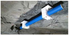
Lake Tsunamis: Causes, Consequences and Hazard
|
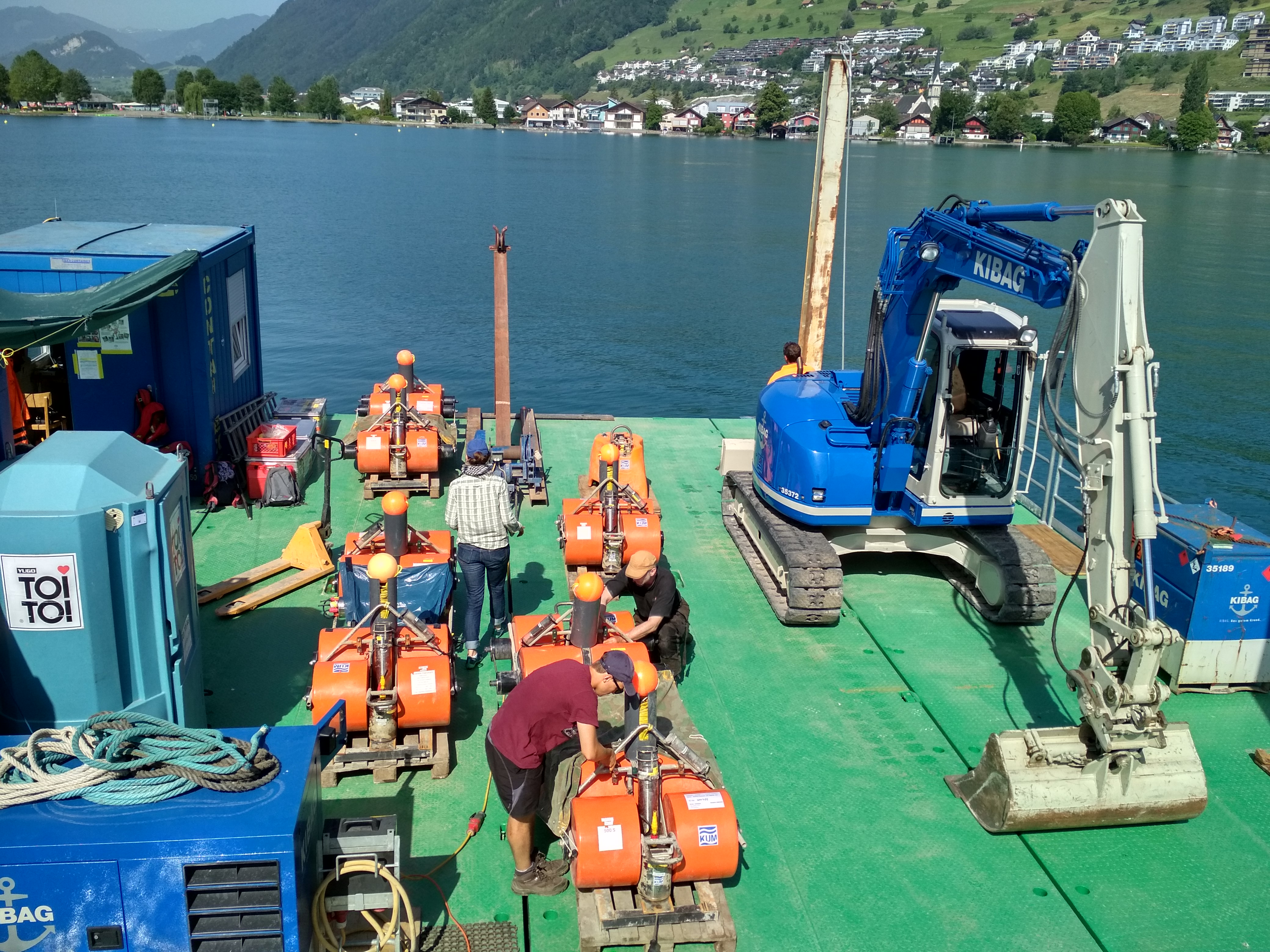
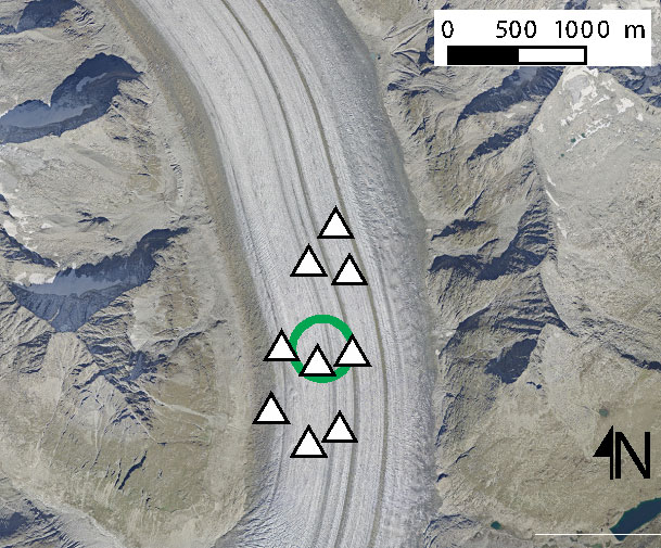
Tsunamis do not only happen in oceans, but they do also occur in lakes. This project aims to understand the trigger mechanisms, preconditions, processes and impacts of lake tsunamis within an interdisciplinary environment (limnogeologists, seismologists, geotechnical specialists, hydraulic engineers and hazard specialists). Two Work Packages of this project (WPresponse and WPhazard/ Tsunami-CH) are conducted at SED. WPresponse aims to characterize the sediment-mechanical characteristics,to estimate the volumes of the sediments in Lake Lucerne, and to study the stability of the sediments under seismic shaking. For this purpose, ocean bottom seismometers (OBS) are placed in Lake Lucerne at selected locations (see map). These OBS are recording the seismic signal on short (days) and long (months) intervals. Cone Penetration Test (CPT) measurements are used to define the geotechnical characteristics of the sediment. This WP is financed by SNSF and ETH. WPhazard aims to assess the tsunami hazard in Switzerland. Even though historical reports and studies of lake sediments in Switzerland are documenting numerous tsunamis, the basics and methods for assessing this danger - and the resulting risk on land - are still lacking. Also the typical warning times, the possibilities and limits of alarming are currently only insufficiently known. This work package, financed by the FOEN, is intended to comprehensively characterize for the first time the danger of tsunamis in Swiss lakes such as Lake Lucerne, Lake Brienz, and others and thus contribute to a sustainable and practice-oriented risk management. |
|---|---|
| Project Leader at SED | Donat Fäh, Stefan Wiemer |
| SED Project Members | Katrina Kremer, Agostiny Lontsi, Anastasiia Shynkarenko, Michael Strupler |
| Funding Source | ETH, SNF, FOEN |
| Duration | 2017-2021 |
| Keywords | Lake tsunami, slope stability, Tsunami hazard, Swiss Lakes, Ocean bottom seismometer |
| Research Field | Earthquake Hazard & Risk |
| Link To Project Website | |
| Publications |
Nigg, V., Bacigaluppi, P., Vetsch, D. F., Vogel, H., Kremer, K., & Anselmetti, F. (2021). Shallow-water tsunami deposits: evidence from sediment cores and numerical wave propagation of the 1601 CE Lake Lucerne event. Geochemistry, Geophysics, Geosystems, 22 (12). doi: https://doi.org/10.1029/2021GC009753 Lontsi, A.M., Shynkarenko, A., Kremer, K., Hobiger, M., Bergamo, P., Fabbri, S., Anselmetti, F. and Fäh, D. (2022). A Robust Workflow for Acquiring and Preprocessing Ambient Vibration Data from Small Aperture Ocean Bottom Seismometer Arrays to Extract Scholte and Love Waves Phase-Velocity Dispersion Curves. Pure Appl. Geophys. 179, 105–123. doi: https://doi.org/10.1007/s00024-021-02923-8 Shynkarenko, A., Lontsi, A.M., Kremer, K., Bergamo, P., Hobiger, M., Hallo, M., and Fäh, D. (2021). Investigating the subsurface in a shallow water environment using array and single-station ambient vibration techniques. Geophysical Journal International. 227 (3). doi: https://doi.org/10.1093/gji/ggab314 |
Realtime Monitoring
FAULTS_R_GEMS
Earthquakes are controlled by the properties of the underlying fault or fault system, along which rupture is occurring. For example,
In the FAULTS_R_GEMS (Properties of FAULTS, a key to Realistic Generic Earthquake Modeling and hazard Simulation) project, we collaborate with scientists at Géoazur (Université Côte d'Azur), IFSTTAR Paris, Géosciences in Montpellier, Inria Sophia, LJAD in Nice, IPGP in Paris, IRSN, ENS Paris, the University of Arizona, and the University of Pisa, with the goal to better understand the interactions between seismic faults and earthquakes, and to use these findings to improve seismic hazard simulations and earthquake early warning (EEW) in terms of prior probabilities. |
|
| Project Leader at SED | Dr. Maren Böse |
|---|---|
| SED Project Members | Alexandra Hutchison, John Clinton, Frederick Massin |
| Funding Source | French ANR |
| Duration | 2017-2021 |
| Keywords | fault properties, rupture simulations, ground-motions, earthquake early warning, prior probability, Bayesian statistics |
| Research Field | Earthquake Early Warning |
| Link To Project Website | |
| Publications |
|
Monitoring of Icequakes on Aletschgletscher
|
The study of small earthquakes related to glacier flow, so-called icequakes, can reveal important insights into the dynamics and hydraulics of glaciers. Icequakes near the glacier bed are particularly interesting, because they may be a manifestation of microseismic stick-slip sliding. This phenomenon is not fully understood and has yet to be captured in ice flow models. At the same time, basal seismicity can be a manifestation of hydraulic fracturing as melt water opens up new water channels within and beneath the glacier, a process, which is analogous to the hydraulic stimulation within geothermal reservoirs. This project focuses on the occurrence of sliding-related stick-slip icequakes beneath Aletschgletscher. Whereas these events have been confirmed beneath the polar ice sheets (e.g. Smith et al., 2015; Roeoesli et al., 2016), it is to date not clear if they also exist beneath relatively flat Alpine glaciers. To this end, the SED conducted a two-step seismometer deployment on the glacier tongue. In a first step, three shallow borehole seismometers were installed and maintained for 1.5 years (January 2015-July 2016). These data identified an icequake cluster at the glacier bed, which was monitored in near-real time with the help of state-of-the-art real-time data communication. In June 2016, an additional network with six seismometers was installed above the cluster to confirm that the recorded icequakes are indeed stick-slip events and to provide better hypocenter locations. The seismic Aletschgletscher record is unique in that it contains stick-slip icequakes recorded at an unrivaled quality over more than a year. This will provide an unprecedented look at seismogenic stick-slip sliding and its changes over the course of a full year. As a result of harsh weather conditions in high-melt areas, on-ice seismometer installations are extremely difficult on Alpine glaciers. Consequently, the Aletschgletscher data set offers a first-of-its-kind view on how stick-slip seismicity changes as the glacier reacts to climatic changes. Our project is embedded in cross-disciplinary collaborative research between the Glaciology division at the Laboratory of Hydraulics, Hydrology, and Glaciology (VAW) at ETH Zurich and the Exploration and Environmental Geophysics group at the Institute of Geophysics at ETH Zurich. In the past, these groups have collected milestone records in the field of glacier seismology (Podolskiy and Walter, 2016). The joint interpretation of the Aletschgletscher data will help to improve our understanding of glacier flow and its reaction to climate change and glacier retreat, also affecting the Swiss Alps. |
|---|---|
| Project Leader at SED | Prof. Dr. Fabian Walter |
| SED Project Members | Prof. Dr. E. Kissling |
| Funding Source | Swiss Seismological Service |
| Duration | 2015-2016 |
| Keywords | Glacier, Seismology, Climate Change, Cryosphere |
| Research Field | Glacier Seismology |
| Publications |
Podolskiy E.A. and F. Walter (2016). Cryoseismology. Reviews of Geophysics 54. doi: 10.1002/2016RG000526 Röösli C., A. Helmstetter, F. Walter, and E. Kissling (2016). Meltwater influences on deep stick-slip icequakes near the base of the Greenland Ice Sheet. Journal of Geophysical Research: Earth Surface 121, 223–240. doi: 10.1002/2015JF003601 Smith E. C., A. M. Smith, R. S. White, A. M. Brisbourne, and H. D. Pritchard (2015). Mapping the ice‐bed interface characteristics of Rutford Ice Stream, West Antarctica, using microseismicity. Journal of Geophysical Research: Earth Surface 120(9), 1881-1894. |
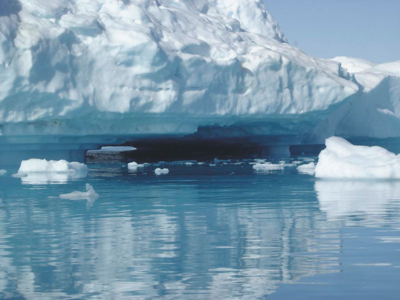
GLISN: Swiss Participation in the Greenland Ice Sheet Monitoring Network
|
The SED participated in building a state-of-the art seismic network in the Arctic. We built and now continue to operate 3 stations in the new international broadband seismic capability for Greenland, the GreenLand Ice Sheet monitoring Network (GLISN). This real-time sensor array enhances and upgrades performance of the very limited pre-existing Greenland seismic infrastructure for detecting and characterizing glacial earthquakes and other phenomena emitting seismic waves. The Greenland Ice Sheet is changing, and seismology has the means to “hear” and measure these changes. Continuous, long-term monitoring of the dynamics of the Greenland Ice Sheet and its relationship to global climate change is a fundamental observational enterprise which requires multi-sensing techniques. The development of GLISN brings the seismology component into focus for monitoring Greenland’s Ice Sheet. Glacial earthquakes have been observed along the edges of Greenland with strong seasonality and increasing frequency since 2002 by continuously monitoring data from the Global Seismographic Network (GSN). These glacial earthquakes in the magnitude range 4.6-5.1 may be modeled as a large glacial ice mass sliding downhill several meters (e.g. 10 km3 by 10 m) on its basal surface over a duration of 30 to 60 seconds. Although the mechanics of sudden sliding motions at the glacial base are not known, seasonal and temporal patterns are consistent with a dynamic response to climate warming driven by an increase in surface melting and supply of meltwater to the glacial base, and suggest that the glacial earthquakes may serve as a marker of ice-sheet response to external forcing. Before GLISN, the detection and characterization of smaller glacial earthquakes was limited by the propagation distance to globally distributed seismic stations. Now, glacial earthquakes can be identified only using the more than 30 GLISN seismic stations within and surrounding Greenland. Because of the long durations of sliding, these glacial earthquakes do not appear in standard earthquake catalogs, and are best detected by broadband seismometers, which accurately measure both fast (< second) and slow (> 100sec) vibrations. Such seismic monitoring of the Greenland Ice Sheet via glacial earthquakes will complement both surficial GPS monitoring and remote sensing from satellites, by providing sensitivity to the dynamics of the glaciers at basal depths. In addition, real-time detection of glacial earthquakes permits rapid response and focusing of other sensing techniques to the dynamic region of the Ice Sheet. All the data from the GLISN is openly available to anyone in real-time, without restriction. |
|---|---|
| Project Leader at SED | John Clinton |
| Funding Source | SNF R’Equip |
| Duration | 2008-2010 |
| Keywords | Greenland, Seismic Networks, Ice Sheet |
| Research Field | Seismic Network, Seismotectonics, Real-time monitoring |
| Link To Project Website | |
| Publications |
Clinton, J. F., M. Nettles, F. Walter, K. Anderson, T. Dahl-Jensen, D. Giardini, A. Govoni, W. Hanka, S. Lasocki, W. S. Lee, D. McCormack, S. Mykkeltveit, E. Stutzmann and S. Tsuboi (2015). Seismic Network in Greenland Monitors Earth and Ice System. Eos Trans. AGU 95(2), 13-14. doi: 10.1002/2014EO020001 |
Earthquake Early Warning
Smartphone-Network for Earthquake and Tsunami Early Warning in Chile

|
Chile has been struck by a number of very large earthquakes (magnitude 7.5 or greater) and tsunamis in the past. There is a clear need for building a system to provide rapid situational awareness, as well as earthquake and tsunami early warning. Since scientific instruments are expensive, we are exploring the use of dense networks of seismic and geodetic low-cost sensors. The Earthquake Science Center oft he U.S. Geological Survey (USGS) has recently started to deploy a prototype network of dedicated smartphone units along the Chilean coast (Brooks et al., 2016). Each sensor box contains a smartphone with integrated MEMS accelerometer, and an external consumer-quality GPS chip and antenna to determine real-time positioning data. The total cost of each box is on the order of a few hundred dollars, nearly two orders of magnitude lower than scientific-grade installations. A first subset of 9 smartphone-boxes has been installed in November 2015; another set of 200 units will be deployed by the end of 2016. We will invert seismic and geodetic real-time data from the smartphone units to obtain finite-fault models of large earthquakes by joint application of the seismic FinDer algorithm developed at the Swiss Seismological Service (SED) (Böse et al., 2012, 2015) and the geodetic BEFORES algorithm developed by Minson et al. (2014). The SED collaborates in this project closely with partners at the USGS, the University of Chile, Chilean National Seismological Center, University of Houston, and GISMatters Inc. |
|---|---|
| Project Leader at SED | Maren Böse |
| SED Project Members | John Clinton |
| Funding Source | United States Agency for International Development (USAID) Office of U.S. Foreign Disaster Assistance (OFDA) |
| Duration | 2015-2016 |
| Keywords | Earthquake Early Warning, Seismic Networks, Low-cost Sensors, Smart-phones, Chile |
| Research Field | Earthquake Early Warning, Real-time monitoring, Network Seismology |
EPOS, EEW Testing Center
EPOS IP is part of the long term EPOS integration plan to build an operational and sustainable platform of Earth Science services. The project is funded through the European Union. In WP 9 (Near fault Observatories) of EPOS IP, we work with our colleagues at the University of Naples / AMRA, to build a testing center where a variety of scientific algorithms for real-time monitoring can be operated side-by-side and their performance independently evaluated. The initial demonstrations software for this testing center are 2 EEW approaches, the Virtual Seismologist (VS) software maintained by ETH, and PresTo from University of Naples / AMRA. The testing platform is the Irpinia seismic network near Naples. |
|
| Project Leader at SED | Dr. John Clinton |
|---|---|
| SED Project Members | Frederick Massin, Philipp Kästli, Enrico Ballarin |
| Funding Source | EU |
| Duration | 2017-2020 |
| Keywords | Earthquake Early Warning, Testing Center |
| Research Field | Real-Time Seismology, Earthquake Engineering |
| Link To Project Website | |
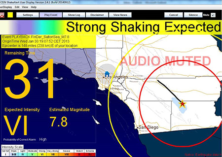
ShakeAlert
|
The objective of the ShakeAlert project is to implement a prototype Earthquake Early Warning (EEW) system for California and the pacific northwest of the United States. The system is currently sending warnings of imminent strong ground shaking to a selected group of test users. The project comprises algorithm development, EEW system design and implementation, and public outreach. The SED was involved in Phase I – III of the project, implementing and testing the Virtual Seismologist (VS) [Cua and Heaton, 2009], a Bayesian approach to EEW. In Phase III, the SED team also began to contribute to the development and implementation of FinDer, the first finite fault algorithm to be included in the prototype system. Currently about 300 scientists and engineers and several project partners from the public and private sector receive alerts from the ShakeAlert EEW system. The ShakeAlert project continues without formal ETH participation, though VS and FinDer continue to be core components in the development system. |
|---|---|
| Project Leader at SED | Georgia Cua (Phase I + II), John Clinton (Phase III) |
| SED Project Members | Michael Fischer (former member), Marta Caprio (former member), Men-Andrin Meier (former member), Yannik Behr (former member), Maren Böse |
| Funding Source | United States Geological Survey |
| Duration | 3 x 3 years |
| Keywords | Prototype Earthquake Early Warning system for California and the Pacific northwest of the United States |
| Research Field | Earthquake Early Warning |
| Link To Project Website | |
| Publications |
Meier, M.-A., T. Heaton, and J. Clinton (2015). The Gutenberg Algorithm: Evolutionary Bayesian Magnitude Estimates for Earthquake Early Warning with a Filter Bank. Bull. Seismol. Soc. Am. 105(5), 2774-2786. doi: 10.1785/0120150098 Böse, M., C. Felizardo, T.H. Heaton (2015). Finite-Fault Detector Algorithm (FinDer): Going Real Time in Californian ShakeAlert Warning System. Seismological Research Letters 86(6), in press. Behr, Y., J. F. Clinton, P. Kästli, C. Cauzzi, and M.-A. Meier (2015). Anatomy of an Earthquake Early Warning ( EEW ) Alert : Predicting Time Delays for an End-to-End EEW System. Seismological Research Letters 86(3), 1-11. doi: 10.1785/0220140179 Cua, G. B., M. Fischer, T. H. Heaton, and S. Wiemer (2009). Real-time Performance of the Virtual Seismologist Earthquake Early Warning Algorithm in Southern California. Seismological Research Letters 80(5), 740-747. doi: 10.1785/gssrl.80.5.740 |
| Presentations |
G. Cua, R. Allen, M. Boese, H. Brown, D. Given, M. Fischer, E. Hauksson, T. Heaton, M. Hellweg, M. Liukis, T. Jordan, O. Khainovski, P. Maechling, D. Neuhauser, D. Oppenheimer, K. Solanki, M. Caprio Three Years of Comparative Real-Time Earthquake Early Warning Testing in California. PDF Yannik Behr, John Clinton, Philipp Kästli, Roman Racine, Men-Andrin Meier, Carlo Cauzzi, Georgia Cua What to Expect from the Virtual Seismologist: Delay Times and Uncertainties of Initial Earthquake Alerts in California. PDF |
REAKT: Strategies and Tools for REal Time EArthquake RisK ReducTion
|
The general objective of this EC-FP7 funded joint project was to improve the efficiency of real time earthquake risk mitigation methods and its capability of protecting structures, infrastructures and people. REAKT aimed at establishing the best practice on how to use jointly all the information coming from earthquake forecast, early warning and real time vulnerability assessment. All this information needs to be combined in a fully probabilistic framework, including realistic uncertainties estimations, to be used for decision making in real time. REAKT used a system-level earthquake science approach that required that the various temporal scales of relevance for hazard and risk mitigation in the various WPs are integrated through common tools, databases and methods. Our group was involved in the Work Package 2: Physics of short term seismic changes and its use for large earthquakes predictability. The key objective was to improve short-term forecasting of large earthquakes through the monitoring of the seismic and strain activity within specific fault systems. We contributed with the monitoring system, which has been installed in the Valais region including dense seismic network, GPS, geochemical and geomagnetic sensors. Special attention was paid to the analysis of seismic swarms. |
|---|---|
| Project Leader at SED | Donat Fäh |
| SED Project Members | Jan Burjanek |
| Funding Source | EC |
| Duration | 2011-2014 |
| Keywords | short term seismic changes, earthquake precursors |
| Research Field | |
| Reports / Deliverables |
Seismotectonics
AlpArray
|
AlpArray is a European initiative to advance our understanding of orogenesis and its relationship to mantle dynamics, plate reorganizations, surface processes and seismic hazard in the Alps-Apennines-Carpathians-Dinarides orogenic system. The initiative integrates present-day Earth observables with high-resolution geophysical imaging of 3D structure and physical properties of the lithosphere and of the upper mantle, with focus on a high-end seismological array. AlpArray is a major scientific collaboration with over 40 participant institutions. One of the main actions of the AlpArray initiative is to collect top-quality seismological data from a dense network of temporary broadband seismic stations. This complements the existing permanent broadband stations to ensure homogeneous coverage of the Alpine area, with station spacing on the order of 30km. 24 institutions are currently involved in the AlpArray Seismic Network (AASN), which will eventually install over 250 temporary stations in 12 countries. The AASN officially started on 1 January 2016 and will operate for at least 2 years. A complimentary ocean bottom seismometer (OBS) component is expected in 2017. The Swiss contribution to the AASN is completed, with 23 temporary stations installed in Switzerland, Italy, Bosnia and Herzogovina, Croatia and Hungary. All national broadband stations also contribute to the AASN. The Seismology and Geodynamics group (SEG) and the Swiss Seismological Service (SED) at the ETH in Zurich take leading roles in the project. Prof Edi Kissling is the project coordinator. Irene Molinari (SEG), John Clinton (SED) and Gyorgy Hetenyi (former SED, now at the University of Lausanne) lead AlpArray working groups, Irene Molinari also manages the Swiss component of the AASN. More information is available on the project website. |
|---|---|
| Project Leader at SED | Prof. Edi Kissling (SEG) |
| SED Project Members | Irene Molinari (SEG), John Clinton, Stefan Wiemer, ELAB |
| Funding Source | SNF |
| Duration | 2015 - 2018 |
| Keywords | Alps, earthquakes, seismic broadband network, tomography, geodynamics, surface process, orogenesis |
| Research Field | Seismotectonics, Real-time monitoring, Earthquake Hazard & Risk |
| Link To Project Website | |
| Proposal |
|
| Publications |
|
SAMSFAULTZ: Structure and Mechanics of Seismogenic Fault Zones
|
Um in Zukunft die Gefahren von natürlichen und induzierten Erdbeben besser abschätzen zu können, braucht es ein genaueres Verständnis von Verwerfungszonen in tektonisch aktiven Gebieten wie der Schweiz. Mit Hilfe geophysikalischer Abbildungsverfahren und geologischen Kartierungen wurden in den letzten Jahren zahlreiche Verwerfungen in den schweizerischen Alpen und im nördlichen Alpenvorland identifiziert. Allerdings treten in vielen Fällen Erdbeben abseits dieser kartierten Verwerfungen auf, was die Frage nach den tektonischen Prozessen und Mechanismen aufwirft, die diesen Erdbeben zugrunde liegen. Ziel dieses Projektes ist es, durch verbesserte geophysikalische Inversionsverfahren die Strukturen von Verwerfungszonen hochauflösend abzubilden und daraus Erkenntnisse über mechanische Eigenschaften der Bruchsysteme abzuleiten. Dazu werden unter anderem Verfahren der seismischen Tomografie mit hochauflösender Erdbebenlokalisierung kombiniert. Die Anwendung konzentriert sich auf zwei Regionen in der Schweiz: (i) einer äußerst aktiven Erdbebenzone nördlich des Rhônetals im Kanton Wallis, (ii) einer Verwerfungszone nahe St. Gallen, die während Stimulationsmaßnahmen für ein geplantes Geothermiekraftwerk aktiviert wurde. Durch die Anwendung verbesserter Abbildungsverfahren erwarten wir zum einen neue Erkenntnisse über den Zusammenhang zwischen existierenden Verwerfungen und dem Auftreten von Erdbeben. Zudem sind die beiden Untersuchungsgebiete von hoher gesellschaftlicher Relevanz. Das Wallis ist die Region mit der größten seismischen Gefährdung der Schweiz und ein Großteil der gegenwärtigen Seismizität in diesem Gebiet steht in Verbindung mit der Erdbebenzone nördlich des Rhônetals. Die St. Gallen Verwerfungszone bietet Gelegenheit zur Untersuchung der Erdbebengefährdung im dicht besiedelten Molasse Becken, welches potentieller Standort zukünftiger Geothermieprojekte und atomarer Endlager ist. |
|---|---|
| Project Leader at SED | Dr. Tobias Diehl |
| SED Project Members | Edi Kissling, Stefan Wiemer |
| Funding Source | SNF |
| Duration | 2016-2019 |
| Keywords | seismicity, seismotectonic, earthquake location, seismic tomography, reflection seismics, induced seismicity, geothermal energy, fault zone, Rawil, St. Gallen, Valais, seismic hazard, Molasse basin |
| Research Field | Seismotectonics (main), but also: Induced Seismicity, Swiss Seismicity, Earthquake Statistics |
| Proposal |
|
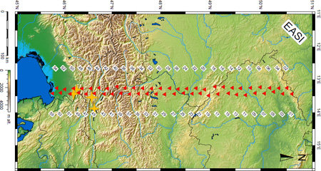
EASI: Eastern Alpine Seismic Investigation
|
The Eastern, "straight" part of the Alps is home to a number of open questions. The most widespreadly known question is about lithospheric slab hanging beneath the Eastern Alps. Is it Adriatic (Lippitsch et al. 2003)? Is it European (Mitterbauer et al. 2011)? What is its extent and the related velocity anomaly? Beyond carrying out tomographic calculations, one can also characterize the fabric of the lower crust with receiver functions. In the India-Asia collision zone this has helped to point out that the main lithosphere boundary is located at a very different place than the surface boundary of deformation. Anisotropic receiver function calculations are therefore one of the first tools to be applied on EASI data, with the main question of determining the role of the lower crust in shaping the orogen. A recent Moho map compilation reveals another interesting features beneath the Eastern Alps and between the Europe and Adria plates: a Moho "gap" or "hole" (Spada et al. 2013). Near 47°N latitude and between 12° and 15.5°E longitude the crust-mantle boundary is not defined, or at least it does not appear as a sharp discontinuity. Mapping the extent of this hole, and characterizing the velocity gradient from crustal to mantle conditions is an interesting goal to tackle. The relationship of the Alpine orogen to the adjacent foreland basin and the lithospheric blocks of the Bohemian Massif, with their own characteristic seismic signatures, is a structural target of EASI. Our research methods include tomography, ambient noise analysis and receiver functions, with anisotropy included in all three types of investigations. The depth range of investigations encompasses the crust and the mantle lithosphere, down to the LAB. |
|---|---|
| Project Leader at SED | György Hetényi |
| SED Project Members | Edi Kissling (SEG) |
| Funding Source | ETH (for the Swiss part) |
| Duration | 2 years |
| Keywords | Alps, continental collision, seismology, geodynamics, geophysics, crust, lithosphere, earthquake, seismotectonics, slab, Moho |
| Research Field | Earth structure, Seismotectonics, Geodynamics |
GANSSER: Geodynamics ANd Seismic Structure of the Eastern-Himalaya Region
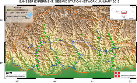
|
Bhutan, a kingdom in the Eastern Himalayas, is living in self-imposed isolation: in order to preserve local culture, traditions and the environment, foreigners can enter in groups and in limited number only. Consequently, our geoscientific knowledge is very limited compared to other parts of the orogen. The first geological map was compiled in 1983 by the famous Swiss geologist Augusto Gansser. From a geophysical perspective, Bhutan is almost a blank spot: only very limited information exists on seismicity which shows a lower level of earthquake activity compared to other parts of the Himalayas; there is knowledge neither of the structure nor of the physical properties of the crust and the lithosphere. Illuminating the deep structure of Bhutan and comparing it with the much better known Central Himalayas of Nepal is highly relevant both for evaluating the earthquake hazard and for improving our geodynamic picture of the orogen. We conducted a temporary seismic experiment in Bhutan. Two densely spaced profiles across the orogen allow us to produce the first images of the structure of the lithosphere in the Eastern Himalayas, as well as give an insight into lateral variations along the mountain belt. Our network provides reliable information on seismicity in Bhutan and establishes the first seismic velocity model of the crust. Furthermore, we will apply ambient noise tomography to map the physical properties of the lithosphere. The results will be interpreted jointly with gravity data to build physical models of the Eastern Himalayas as well as to draw conclusions on its geodynamics. Especially, seismotectonic studies that we plan to conduct by comparing different segments of the Himalayas may shed light on the origin of the apparent seismic gap in Bhutan. Augusto Gansser, "Geology Father of the Himalayas" and first geological mapmaker of Bhutan, has passed away earlier this year (2012), at the age of 101. We would like to dedicate this experiment to his memory. Outreach
|
|---|---|
| Project Leader at SED | György Hetényi |
| SED Project Members | Tobias Diehl, John Clinton, Julia Singer (SEG), Edi Kissling (SEG) |
| Funding Source | SNF |
| Duration | 3 years |
| Keywords | Himalaya, Bhutan, continental collision, seismology, geodynamics, geophysics, crust, lithosphere, earthquake, seismotectonics |
| Research Field | Earth structure, Seismotectonics, Geodynamics, Earthquake Hazard & Risk |
Microseismic Monitoring of Northern Switzerland
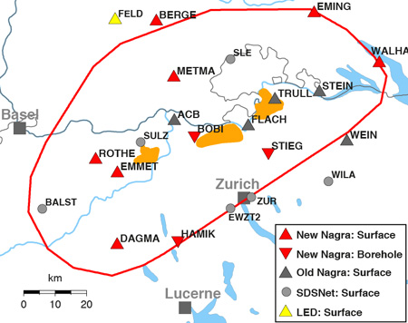
|
This project is carried out under a contract with the National Cooperative for the Disposal of Radioactive Waste (Nagra). It provides an independent monitoring of the earthquake activity in the area of the proposed nuclear waste repositories in northern Switzerland. Detailed microseismic analysis will help to identify active fault zones and provide insights into the underlying seismotectonic processes in the vicinity of proposed sites, which has direct implications on the seismic hazard assessment. The SED provides results of this project in a transparent manner and all data acquired are made available for public access (see SED declaration on transparency [link]). Within this project, the Swiss Seismological Service (SED) constructed ten new seismic stations in northeastern Switzerland and southern Germany to improve monitoring capabilities for very small earthquakes. Monitoring of weak seismic events in this region is challenging, because the study region is densely populated and sediments of the Molasse basin dominate the surface geology. A novel step-wise optimization approach was developed to ensure an optimum configuration of the new stations. To reduce the seismic background noise, three of the ten new sites were equipped with borehole-sensors, located at depths of 120–150 m below the surface. The new stations are fully operational since December 2013 and will observe the local seismicity in northern Switzerland for a minimum of ten years. The newly installed stations complement the five stations installed in 2003 under a first agreement with Nagra. With these ‘Nagra’ stations, together with stations of the Swiss National Seismic Network and stations of neighboring networks in Germany, the project aims to monitor earthquakes down to magnitudes of 1.0 and smaller in the study area. We intend to achieve an overall catalog completeness of Mc 1.3 throughout northeastern Switzerland and location errors less than 0.5 km in epicenter and less than 2 km in focal depth within the study region. Accurate earthquake locations are essential for seismotectonic interpretations. Within this project we therefore aim to improve location accuracy, especially for focal depths, of past and future earthquakes in the region. |
|---|---|
| Project Leader at SED | Dr. Tobias Diehl |
| SED Project Members | Florian Haslinger, Stefan Wiemer, Donat Faeh, Toni Kraft, John Clinton |
| Funding Source | Nagra |
| Duration | 2013-2019 |
| Keywords | seismicity, seismotectonic, earthquake location, seismic hazard, Molasse basin, nuclear waste repositories |
| Research Field | Seismotectonics (main), but also: Swiss Seismicity, Real-time monitoring, Earthquake Hazard & Risk |
| Publications |
|
Induced Seismicity
COSEISMIQ: Control SEIsmicity and Manage Induced earthQuakes
|
Over the last decade induced seismicity has become an important topic of discussion, especially owing to the concern that industrial activities could cause damaging earthquakes. Large magnitude induced seismic events are a risk for the population and structures, as well as an obstacle for the development of new techniques for the exploitation of underground georesources. The problem of induced seismicity is particularly important for the future development of geothermal energy in Europe, in fact deep geothermal energy exploitation projects such as Basel (2006) and St Gallen (2013) have been aborted due to the felt induced earthquakes they created and an increasing risk aversion of the general population. Induced seismicity is thus an unwanted product of such industrial operations but, at the same time, induced earthquakes are also a required mechanism to increase the permeability of rocks, enhancing reservoir performances. Analysis of induced microseismicity allows to obtain the spatial distribution of fractures within the reservoir, which can help, not only to identify active faults that may trigger large induced seismic events, but also to optimize hydraulic stimulation operations and to locate the regions with higher permeability, enhancing energy production. The project COSEISMIQ integrates seismic monitoring and imaging techniques, geomechanical models and risk analysis methods with the ultimate goal of implementing innovative tools for the management of the risks posed by induced seismicity and demonstrate their usefulness in a commercial scale application in Iceland. Seismic stations of the COSEISMIQ project (PDF, 0.13 MB) |
|---|---|
| Project Leader at SED | Prof. Stefan Wiemer |
| SED Project Members | John Clinton, Francesco Grigoli, Florian Haslinger, Lukas Heiniger, Philipp Kaestli, Raphael Moser, Anne Obermann, Roman Racine, Antonio Pio Rinaldi, Vanille Ritz, Luca Scarabello. |
| Funding Source | |
| Duration | 3 years (start in May 2018) |
| Keywords | Induced Seismicity |
| Research Field | Induced Seismicity, Earthquake Hazard & Risk, Real-time microseismic monitoring |
| Link To Project Website |
DESTRESS: Demonstration of Soft Stimulation Treatments of Geothermal Reservoirs
|
DESTRESS is a Horizon 2020 supported programme aiming to demonstrate methods of EGS (enhanced geothermal systems) and thereby expanding knowledge and providing solutions for a more economical, sustainable and environmentally responsible exploitation of underground heat. EGS allow a widespread use of the enormous untapped geothermal energy potential. DESTRESS improves the understanding of technological, business and societal opportunities and risks related to geothermal energy. The concepts explored are based on experiences in previous projects (e.g. GEISER), on scientific progress and developments in other fields, mainly the oil and gas sector. Recently developed stimulation methods are adapted to geothermal needs, applied to new geothermal sites and prepared for the market uptake. The main focus lays on stimulation treatments with minimized environmental hazard, which address site-specific geological requirements. The overall objective is to develop best practices in creating a reservoir with increased transmissivity, sustainable productivity and a minimized level of induced seismicity. Existing and new project’s test sites, pilot and demonstration facilities were chosen to demonstrate the DESTRESS concept. DESTRESS assembles an international consortium involving major knowledge institutes and key industry from Europe and South Korea to guarantee the increase in EGS-technology performance and accelerated market penetration. |
|---|---|
| Project Leader at SED | Prof. Stefan Wiemer |
| SED Project Members | Dr. Toni Kraft, Michèle Marti, Stephanie Schnydrig |
| Funding Source | SBFI |
| Duration | 2016-2020 |
| Keywords | EGS (Enhanced geothermal systems), induced seismicity, risk mitigation, stimulation, demonstration sites |
| Research Field | Induced Seismicity |
| Link To Project Website |
Induced Seismicity in Geological Nuclear Waste Disposal
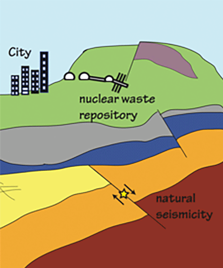
|
This is the 3rd subproject of the „ENSI – SED-Erdbebenforschung zu Schweizer Kernanlagen“ project. Subproject 3 aims at studying the relevancy of induced seismicity for the disposal of nuclear waste at geological depth. We will update/develop physics-based modeling of induced seismicity, and we will apply such models to the case of nuclear waste disposal. Moreover, the approach will be validated by reproducing the observations from the “Fault Slip experiment” at Mont Terri underground laboratory. Finally, numerical modeling will be performed to study the seismicity induced by tunnel excavation, as well as to better understand the possible occurrence of seismicity by temperature changes around disposal site. Collaboration with Subproject 1 and 2 will be crucial to properly estimate the hazard and risk of induced seismicity on geological nuclear waste disposal. |
|---|---|
| Project Leader at SED | Donat Fäh |
| SED Project Members | Antonio P. Rinaldi, Luca Urpi |
| Funding Source | Swiss Federal Nuclear Safety Inspectorate - ENSI |
| Duration | 2014-2018 (1st phase), 2018-2022 (2nd phase) |
| Keywords | Geomechanics, Induced seismicity, THM modeling |
| Research Field |
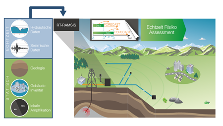
RT-RAMSIS
|
RT-RAMSIS is a joint CTI project between the Swiss Seismological Service SED and GeoEnergie Suisse AG. It builds on research results from previous joint research projects GEOSIM and GEOBEST. We are developing and validating a near real time hazard and risk assessment framework for induced seismicity in geothermal projects. With fluid injection rates and micro-earthquakes recorded in near real-time and prepared as input, the framework uses statistical and hybrid statistical-hydromechanical ensemble models to forecast seismicity in six hour intervals. Subsequent stages then compute probabilistic seismic hazard and risk estimates based on different injection scenarios and thereby help the operator to balance risk and reservoir stimulation efficiency. Core research activities in this project are in the development of fast, reliable and precise micro-earthquake detection algorithms, in the assessment and weighting of forecast model performance and in the enhancement and validation of statistical and mechanical seismic forecast models. |
|---|---|
| Project Leader at SED | Stefan Wiemer |
| SED Project Members | Lukas Heiniger, Dimitrios Karvounis, Daniel Armbruster |
| Funding Source | KTI, GES |
| Duration | 1.1.2016 – 30.6.2019 |
| Keywords | Induced Seismicity, advance traffic light system, seismic hazard and risk, anthropogenic seismici-ty, deep underground, ensemble modeling |
| Research Field | Induced Seismicity, Swiss Seismicity, Earthquake Hazard & Risk, Real-time monitoring |
SIAMIS-GT
|
|
One of the unsolved challenges for deep geothermal projects is how to mitigate unacceptably large, induced earthquakes. Unfortunately, the processes and conditions underpinning induced seismicity are still not sufficiently well understood to make useful predictions of the likely seismic response to geothermal reservoir development and exploitation. This predictability is further reduced by the sparse knowledge of the hydro-mechanical and geological conditions in the deep underground, and our lacking ability to map them well enough with current technologies. The seismic response to deep geothermal operations can, however, be monitored in real-time by seismological methods. These methods are, therefore, the core element of any traffic light system (TLS) for induced seismicity that was proposed in recent years. In this project SIAMIS-GT (Improvement of SeIsmological Analysis Methods to better support cantonal authorities in questions related to Induced Seismicity in deep GeoThermal projects), we want to improve seismological analysis methods for monitoring induced seismicity by taking advantage of the waveform similarity observed in these earthquake sequences. The goal is to enable the SED to inform authorities, project developers and the population faster and more accurately about induced earthquakes that may occur during geotechnical projects (e.g., geothermal, mining, tunneling, etc.). We plan to apply similarity and repeating earthquake analysis to induced seismicity to improve the understanding of the source mechanics (i.e., distinction of natural versus induced seismicity, improved detection, localization and characterization). With these methods we also hope to be able to resolve aseismic changes in the subsurface that cannot be resolved using classical methods in real-time. Figure on the left: Illustration of the basic principles of similarity location. Upper left: waveforms of 7 template earthquakes used for template matching of the Diemtigen swarm. Upper right: Epicenter map of 306 relocated earthquakes color-coded by highest similarity to the 7 templates. Red diamonds indicate the location of the templates. Notice that earthquakes cluster closely around the template they are associated to by waveform similarity. Bottom: Relationship between inter-event distance and waveform similarity for each template with respect to the 306 relocated earthquakes. Color indicates the reference template. It can be clearly seen that similarity decreases strongly with inter-event distance and that individual relationships can be derived for every reference template. |
|---|---|
| Project Leader at SED | Dr. Toni Kraft |
| Funding Source | Swiss Federal Office of Energy |
| Duration | 2016-2021 |
| Keywords | Induced Seismicity, Induced Earthquake Hazard and Risk, Real-time monitoring, Support and consultancy |
| Research Field | Induced Seismicity |
| Publications |
|
To Induce or Not to Induce: an Open Problem - Study on Injection-induced Seismicity for Geo-energy Applications, from Lab to Field Scale
|
In the last few years, major and damaging earthquakes were felt in regions supposedly affected by a low rate of natural seismicity. Such events have become an extremely important topic of discussion in both Europe and North America, since several major events were associated to industrial activities. The main focus of this proposed research is the study of induced seismicity during exploitation of natural underground resources. More specifically, this proposal focuses on one side on a detailed understanding of the deep fault and/or fractures reactivation associated with the fluid injection. On the other side, the proposed research plans to investigate the mitigation of large magnitude induced seismicity, which may pose at risk the affected population and structures, as well as acting as obstacle to the development of new techniques for the exploitation of deep underground resources. First the project aims to understand the physics associated with the induced seismicity caused by anthropogenic activities. Secondly, the project aims to investigate in which conditions fluid-induced seismicity can be used as a tool. For example, the shearing process of fault and fracture, or the creation of new fractures, are needed to increase the permeability, and hence to enhance the fluid circulation at depth, eventually resulting in a more efficient energy production. However, such processes may, at the same time, produce seismicity that can be felt by local population.
Understanding the fundamental processes will help in finding new methods to safely extract energy, whose request nowadays is constantly increasing. The project will address the above open questions by theoretical studies, laboratory, and applied fieldwork. I plan to use data collected from on-going experiments (laboratory and in-situ) to improve numerical models. Numerical tools to be used include: thermo-hydromechanical modeling (THM), discrete fracture network (DFN), and statistical, as well as hybrid simulators. |
|---|---|
| Project Leader at SED | Dr. Antonio Pio Rinaldi |
| SED Project Members | Dominik Zbinden (PhD) |
| Funding Source | SNF |
| Duration | 2015 - December 2018 |
| Keywords | Numerical modeling, Geomechanics, Hydrogeology, Multi-scale |
| Research Field | Induced Seismicity, Geothermal Energy, CO2 sequestration |
Towards an improved understanding of anthropogenic earthquakes: Exploiting the Grimsel controlled fault slip experiment
|
The first phase of this project involves the participation in the In-situ Stimulation and Circulation (ISC) experiment at the Grimsel Test Site. Goal of the experiment series is the permeability enhancement of a decameter rock volume intersected with two fault zones. The permeability enhancement process is accompanied by slip along the faults, which is achieved by high-pressure fluid injection (i.e. hydraulic shearing). Fluid injection is performed in several borehole sections distributed over two injection boreholes drilled trough the target fault zones. During the experiment hydraulic processes, mechanical processes and induced micro-seismicity are monitored with an unprecedented multi-sensor monitoring system leading to a unique and high quality dataset. The third phase of the project will bring together micro-seismic data and other measured data during the experiment and shed light into the physical understanding of induced earthquakes. Finally, forecasting skills of models for induced seismicity are tested on the Grimsel high quality dataset. |
|---|---|
| Project Leader at SED | Prof. Stefan Wiemer |
| SED Project Members | Paul Selvadurai, Linus Villiger |
| Funding Source | ETH |
| Duration | September 2016 to September 2019 |
| Keywords | Induced seismicity, Hydraulic stimulation, Crystalline rock |
| Research Field | Induced Seismicity, Engineer Seismology |
Monitoring Geothermieprojekt St. Gallen
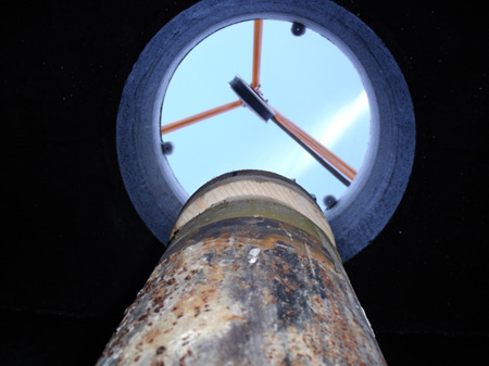
|
As part of the GEOBEST-CH research project, the Swiss Seismological Service (SED) has been carrying out seismological monitoring of the geothermal project of the city of St. Gallen since spring 2012. To this end, the SED has built six new seismological stations in the St. Gallen area in cooperation with the St. Galler Stadtwerke (sgsw). The aim of the monitoring is to detect possible small earthquakes - so-called microearthquakes - in the vicinity of the deep wells and to clarify whether these are related to the geothermal project or of natural origin. In addition, the project will collect important fundamental data for a better understanding of deep geothermal energy, which is an indispensable source of experience for ensuring planning reliability fort the cantonal authorities and project operators in future geothermal projects. Following the termination of the geothermal project in spring 2014, the SED will continue to monitor in a reduced form until at least September 2020. St. Gallen Stadtwerke support the monitoring in the framework of the EU project "Science for Clean Energy (S4CE)". |
|---|---|
| Project Leader at SED | Dr. Toni Kraft |
| SED Project Members | INDU group |
| Funding Source | Bundesamt für Energie, Sankt Galler Stadtwerke |
| Duration | 2012-2020 |
| Keywords | |
| Research Field | Induced Seismicity, Real-time monitoring |
| Link To Project Website | |
| Publications |
Diehl, T., Kraft, T., Kissling, E. and Wiemer, S. (2017). The induced earthquake sequence related to the St. Gallen deep geothermal project (Switzerland): Fault reactivation and fluid interactions imaged by microseismicity. Journal of Geophysical Research 122(9), 1-19. doi: 10.1002/2017JB014473 Edwards, B., Kraft, T., Cauzzi, C., Kastli, P. and Wiemer, S. (2015). Seismic monitoring and analysis of deep geothermal projects in St Gallen and Basel, Switzerland. Geophys. J. Int. 201, 1020-1037. Obermann, A., Kraft, T., Larose, E. and Wiemer, S. (2015). Potential of ambient seismic noise techniques to monitor the St. Gallen geothermal site (Switzerland). J. Geophys. Res. Solid Earth 120(6), 4301–4316. doi: 10.1002/2014JB011817 Kraft, T. et al. (2015). Lessons learned from the 2013 ML3.5 induced earthquake sequence at the St. Gallen geothermal site. Schatzalp Workshop on Induced Seismicity, Davos, Switzerland. Diehl, T., Kraft, T., Kissling, E., Deichmann, N., Clinton, J. and Wiemer, S. (2014). High-precision relocation of induced seismicity in the geothermal system below St. Gallen (Switzerland). EGU General Assembly Conference Abstracts 16, 12541. Kraft, T., Wiemer, S., Deichmann, N., Diehl, T., Edwards, B., Guilhem, A., Haslinger, F. et al. (2013). The ML 3.5 earthquake sequence induced by the hydrothermal energy project in St. Gallen, Switzerland. AGU Fall Meeting Abstracts 1, 3. |
GEOTHERM-2
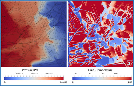
|
GEOTHERM-2 conducts cross-disciplinary research towards the development of Enhanced Geothermal Systems (EGS). EGS is a technology that will allow the heat resources residing at several kilometers depths to be exploited for electricity and heat production. At present, EGS technology is not mature; two of the key challenges are the difficulty of (1) engineering a lasting heat exchanger with appropriate properties within deep, hot, low-porosity rocks, and (2) the risk of inducing felt and potentially hazardous seismic events during the development and operation of the heat exchanger. GEOTHERM-2 continues the work initiate in the GEOTHERM-1 project (2009-2012). The project was conceived in order to provide a bridge to a major nationwide project in geothermal energy, the Swiss Competence Center Energy Research-Supply of Energy (SCCER-SoE), that was in its planning phase when GEOTHERM-2 was proposed, and has begun in the meantime. In total thirty eight co-workers from various Departments and Institutes in ETH and in EPFL, and of the Paul Scherrer Institute contribute to the project. The main strength of GEOTHERM-2 is to adopt a cross-disciplinary approach to the challenges mentioned above. The contributions of GEOTHERM-2 in terms of scientific results, capacity building and knowledge transfer are a therefore critical intermediate step towards successful future Pilot and Demonstration projects, and complement the activities conducted in SCCER-SoE. The research activities in GEOTHERM-2 are organized in six Modules or work packages, which are designed to:
|
|---|---|
| Project Leader at SED | Prof. Dr. Stefan Wiemer |
| SED Project Members | Prof. Dr. Stefan Wiemer, Dr. Alba Zappone, Dr. Laurentiu Danciu, Dr. Pierre Dublanchet, Dr. Valentin Gischig, Dr. Dimitrios Karvounis, Eszter Király, Dr. Toni Kraft, Lukas Heiniger, Marcus Herrmann, Dr. Anne Obermann, Dr. Arnaud Mignan, Barbara Schechinger |
| Funding Source | Competence Center Environment Sustainability (CCES), Competence Center Energy and Mobility (CCEM) and Bundesamt Für Energie (BFE) |
| Duration | 2013 - 2016 |
| Keywords | Energy, geothermy, multidisciplinary |
| Research Field | Induced Seismicity, Geomechanics, Geochemistry, energy conversion systems, Social Acceptance |
| Link To Project Website | |
| Publications |
Deichmann N., Kraft T. and Evans K.F. (2014). Identification of faults activated during the stimulation of the Basel geothermal project from cluster analysis and focal mechanisms of the larger magnitude events. Geothermics 52, 84-97. doi: 10.1016/j.geothermics.2014.04.001 Driesner, T. (2013). The Molecular-Scale Fundament of Geothermal Fluid Thermodynamics. Reviews in Mineralogy and Geochemistry 76, 5-33. doi: 10.2138/rmg.2013.76.2 Gischig, V., and Wiemer, S. (2013). A stochastic model for induced seismicity based on non-linearpressure diffusion and irreversible permeability enhancement. Geophys. J. Int.. doi: 10.1093/gji/ggt164 Hillers, G., Husen, S., Obermann, A., Planès, T., Campillo, M. and Larose, E. (2015). Noise based monitoring and imaging resolve reservoir dynamics associated with the 2006 Basel injection experiment. Geophysics 80(4), 51-68. doi: 10.1190/GEO2014-0455.1 Hingerl, F.F., Kosakowski, G., Wagner, T., Kulik, D.A. and Driesner, T. (2014). GEMSFIT: a generic fitting tool for geochemical activity models. Computational Geosciences 18(2), 227-242. doi: 10.1007/s10596-014-9405-3 Hingerl, F.F., Wagner, T., Kulik, D.A., Thomsen ,K. and Driesner, T. (2014). A new aqueous activity model for geothermal brines in the system Na-K-Ca-Mg-H-Cl-SO4-H2O from 25 to 300°C. Chem. Geol. 381, 78-93. doi: 10.1016/j.chemgeo.2014.05.007 Hirschberg, S., Wiemer, S. and Burgherr, P. (2015). Energy from the earth: Deep geothermal as a resource for the future?. TA-Swiss, Bern, Switzerland, 220-251. Kaiser, P.K., Valley, B., Dusseault, M.B. and Duff, D. (2013). Hydraulic Fracturing Mine Back Trials – Design Rational and Project status. In: Bunger, A.P., McLennan, J. and Jeffrey, R. : Effective and sustainable hydraulic fracturing. InTech. doi: 10.5772/56260 Kraft, T. and Deichmann, N. (2014). High precision relocation and focal mechanism of the injection induces seismicity at the Basel EGS. Geothermics 52, 59-73. doi: 10.1016/j.geothermics.2014.05.014 Obermann, A., Kraft, T., Larose, E. and Wiemer, S. (2015). Potential of ambient seismic noise techniques to monitor reservoir dynamics at the St. Gallen geothermal site (Switzerland). JGR. doi: 10.1002/2014JB011817 Preisig, G., Eberhardt, E., Gischig, V., Roche, V., van der Baan, M., Valley, B., Kaiser, P.K., Duff, D. and Lowther, R. (2015). Development of connected permeability in massive crystalline rocks through hydraulic fracture propagation and shearing accompanying fluid injection. Geofluids 15, 321-337. doi: 10.1111/gfl.12097 Rivera, J.A., Blum, P. and Bayer, P. (2015). Analytical simulation of groundwater flow and land surface effects on thermal plumes of borehole heat exchangers. Applied Energy 146, 421-433. doi: 10.1016/j.apenergy.2015.02.035 Spada, M., Sutra, E., Wolf, S. and Burgherr, P. (2014). Accident Risk Assessment for Deep Geothermal Energy Systems. In: Nowakowski, T., Mlynczak, M., Jodejko-Pietruczuk, A. and Werbinska-Woiciechowska, S.: Safety and Reliability: Methodology and Applications. Taylor and Francis Group, London UK. Stauffacher, M., Muggli, N., Scolobig, A. and Moser, C. (2015). Framing deep geothermal energy in mass media: the case of Switzerland. Technological Forecasting and Social Change 98, 60–70. doi: 10.1016/j.techfore.2015.05.018 Weis, P., Driesner, T., Coumou, D. and Geiger, S. (2014). Hydrothermal, multiphase convection of H2O-NaCl fluids from ambient to magmatic temperatures: a new numerical scheme and benchmarks for code comparison. Geofluids 14(3), 347-371. doi: 10.1111/gfl.12080 Zezin, D., Driesner, T. and Sanchez-Valle, C. (2015). Volumetric Properties of Na2SO4–H2O and Na2SO4–NaCl–H2O Solutions to 523.15 K, 70 MPa. J. Chem. Eng. Data 60(4), 1181–1192. doi: 10.1021/je501152a Zezin, D., Driesner, T. and Sanchez-Valle, C. (2014). Volumetric Properties of Mixed Electrolyte Aqueous Solutions at Elevated Temperatures and Pressures. The System KCl–NaCl–H2O to 523.15 K, 40 MPa, and Ionic Strength from (0.1 to 5.8) mol·kg–1. Journal of Chemical and Engineering Data 59, 736-749. doi: 10.1021/je400761c |
Risk, Safety and Societal Acceptance (SCCER-SoE Task 4.1)
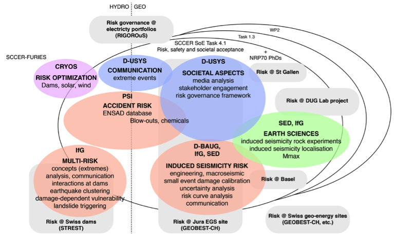
|
The exploitation of underground energy resources as well as the use and expansion of hydropower are, like any other energy technology, not risk free. To address this risk, we develop upon the holistic concept of risk governance and community resilience, advocating a broad picture of risk: In addition to risk analysis and risk management, we also investigate how risk-related decision-making unfolds when a range of actors is involved. This requires coordination and possibly reconciliation between a profusion of roles, perspectives, goals and activities. Developments include: a rigorous common methodology and a consistent modelling approach to hazard, vulnerability, risk, resilience and societal acceptance assessment of energy technologies; a stress test framework and its application to assess the vulnerability and resilience of individual critical energy infrastructures, as well as the first level of interdependencies among these infrastructures; standardized protocols, operational guidelines and/or softwares for monitoring strategies, hazard and risk assessment during all project phases (including real-time procedures), and finally for mitigation and related communication strategies. In phase II, the main activities of the group are in continuation with phase I but with increased interactions with Swiss P&D projects, including industrial ones and research underground labs. New applications are being developed and tested for induced seismicity risk mitigation. Those are also refined based on P&D project feedback. The main innovations in phase II are the testing of more sophisticated traffic-light systems and the inclusion of seismic risk models in economic models (including energy modelling, cost-benefit analyses and decision making under uncertainty). For the latter, interactions with SCCER CREST via a joint activity will help move forward with some legislative recommendations. |
|---|---|
| Project Leader at SED | Prof. Stefan Wiemer |
| SED Project Members | Dr. Arnaud Mignan, Marcus Herrmann |
| Funding Source | SCCER-SoE |
| Duration | 2014-2017 (1st phase), 2018-2012 (2nd phase) |
| Keywords | Geo-energy, induced seismicity risk, risk governance, software |
| Research Field | Earthquake Hazard & Risk |
| Link To Project Website | |
| Reports / Deliverables |
|
FASTER
Novel unconventional geothermal technologies that require hydraulic stimulation through induced seismicity, also require Forecasting and Assessing Seismicity and Thermal Evolution in geothermal Reservoirs (FASTER). This task needs to be performed in real time and both regulators and operators wish to know the probability of a future undesired large induced event in time for risk mitigation measurements to be employed. Fundamental and applied research with the ultimate goal to develop strategies and tools for managing and limiting induced seismicity is a major international focus of current research in geophysics and reservoir engineering. Moreover, predictive assessment of seismic risk in near‐real time is considered the most crucial aspect for proactive operational management of stimulation, exploitation or storage to minimize risk, avoid unacceptable seismic hazard and enhance the societal acceptance. In the FASTER project, the software framework that is currently used by SED for fundamental research on seismic risk predictions and it performs complicated 3D Monte Carlo simulations is improved, extended, and adapted to current and upcoming generations of supercomputers. The software is customized to the needs of the Adaptive Traffic Light Systems through accelerated algorithms, numerical solvers, probabilistic models and Monte Carlo integrations, and computational bottlenecks due to coding are resolved. |
|
| Project Leader at SED | Dr. Dimitrios Karvounis |
|---|---|
| SED Project Members | Stefan Wiemer |
| Funding Source | PASC |
| Duration | 10.2017-09.2020 |
| Keywords | Earthquake Hazard & Risk, Real-time monitoring, Enhanced Geothermal Systems |
| Research Field | Induced Seismicity, Software Development, Probabilistic Methods, Code Optimization |
ELEGANCY
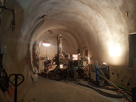
|
Storing CO2 underground (Carbon Capture and Storage CCS) is one technology among others that reduces emissions above ground and therefore supports the objectives of the Energy Strategy 2050. Once the CO2 is stored, it may escape through the borehole used to pump in the CO2 or through faults in the rock above the reservoir meant to seal it. Those faults might not only influence the long-term containment of CO2, but also the occurrence of induced micro-seismicity. The presence of faults in the capturing rock therefore strongly affects the site characterization process in terms of safety and risk assessment, monitoring, verification, and with respect to the risk management plan. To study these aspects, the Swiss Seismological Service and the SCCER-SoE conduct an experiment in close collaboration with the Department of Mechanical and Process Engineering and the Institute of Geophysics at ETH Zurich, with Swisstopo and EPFL, and with scientists from Norway, the Netherlands and the UK. The experiment is part of the ELEGANCY project, which is funded by the EU and the SFOE. The main goal of the experiment is to understand the relevant processes governing movement of stored CO2 along faults, the occurrence of micro-seismicity and to contribute to an enhanced site characterization. This involves experimental work at the Mont Terri rock laboratory, where the scientists inject CO2 enriched salt water into a borehole that cuts through a major fault and monitor how the fault reacts. |
|---|---|
| Project Leader at SED | Dr. Alba Zappone |
| Funding Source | Elegancy is a project financed by Norwegian, Dutch, German, UK and Swiss national funding agencies, the European Commission, and industry. |
| Duration | 31 August 2017–31 August 2020 |
| Keywords | Induced Seismicity, Carbon Capture and Storage |
| Research Field | Induced Seismicity, Swiss Seismicity, Earthquake Hazard & Risk, Earthquake Statistics, Earthquake Early Warning, Historical Seismicity, Seismotectonics, Real-time monitoring, Engi-neer Seismology, Other |
| Link To Project Website | |
| Publications |
Grab et al. (2022). Fluid pressure monitoring during hydraulic testing in faulted Opalinus Clay using seismic velocity observations. J. Geophys In print . Hopp, C., Guglielmi, Y., Rinaldi, A. P., Soom, F., Wenning, Q., Cook, P., Robertson, M., Kakurina M., Zappone A. (2021). The effect of fault architecture on slip behavior in shale revealed by distributed fiber optic strain sensing. Journal of Geophysical Research: Solid Earth. doi: 10.1002/essoar.10507120.1 Wenning Q., Madonna C., Kurotori T., Petrini C., Hwang J., Zappone A., Wiemer S., Giardini D., Pini R. (2021). Chemo-mechanical coupling in fractured shale with water and hydrocarbon flow. Geophysical Research Letters. doi: 10.1029/2020GL091357 Wenning Q., Madonna C., Zappone A., Grab M., Rinaldi A.P., Ploetze M., Nussbaum C., Giardini D., Wiemer S. (2021). Shale fault zone structure and stress dependant anisotropic permeability and seismic velocity properties (Opalinus clay, Switzerland). Journal of Structural Geology 144. doi: 10.1016/j.jsg.2020.104273 Zappone A. Rinaldi A.P., Grab M., Wenning Q., Roques C., Madonna C., Obermann A., Bernasconi S. M., Soom F., Cook P., Guglielmi Y., Nussbaum C., Giardini D., Wiemer S. (2021). Fault sealing and caprock integrity for CO2 storage: an in-situ injection experiment. Solid Earth Discussion. doi: 10.5194/se-2020-100 |
detect-µ
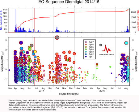
|
To a large part, the seismicity of Switzerland is characterized by swarm-like earthquake sequences of natural, and to a minor extent of man-made origin. Many of these sequences have been studied using relative location techniques, which often allowed to constrain the active fault plane of the larger events in a sequence and shed light on the tectonic processes that drive the seismicity. Yet, in the majority of cases the number of located earthquakes was too small to infer the details of the space-time evolution of the sequences, and their statistical parameters (e.g. magnitude-frequency distribution, Omori parameters). Therefore, it has been largely impossible to resolve clear patterns in the seismicity of individual earthquake sequences that are needed to improve our understanding of the mechanisms behind, and the differences between natural and induced earthquake sequences. In this project we aim to significantly improve the completeness of detected and located earthquakes in the Swiss catalog. We plan to develop techniques that take advantage of the waveform similarity in natural and induced earthquake sequences to detect seismic events several orders of magnitude below the detection threshold of classical signal energy based detectors. Waveform similarity will than further be exploited to derive accurate and consistent magnitudes and locations for even the smallest events of the sequences. Building on the data from this analysis we plan to study the processes and physics behind natural and induced microseismicity, e.g.:
|
|---|---|
| Project Leader at SED | Toni Kraft |
| SED Project Members | Marcus Herrmann, Stefan Wiemer |
| Funding Source | SED, Bundesamt für Energie |
| Duration | 2014-2016 |
| Keywords | Induced Seismicity, Real-time monitoring, Earthquake Statistics |
| Research Field | Induced Seismicity, Real-time monitoring, Earthquake Statistics |
| Publications |
Kraft, T., Diehl, T., Korger, E. and Tormann, T. (2014). Taking Surface Seismic Monitoring to the Nano-Seismic Scale: Results from Natural and Induced Seismic Sequences in Switzerland. AGU Fall Meeting Abstracts 1, 4552. |
Monitoring Geothermieprojekt Schlattingen
At the geothermal project Schlattingen/TG a borehole was sunk to 1.2km depth and stimulated with acid in early 2013. The Swiss Seismological Service monitored the acid stimulation with borehole and surface seismometers and in this way created a highly sensitive system for the detection of smallest fracture processes. The goal of the monitoring was to better understand the fundamental processes of a chemical stimulation, and to test if the analysis of tiny earthquakes can be used for the calibration of seismic hazard models to shorten the death times of traffic light systems. By comparing downhole and surface data, the performance of the different network and the attenuation of ambient seismic noise with depth will be investigated. In the framework of the project GEOBEST the results will be used to develop guidelines for the design of seismic monitoring networks. |
|
| Project Leader at SED | Toni Kraft |
|---|---|
| Funding Source | Bundesamt für Energie |
| Duration | 2013-2015 |
| Keywords | |
| Research Field | Induced Seismicity, Real-time monitoring, reservoir stimulation techniques |
GeoBest
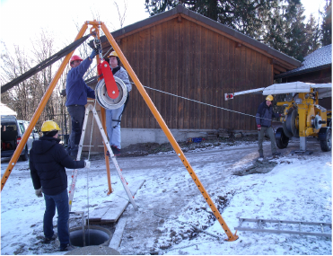
|
The processes and conditions underpinning induced seismicity associated with deep geothermal operations are still not sufficiently well understood to make useful predictions as to the likely seismic response to reservoir development and exploitation. The empirical data include only a handful of well-monitored EGS experiments; models are consequently poorly constrained. Unfortunately, datasets of well-monitored deep hydrothermal experiments are missing and empirical constraints of induced seismicity models for these cases do not exist. Given that the majority of the projects underway or planned in Europe are of the hydrothermal type, there is hope that this deficit can be remedied in the near future through a close cooperation of geothermal industry, science and public authorities. This is where the GeoBest project comes to play. By supporting selected pilot project for a limited time, SED facilitates the dialog with geothermal industry. Besides of the unique opportunity to collect high quality seismic data and being able to access relevant project data, gaining first hand practical experience in this field is of paramour importance for the development of significant best practice guidlines. |
|---|---|
| Project Leader at SED | Toni Kraft |
| SED Project Members | INDU group |
| Funding Source | Bundesamt für Energie |
| Duration | 2011-2015 |
| Keywords | Enhanced Geothermal System (EGS); Induced seismicity; High-precision hypocenter locations; Activated faults |
| Research Field | Induced Seismicity, Earthquake Statistics, Seismotectonics, Real-time monitoring |
| Publications |
Deichmann, N., Kraft, T. and Evans, K.F. (2014). Identification of faults activated during the stimulation of the Basel geothermal project from cluster analysis and focal mechanisms of the larger magnitude events. Geothermics 52, 84-97. doi: 10.1016/j.geothermics.2014.04.001 Diehl, T., Kraft, T., Kissling, E., Deichmann, N., Clinton, J. and Wiemer, S. (2014). High-precision relocation of induced seismicity in the geothermal system below St. Gallen (Switzerland). EGU General Assembly Conference Abstracts 16, 12541. Edwards, B., Kraft, T., Cauzzi, C., Kastli, P. and Wiemer, S. (2015). Seismic monitoring and analysis of deep geothermal projects in St Gallen and Basel, Switzerland. Geophys. J. Int. 201, 1020-1037. Evans, K.F., Zappone, A., Kraft, T., Deichmann, N. and Moia, F. (2012). A survey of the induced seismic responses to fluid injection in geothermal and CO2 reservoirs in Europe. Geothermics 41, 30-54. doi: 10.1016/j.geothermics.2011.08.002 Goertz, A., Riahi, N., Kraft, T. and Lambert, M. (2012). Modeling Detection Thresholds of Microseismic Monitoring Networks. 2012 SEG Annual Meeting. Society of Exploration Geophysicists. Kraft, T., Mignan, A. and Giardini, D. (2013). Optimization of a large-scale microseismic monitoring network in northern Switzerland. Geophysical Journal International 195, 474-490. doi: 10.1093/gji/ggt225 Kraft, T., Wiemer, S., Deichmann, N., Diehl, T., Edwards, B., Guilhem, A., Haslinger, F. et al. (2013). The ML 3.5 earthquake sequence induced by the hydrothermal energy project in St. Gallen, Switzerland. AGU Fall Meeting Abstracts 1, 3. Kraft, T. and Deichmann, N. (2014). High-precision relocation and focal mechanism of the injection-induced seismicity at the Basel EGS. Geothermics 52, 59-73. doi: 10.1016/j.geothermics.2014.05.014 Kraft, T. (2015). A high-resolution ambient seismic noise model for Europe. EGU General Assembly Conference Abstracts 16, 12407. Kraft, T. et al. (2015). Lessons learned from the 2013 ML3.5 induced earthquake sequence at the St. Gallen geothermal site. Schatzalp Workshop on Induced Seismicity, Davos, Switzerland. Obermann, A., Kraft, T., Larose, E. and Wiemer, S. (2015). Potential of ambient seismic noise techniques to monitor the St. Gallen geothermal site (Switzerland). J. Geophys. Res. Solid Earth 120(6), 4301–4316. doi: 10.1002/2014JB011817 Plenkers, K., Husen, S. and Kraft, T. (2015). A Multi-Step Assessment Scheme for Seismic Network Site Selection in Densely Populated Areas. Journal of Seismology 19(4), 861-879. |
GEOBEST
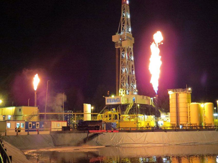
|
In recent years, the SED has been able to assist several Swiss deep geothermal energy projects in seismic monitoring, thus initiating a constructive dialogue with operators and cantonal authorities. Based on this experience, the SED has developed first recommendations for cantonal licensing and enforcement authorities on how to deal with the problem of induced seismicity in different phases of a deep geothermal project. However, these recommendations are based on experiences from only a few well-documented projects. The practical experience with their implementation has been largely missing in Switzerland so far. It is therefore difficult to predict how well these recommendations will be applicable in the local context (geological, political, cultural) and what adjustments may need to be made. Another important issue in this context is how guidelines and regulations from other technical or regulatory areas interact and are compatible with seismological recommendations for avoiding induced seismicity. Frequently, conflicts can only be identified and solved in the practical implementation of projects and through the close cooperation of the seismologist with approval authorities and operators. Equally important is the regular review and adaptation of all relevant policies and regulations based on the growing knowledge and experience. Whenever possible, this should be done in consensus with all stakeholders. In the project Geobest, the SED will continue to collect, evaluate and interpret basic data sets on the development of induced seismicity in deep geothermal projects in high quality and resolution. In addition, the SED can provide seismological advice and support to the cantonal and federal authorities in their licensing and monitoring obligations in all phases of a deep geothermal project. In this way, the SED wants to contribute to creating equal assessment standards for the environmental impact assessment across cantonal borders and, in the short to medium term, to standardize and thus considerably simplify and accelerate this process. A central website should inform the public independently, up-to-date and professionally on the subject of induced seismicity in order to support a substantive discussion of all interest groups. |
|---|---|
| Project Leader at SED | Dr. Toni Kraft |
| SED Project Members | Philippe Roth, Stefan Wiemer |
| Funding Source | |
| Duration | 2015-2019 |
| Keywords | Induced Seismicity, Induced Earthquake Hazard & Risk, Real-time monitoring, Support and consultancy |
| Research Field | Induced Seismicity, Induced Earthquake Hazard & Risk, Real-time monitoring, Support and consultancy |
| Link To Project Website | |
| Publications | |
| Reports / Deliverables |
Zbinden, D., Rinaldi, A. P., Diehl, T., & Wiemer, S. (2020). Potential influence of overpressurized gas on the induced seismicity in the St. Gallen deep geothermal project (Switzerland).. Solid Earth 11 (3), 909-933. doi: 10.5194/se-11-909-2020 Zbinden, D., Rinaldi, A. P., Diehl, T., & Wiemer, S. (2020). Hydromechanical Modeling of Fault Reactivation in the St. Gallen Deep Geothermal Project (Switzerland): Poroelasticity or Hydraulic Connection?. Geophysical Research Letters 47(3). e2019GL085201. doi: 10.1029/2019GL085201 Király‐Proag, E., Satriano, C., Bernard, P., & Wiemer, S. (2019). Rupture Process of the M w 3.3 Earthquake in the St. Gallen 2013 Geothermal Reservoir, Switzerland.. Geophysical Research Letters 46(14), 7990-7999. doi: 10.1029/2019GL082911 Kraft, T. & S. Wiemer (2019). GEOBEST-CH2 - Zwischenbericht II. Bericht des Schweizerischen Erdbebendienstes zu Händen des Bundesamtes für Energie, November 2018. Kraft, T. & S. Wiemer (2018). GEOBEST-CH2 - Zwischenbericht II. Bericht des Schweizerischen Erdbebendienstes zu Händen des Bundesamtes für Energie, November 2018. Kraft, T. & S. Wiemer (2017). GEOBEST-CH2 - Zwischenbericht I. Bericht des Schweizerischen Erdbebendienstes zu Händen des Bundesamtes für Energie, Dezember 2017. Kraft, T. & S. Wiemer (2017). GEOBEST-CH - Abschlussbereicht. Bericht des Schweizerischen Erdbebendienstes zu Händen des Bundesamtes für Energie, Oktober 2017. Link Wiemer, S., Kraft, T., Trutnevyte, E. and Philippe Roth (2017). “Good Practice” Guide for Managing Induced Seismicity in Deep Geothermal Energy Projects in Switzerland. Swiss Seismological Service at ETH Zurich. doi: 10.12686/a5 Kraft, T. & S. Wiemer (2016). GEOBEST-CH - Zwischenbericht II. Bericht des Schweizerischen Erdbebendienstes zu Händen des Bundesamtes für Energie, Dezember 2016. Kraft, T. & S. Wiemer (2015). GEOBEST-CH - Zwischenbericht I. Bericht des Schweizerischen Erdbebendienstes zu Händen des Bundesamtes für Energie, Dezember 2015. Kraft, T. & S. Wiemer (2015). Abschlussbericht, Projekt GEOBEST, Berichtszeitraum Okt. 2011 – Nov. 2015. Bericht des Schweizerischen Erdbebendienstes zu Händen des Bundesamtes für Energie, Dezember 2015. Link Kraft, T. & S. Wiemer (2015). Zwischenbericht IV, Projekt GEOBEST, Bericht des Schweizerischen Erdbebendienstes zu Händen des Bundesamtes für Energie, Dezember 2015. Kraft, T. & S. Wiemer (2014). Zwischenbericht III, Projekt GEOBEST, Bericht des Schweizerischen Erdbebendienstes zu Händen des Bundesamtes für Energie, November 2014. Kraft, T. & S. Wiemer (2012). Zwischenbericht II, Projekt GEOBEST, Bericht des Schweizerischen Erdbebendienstes zu Händen des Bundesamtes für Energie, September 2012. Kraft, T. & S. Wiemer (2011). Zwischenbericht I, Projekt GEOBEST, Bericht des Schweizerischen Erdbebendienstes zu Händen des Bundesamtes für Energie, August 2011. |
Noville Network
The Noville network is operated under a contract with Petrosvibri SA. The purpose of the network is to monitor induced seismicity related to a deep gas exploration drilling project near Noville, VD. |
|
| Project Leader at SED | Stephan Husen |
|---|---|
| SED Project Members | Toni Kraft |
| Funding Source | |
| Duration | 2009-2012 |
| Keywords | Induced Seismicity, Real-time monitoring, Engineer Seismology |
| Research Field | Induced Seismicity, Real-time monitoring, Engineer Seismology |
Brigerbad Network
The Brigerbad network is operated under a contract with Geothermie Brigerbad AG. The purpose of the network is to monitor induced seismicity related to the extraction of hot thermal waters from 400-600 m deep boreholes in Brigerbad, VS. |
|
| Project Leader at SED | Stephan Husen |
|---|---|
| SED Project Members | Toni Kraft |
| Funding Source | Geothermie Brigerbad AG |
| Duration | 2009-2011 |
| Keywords | Geothermie Brigerbad AG |
| Research Field | Induced Seismicity, Real-time monitoring |
Historical Seismology
Interdisciplinary Assessment of the Pre-instrumental and Early Instrumental Period of Systematic Earthquake Monitoring
|
The goal of this project is the historical-critical revision of the Swiss earthquake catalogue for the pre-instrumental and early instrumental period of systematic earthquake observations in Switzerland, 1878–1963, with a special focus on events of intermediate magnitude reaching epicentral intensities of IV–VI (EMS-98). To ensure correct interpretation of the large amount of heterogeneous scientific and non-scientific earthquake records, it is essential to investigate the historical, scientific and technological context of their production. This is achieved through the approaches of historical sciences. The proposed work relies on a systematic investigation and a historically sound assessment of the reliability and factuality of historically reported events. By the use of descriptive primary and secondary sources, macroseismic intensity fields will be established for intermediate-size earthquakes with an intensity in the range IV–VI (EMS-98). This will facilitate the assessment of event parameters such as magnitude, location and depth in a calibrated procedure that will be developed in the project. These parameters are verified by the analysis of the historical seismograms of the Swiss Seismological Service’s early instrumental station network. |
|---|---|
| Project Leader at SED | Prof. Donat Fäh |
| SED Project Members | Remo Grolimund |
| Funding Source | SNF |
| Duration | 2015-2019 |
| Keywords | Historical Seismology, Interdisciplinary, Historical Seismogram Analysis, Macroseismics, History of Science and Technology |
| Research Field | Swiss Seismicity, Earthquake Hazard & Risk, Historical Seismicity |
| Link To Project Website |
Lake sediments as archive of paleoearthquakes in Switzerland
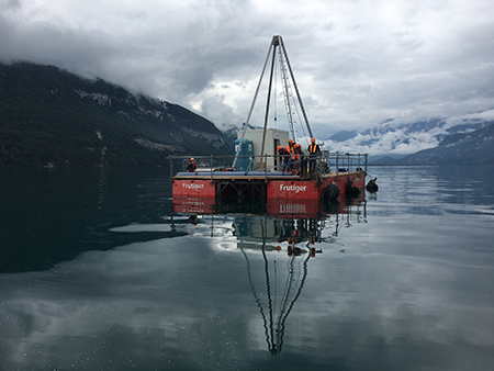
|
Earthquake can initiate subaquatic mass transport and sediment deformation structures, the deposits of which are stored in the sedimentary archive. Due to their good preservation potential and improving dating methods, these earthquake-related deposits in the sedimentary archive of lakes can extend the earthquake catalogue back to prehistorical times. The determination of frequency, epicentre and magnitude of these paleoearthquakes can be a key input for improving a probabilistic seismic hazard model, especially in areas such as Switzerland where strong earthquakes have long recurrence rates and might not be recorded in historic times. In order to better interpret the prehistorical earthquake-related sedimentary record, it remains important to understand which historical earthquakes did trigger mass transport deposits and sediment deformation structures, and which earthquakes did not trigger secondary sedimentary effects in the lake basins. The proposed project is aimed to improve our understanding of which earthquakes, or what kind of shaking, leave traces in the sediments, in order to evaluate the completeness of the sublacustrine paleoseismological record, using Lake Thun as example. The second aim of this project, directly linked to the first one, is to compare the paleoseismological record with the contemporary national seismic hazard model of Switzerland, updated in 2015. Thus, using the intensity ranges determined in the first part of this project and using the paleoseismic database of Switzerland a systematic analysis of frequencies, sources and magnitudes of possible paleoearthquakes will be compared to time series produced by the seismic hazard model of Switzerland. |
|---|---|
| Project Leader at SED | Dr. Katrina Kremer |
| Funding Source | SNF, Marie Heim-Vögtlin programme |
| Duration | 2.2017-1.2019 |
| Keywords | Lake sediments, paleoseismology, sublacustrine slope failure |
| Research Field | Historical Seismicity, Paleoseismology |
| Link To Project Website |
Historical Seismology 1912-1963: Ensuring the sustainability of interdisciplinary historical earthquake research at the SED
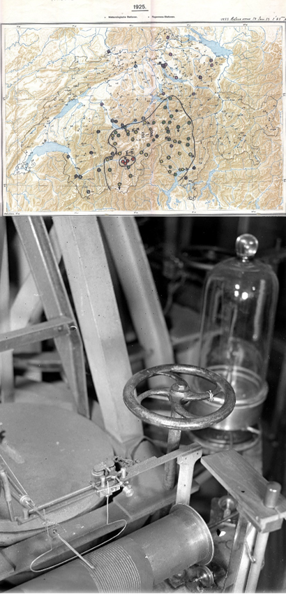
|
The assessment of seismic hazard in regions such as Switzerland are mainly based on historical documents due to the long return periods of medium to large earthquakes. During the last 20 years, seismologists, historians and database experts at the Swiss Seismological Service (SED) at ETH Zurich have been working together on a number of successful interdisciplinary projects. Within the framework of projects supported by the Swiss National Science Foundation, a wealth of data has been compiled covering information for the pre- and early instrumental period of scientific earthquake monitoring (1880-1963) . The compiled material consists of information collected using very different methods and covers both descriptive and early instrumental data. Due to the wealth of data and the challenges involved in recording and digitizing the very different types of sources, the potential of this data stock has not yet been exploited beyond the basic documentation and interpretation. This follow-up project, funded by the cogito foundation, serves to maintain the sustainability of the interdisciplinary historical research at the SED through in-depth and systematic analysis, documentation and publication activities. In the seismological domain, the improvement and interconnection of the macroseismic and instrumental data play an important role for the next revision of the earthquake catalogue of Switzerland. In the field of history of knowledge, the development of the SED in the first half of the 20th century can also be used as a data-supported historical case study on the conceptual, organizational and technological development of a scientific institution and its practices |
|---|---|
| Project Leader at SED | Prof. Donat Fäh |
| SED Project Members | Remo Grolimund |
| Funding Source | |
| Duration | 2020 - 2021 |
| Keywords | Historical Seismology, Interdisciplinary, Historical Seismogram Analysis, Macroseismics, History of Science and Technology |
| Research Field | Swiss Seismicity, Earthquake Hazard & Risk, Historical Seismicity |
Engineering Seismology
4D seismic response and slope failure
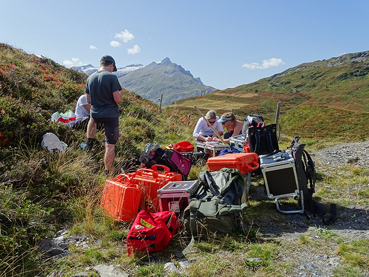
|
In the frame of this joint SNF and F.R.S-FNRS project with Belgium partners from the University of Liege, we study the highly variable seismic response of rock instabilities, and related slope failure potential of different mountain morphologies. Systematic ambient-vibration measurements at different rock slope instabilities with array-configurations allow to analyze the influence of layering and material of weathered rocks on the propagation of surface waves and amplification of ground motion. Normal mode vibrations can be observed on various rock structures with pronounced block structures. Application areas were selected in Belgium, Romania and Switzerland. A main goal of this project is to better understand the relation between wave-field properties like directivity, amplification, and eigenfrequencies, and geotechnical characteristics of rock slope instabilities. Additionally, the influence of weather and climate, as well as long-term changes in the dynamic response of the landslides are examined in detail using semi-permanent or permanent seismic stations. With such installations we study the vibrations of instabilities during earthquakes, which will help to develop models for earthquake induced mass movements. Experimental seismological techniques will be further developed with enhanced imaging capability and sensitivity. The expected results have the potential to be applied directly in hazard analysis and risk reduction measures. |
|---|---|
| Project Leader at SED | Prof. Donat Fäh |
| SED Project Members | Franziska Glüer |
| Funding Source | SNF |
| Duration | 2018-2022 |
| Keywords | Seismic hazard, earthquake induced effects, engineering seismology |
| Research Field | |
| Publications |
|
Nagra Station Characterization
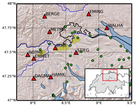
|
In cooperation with the National Cooperative for the Disposal of Radioactive Waste (Nagra), the Swiss Seismological Service has recently completed the installation of ten new seismological observation stations, three of them including a co-located borehole sensor. The ultimate goal of the project is to densify the existing Swiss Digital Seismic Network (SDSNet) in Northern Switzerland, in order to increase the sensitivity to very-low magnitude events and to improve the accuracy of future location solutions. This is strategic for unbiased monitoring of micro-seismicity at the places of proposed nuclear waste repositories. At each site, to further improve the quality and usability of the recordings, a full seismic characterization of the area surrounding the installation area was performed. The investigation consisted of a preliminary geological and geotechnical study, followed by an accurate seismic site response analysis by means of state-of-art geophysical techniques. For the borehole stations, in particular, the characterization was performed by combining different types of active seismic methods (refraction tomography, surface wave analysis, Vertical Seismic Profiling, VSP) with ambient vibration based approaches (wavelet decomposition, H/V spectral ratio, polarization analysis, three component f-k analysis). Results converged to the definition a unique summary velocity profile for the site, later used for the computation of the analytical SH-wave amplification function |
|---|---|
| Project Leader at SED | Donat Fäh |
| SED Project Members | Valerio Poggi |
| Funding Source | Nagra |
| Duration | 2012-2015 |
| Keywords | Site characterization, seismic stations |
| Research Field | Applied and engineering seismology |
| Publications |
Poggi, V., Keller, L. and Fäh, D. (2014). The new broadband seismic network in Northern Switzerland: Site characterization. Nagra Arbeitsbericht NAB, 15-54. Dal Moro, G., Keller, L. and Poggi, V. (2015). A comprehensive seismic characterisation via multi-component analysis of active and passive data. First Break 33(9), 45-53. |
| Reports / Deliverables |
Earthquake Physics Group
By means of theoretical and computational modeling, the research in Earthquake Physics Group aimed to cover the entire process of earthquakes: its source, radiation path, and ground motion at the surface. We performed both fundamental research on earthquake rupture dynamic processes and wave propagation and apply it for the development of physics-based models for ground motion prediction, seismic hazard assessment and earthquake engineering applications. Our main goal was to acquire a better understanding in the physics and mechanics of earthquakes. The research topics were:
Development of physics-based Ground Motion Prediction Equation Models (GMPE) |
|
| Project Leader at SED | Luis A. Dalguer |
|---|---|
| SED Project Members | Cyrill Baumann Alice Gabriel Percy Galvez Walter Imperatori Banu Mena Cabrera Seok Goo Song Ylona van Dinther Youbing Zhang |
| Funding Source | SNF CSCS, CCES-ETH, SCEC, Volksbankstiftung, 7th Framework Program of the European Commission |
| Duration | 2009-2014 |
| Keywords | Earthquake rupture dynamic, ground motion modeling, numerical simulation, friction models, earthquake cycles. |
| Research Field | Physics of earthquake, Earthquake seismology, engineering seismology, High Performance Computing |
| Publications |
Galvez, P., Dalguer, L.A., Ampuero, J.P. and Giardini, D. (2016). Slip reactivation during the 2011 Mw 9.0 Tohoku earthquake: Dynamic rupture and ground motion simulations. Bull. Seismol. Soc. Am., In press. Zhang, Y., Dalguer, L.A., Song, S.G., Clinton, J. and Giardini, D. (2015). Evaluating the effect of network density and geometric distribution on kinematic source inversion models. Geophys. J. Int. 200, 1-6. doi: 10.1093/gji/ggu252 Herrendoerfer, R., van Dinther, Y., Gerya, T.V. and Dalguer, L.A. (2015). Seismogenic zone downdip width controls supercycles at subduction thrusts. Nature Geoscience 8, 471–474. doi: 10.1038/ngeo2427 Galvez, P., Ampuero, J.P., Dalguer, L.A., Somala, S.N. and Nissen-Meyer, T. (2014). Dynamic earthquake rupture modeled with an unstructured 3D spectral element method applied to the 2011 M9 Toholu earthquake. Geophys. J. Int. 198, 1222–1240. doi: 10.1093/gji/ggu203 Baumann, C. and Dalguer, L.A. (2014). Evaluating the Compatibility of Dynamic-Rupture-Based Synthetic Ground Motion with Empirical GMPE. Bull. Seismol. Soc. Am. 104(2). doi: 10.1785/0120130077 van Dinther, Y., Gerya, T.V., Dalguer, L.A. and Mai, P.M. (2014). Modeling the seismic cycle in subduction zones: the role and spatiotemporal occurrence of off-megathrust earthquakes. Geophysical Research Letters 41(4), 1194–1201. Song, S.G., Dalguer, L.A. and Mai, P.M. (2013). Pseudo-dynamic source modeling with 1-point and 2-point statistics of earthquake source parameters. Geophys. J. Int. 196(3), 1770-1786. doi: 10.1093/gji/ggt479 Causse, M., Dalguer, L. A. and Mai, P.M. (2013). Variability of Dynamic Source Parameters Inferred from Kinematic Models of Past Earthquakes. Geophys. J. Int. 196(3), 1754-1769. doi: 10.1093/gji/ggt478 van Dinther, Y., Gerya, T.V., Dalguer, L.A., Mai, P.M., Morra, G. and Giardini, D. (2013). The seismic cycle at subduction thrusts: insights from seismo-thermo-mechanical models. J. Geophys. Res. Solid Earth 118(12), 6183–6202. doi: 10.1002/2013JB010380 Baumann, C., Burjanek, J., Michel, C., Haeh, D. and Dalguer, L.A. (2013). Fault zone signatures from ambient vibration measurements: a case study in the region of Visp (Valais, Switzerland). Swiss J. Geosci. 106, 529-541. doi: 10.1007/s00015-013-0155-3 Gabriel, A.A., Ampuero, J.P., Dalguer, L.A. and Mai, P.M. (2013). Source Properties of Dynamic Rupture Pulses with Off-Fault Plasticity. J. Geophys. Res. 118(8), 4117–4126. doi: 10.1002/jgrb.50213 Song, S.G. and Dalguer, L.A. (2013). Importance of 1-point statistics in earthquake source modeling for ground motion simulation. Geophys. J. Int. 192(3), 1255-1270. doi: 10.1093/gji/ggs089 van Dinther, Y, Gerya, T.V., Dalguer, L. A., Corbi, F., Funiciello, F. and Mai, P.M. (2013). The seismic cycle at subduction thrusts: 2. Dynamic implications of geodynamic simulations benchmarked with laboratory models. J. Geophys. Res. 118(4), 1502–1525. doi: 10.1029/2012JB009479 Mikhailov, V., Lyakhovsky, V., Panet, I., van Dinther, Y., Diament, M., Gerya, T.V., deViron, O. and Timoshkina, E. (2013). Numerical modelling of post-seismic rupture propagation after the Sumatra 26.12.2004 earthquake constrained by GRACE gravity data. Geophysical Journal International 194(2), 640-650. doi: 10.1093/gji/ggt145 Corbi, F., Funiciello, F., Moroni, M., van Dinther, Y., Mai, P.M., Dalguer, L.A. and Faccenna, C. (2012). The seismic cycle at subduction thrusts: 1. insights from laboratory models. J. Geophys. Res. 118(4), 1483–1501. doi: 10.1029/2012JB009481 |
Characterization of potential earthquake-triggered rock slope failures through ambient vibration analysis
In this ETHZ-funded project we analyze ambient vibrations and earthquake recordings to characterize and investigate the dynamic response of unstable rock slopes. We perform systematic measurements and interpretation of ambient vibrations at known unstable rock slopes, both with single stations and array-configurations. The eigenfrequencies, eigenmodes, directivity, and amplification of ambient vibrations are identified and compared to geotechnical investigations. The interpretation of recordings targets the estimation of the potential landslide volume and is supported by numerical modeling of seismic wave propagation in fractured media. A classification scheme based on the seismic response has been introduced, in which each class indicates specific properties of a rock instability. The two main classes found are volume-controlled sites and depth-controlled sites. The extensive database will be extended with instabilities on high-alpine permafrost locations. Moreover, both short-term and long-term monitoring is undertaken to understand the time evolution of the slope structure. Temporary monitoring stations are installed at the rock slope instabilities of Preonzo (Ticino) and Brienz (Grisons) and on a high-alpine permafrost ridge close to Gemsstock (Uri). A main goal of this monitoring is to understand the effect of weather and climate on the dynamic behavior of the rock and its stability, and to measure the slopes’ seismic response to earthquake ground motion. In a later stage of the project, the effect of earthquakes on the rock slope stability will be evaluated using numerical modelling. It will be evaluated, if ambient noise measurements can provide a direct proxy for the seismic vulnerability of rock slope instabilities. The expected results have the potential to be applied directly in hazard analysis and risk reduction measures. |
|
| Project Leader at SED | Donat Fäh |
|---|---|
| SED Project Members | Mauro Häusler |
| Funding Source | ETHZ |
| Duration | 2013–2021 |
| Keywords | Unstable rock slopes, ambient vibrations, ground motion modelling, landslides |
| Research Field | Seismic hazard, earthquake induced effects, engineering seismology, slope stability |
| Publications |
|
Advanced Single Station and Array Methods for the Analysis of Ambient Vibrations and Earthquake Recordings
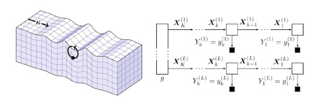
|
Within this project, new signal processing techniques for the analysis of ambient vibrations are developed. The focus is on the development of single-station methods and the adaptation of existing techniques to large arrays. Single-station methods represent an extremely valuable tool. The use of a single station further simplifies the measurement procedure thus enabling a more time and cost effective survey. Assumptions on the wavefield used when processing small arrays may be no longer valid when analyzing large arrays. For this reason, we investigate adaptations of existing techniques to large arrays. Target applications of the methods developed within this project include microzonation studies in Switzerland and investigation of the characteristics of the Swiss Molasse Basin. |
|---|---|
| Project Leader at SED | Prof. Donat Fäh
|
| SED Project Members | Stefano Maranò, Dario Chieppa (PhD) |
| Funding Source | SNF |
| Duration | Since 2014 |
| Keywords | Ambient vibrations, surface waves |
| Research Field | Earthquake Hazard & Risk, Signal Processing |
| Publications |
|
CTI Hydrocarbon Reservoir Detection by Interpretation of Microtremor Wavefields on Large Arrays
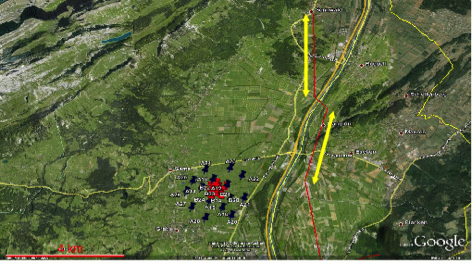
|
Hydrocarbon-bearing geological structures might cause characteristic modifications of the ambient vibration background noise. This question is addressed in a project supported by the Commission for Technology and Innovation (CTI) together with the company SpectraSeis. The link between observations and geological structure can only be made by understanding the wavefield that is recorded. This requires the simultaneous recording and analysis of ambient vibration wave-fields on arrays. Such methods have been developed in the past, and they have been applied to study soft-sediment surface deposits for seismic hazard analysis. The analysis of all three components of ground motion is addressed. Analysis of such recordings targets to distinguish between standing waves (global resonances) and propagating surface waves (Love- and Rayleigh-waves) as well as body waves (SH and PSV). By adapting array configurations during the measurements in the field, the identification of the wave-types with the corresponding propagation velocity and direction is optimized and allows to determine the source region of the waves and their possible origin. From the wave characteristics, structural information can be inverted that allows to improve structural models. The development of a real-time system for array measurements is part of the project. |
|---|---|
| Project Leader at SED | Donat Fäh |
| SED Project Members | Stefano Maranò, Javier Revilla |
| Funding Source | Commission for Technology and Innovation (CTI) |
| Duration | 2009-2012 |
| Keywords | Array methods, ambient vibration, hydrocarbon reservoir detection |
| Research Field | Strong-motion interpretation and site-effects, Signal Processing |
| Publications |
Maranò, S., Reller, C., Fäh, D. and Loeliger, H.-A. (2011). Seismic waves estimation and wave field decomposition with factor graphs. Proc. IEEE Int. Conf. Acoustics, Speech, and Signal Processing, 2748–2751. Prague, Czech Republic: IEEE. doi: 10.1109/ICASSP.2011.5947054 Reller, C., Loeliger, H.-A. and Maranò, S. (2011). Multi-sensor estimation and detection of phase-locked sinusoids. Proc. IEEE Int. Conf. Acoustics, Speech, and Signal Processing, 3872–3875. Prague, Czech Republic: IEEE. doi: 10.1109/ICASSP.2011.5947197 Maranò, S., Reller, C., Loeliger, H.-A. and Fäh, D. (2012). Seismic waves estimation and wave field decomposition: Application to ambient vibrations. Geophys. J. Int. 191, 175–188. doi: 10.1111/j.1365-246X.2012.05593.x Maranò, S. and Fäh, D. (2013). Processing of Translational and Rotational Motions of Surface Waves: Performance Analysis and Applications to Single Sensor and to Array Measurements. Geophys. J. Int. 196, 317-339. doi: 10.1093/gji/ggt18 Maranò, S., Fäh, D. and Lu, Y.M. (2014). Sensor placement for the analysis of seismic surface waves: sources of error, design criterion and array design algorithms. Geophys. J. Int. 197(3), 1566–1581. doi: 10.1093/gji/ggt489 |
| Presentations |
S. Maranò Seismic wave field decomposition application to the analysis of ambient vibrations. European Seismological Commission 32nd Assembly, September 6-10 2010, Montpellier, France. S. Maranò Seismic Waves Estimation and Wave Field Decomposition With Factor Graphs. IEEE International Conference on Acoustics, Speech, and Signal Processing, May 22-27 2011, Prague, Czech Republic. S. Maranò Maximum likelihood parameter estimation for surface waves: application to ambient vibrations. 4th International IASPEI/IAEE Symposium on the Effects of Surface Geology on Seismic Motion, August 23-26 2011, Santa Barbara, California. S. Maranò Maximum Likelihood wavefield parameters estimation: Application to the analysis of ambient vibrations. European Seismological Commission 33rd Assembly, August 19-24 2012, Moscow, Russia. S. Maranò Joint processing of translational and rotational motions of seismic surface waves: Performance analysis and applications. IASPEI Assembly, July 12-26 2013, Gothenburg, Sweden. Invited presentation. S. Maranò Analysis of ambient vibrations using a maximum likelihood method. European Seismological Commission 34th Assembly, August 24-29 2014, Istanbul, Turkey. |
SNF 2011 Source and Site-effect Studies for Probabilistic Seismic Hazard Assessment in Switzerland
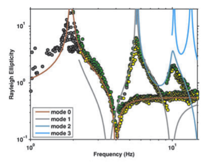
|
The project includes the work of two PhD candidates, addressing practical problems related to source characterization (Falko Bethmann) and site-effect assessment (Valerio Poggi). In the first part of this PhD project, scaling relations between small and large earthquakes are developed and the potential impact of such relations on estimating maximum near-fault ground motions is studied. In the second part of the project, new techniques for site characterization and site response analysis are implemented. First, a new method to analyze three component array recordings of ambient vibration is developed that allows retrieving the ellipticity functions of the different Rayleigh-wave modes. Subsequently, a procedure to combine passive (ambient vibration) and active-source techniques is proposed, with the goal to improve resolution of array measurements on shallow layers from high frequency component of the wave-field. Finally, generic amplification functions are developed for a common reference condition in Switzerland that serve as input for site-specific seismic hazard assessment. |
|---|---|
| Project Leader at SED | Donat Fäh |
| SED Project Members | Valerio Poggi, Falko Bethmann, Nico Deichmann |
| Funding Source | SNF |
| Duration | 2006-2010 |
| Keywords | Seismic source characterization, site-effects |
| Research Field | Applied and engineering seismology |
| Publications |
Poggi, V. and Fäh, D. (2010). Estimating Rayleigh wave particle motion from three-component array analysis of ambient vibrations. Geophys. J. Int. 180(1), 251-267. doi: 10.1111/j.1365-246X.2009.04402.x Poggi, V., Edwards, B. and Fäh, D. (2011). Derivation of a Reference Shear-Wave Velocity Model from Empirical Site Amplification. Bull. Seim. Soc. Am. 101(1), 258-274. doi: 10.1785/0120100060 Poggi, V., Fäh, D. and Giardini, D. (2012). T-f-k analysis of surface waves using the continuous wavelet transform. Pure and Applied Geophysics 170(3), 319-335. Poggi, V., Fäh, D., Burjanek, J. and Giardini, D. (2012). The use of Rayleigh wave ellipticity for site-specific hazard assessment and microzonation. An application to the city of Luzern (Switzerland). Geophys. J. Int. 188(3), 1154-1172. doi: 10.1111/j.1365-246X.2011.05305.x |
Renewal of the Swiss Strong Motion Network (SSMNet) – Phase 2
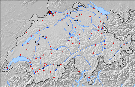
|
Since 2009, the Swiss Seismological Service is renewing and expanding its strong motion network. During the first phase, a total of 30 new accelerometer stations have been installed between 2009 and 2013, both replacing existing strong motion dial-up stations and installing new stations. During the ongoing second phase, 70 more stations are planned to be installed by 2020, including four borehole installations. The renewal project of the Swiss Strong Motion Network was approved by the Swiss Federal Council in February 2009. The project is monitored and supervised by a steering committee headed by the Swiss Federal Office for the Environment (FOEN). The goals of the enlargement of the Swiss strong motion network are a better spatial coverage of earthquake-prone regions, a better understanding of site effects and thus the verification and improvement of hazard models. The epicentral areas of relevant past earthquakes have been instrumented in the first phase, namely Aigle (1584), Glarus (1971), Sarnen (1964), Sion-Sierre (1946), Yverdon (1929), Visp (1855), St. Gallen Rhine Valley (1796/96), Altdorf (1774), Brig (1755), Basel (1356), Churwalden/Vaz (1295/1991), etc. Furthermore, the city areas of Zürich, Geneva, Basel, Bern, Lausanne, St. Gallen, Lucerne, Sion, Solothurn, Locarno, Chur, Sierre are relevant sites for free-field installation. In the second phase, additional epicentral areas of past earthquakes are targeted: Churwalden (1295), Ardez (1504), Ardon (1524), Arbon (1720), Kreuzlingen (1911), and Moudon (1933), among others. Further urban areas are instrumented as well, e.g. Biel, Fribourg, Neuchâtel, Thun and Winterthur. Another aspect of phase 2 is the densification of the network, especially in earthquake-prone areas such as the Valais. The site selection is always a trade-off between the scientific objectives and the level of vibration disturbances. Modern stations are sensitive enough to record also small earthquakes, but the signal-to-noise ratio may be too low due to traffic and industries. At all sites, geophysical measurements are performed to characterize the site response. Recorded signals can then be interpreted, and sites classified according to the amplification at the site, which is basic information for improved site-specific seismic hazard studies. |
|---|---|
| Project Leader at SED | Prof. Donat Fäh |
| SED Project Members | Manuel Hobiger, Eric Zimmermann, Clotaire Michel, Franz Weber, Lukas Heiniger, John Clinton, Carlo Cauzzi |
| Funding Source | BAFU |
| Duration | 2013-2020 |
| Keywords | SSMNet, strong motion, site characterization |
| Research Field | Swiss Seismicity, Earthquake Hazard & Risk |
| Publications |
|
Spektrum – an ETH spin-off project
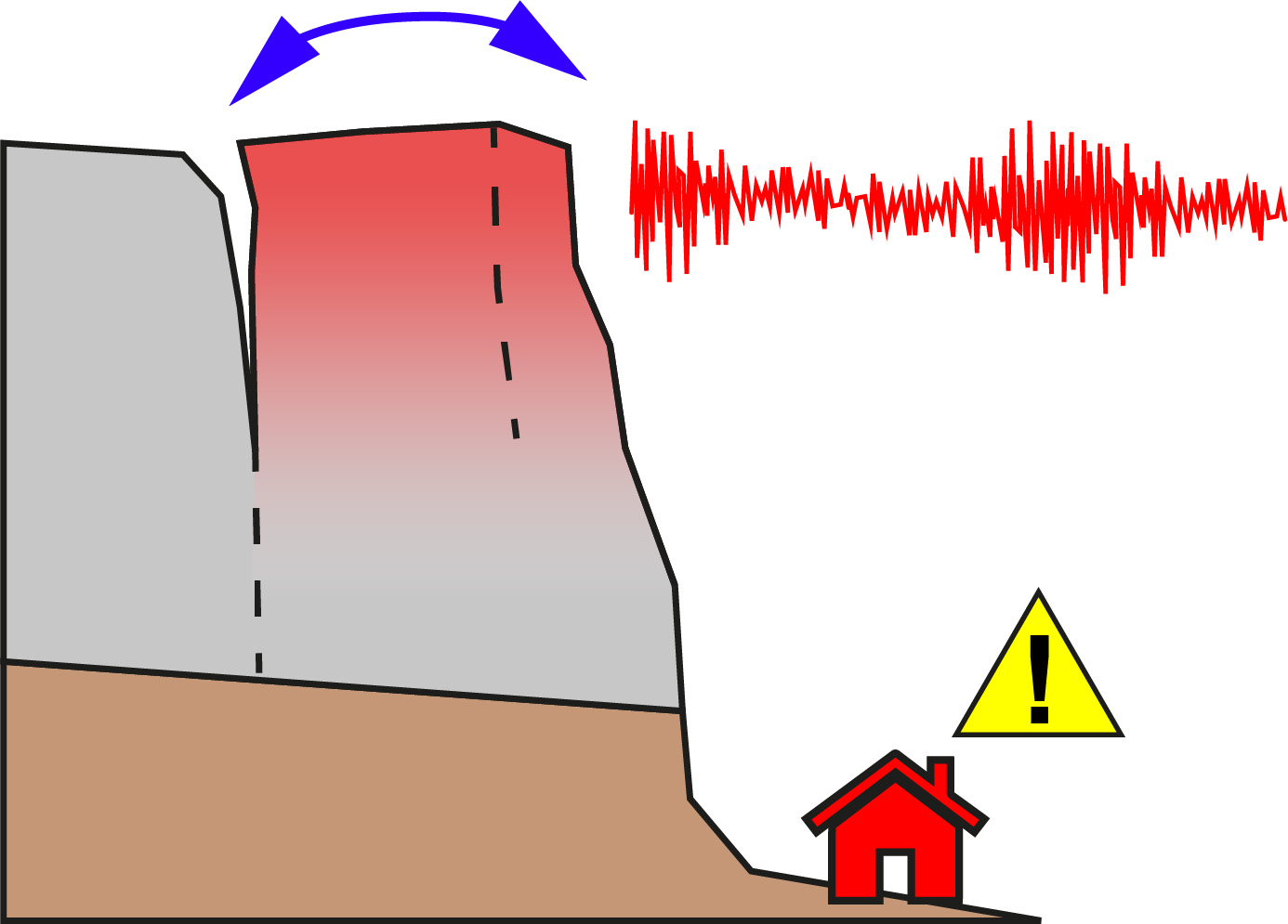
|
Spektrum is an ETH Zurich project to translate geophysical techniques for landslide monitoring developed in the section for Engineering Seismology at the into a practical product to solve real-world problems. Most information available for characterizing and monitoring unstable rock slopes are acquired by sensing displacements at the Earth’s surface, possibly missing critical structural changes at depth. We provide a solution to overcome this gap by measuring ambient vibrations on potentially unstable slopes and rock features. The vibrational properties provide information on the extent of the instability and the degradation of the rock mass – similar to structural health monitoring of large bridges and dams. The technique can be applied for real-time monitoring but also by using temporary and portable sensors for rapid characterization of the slope as a base for in-depth geological investigations. The Pioneer Fellowship is supported by the ETH Foundation and the Innovation & Entrepreneurship Lab of ETH Zurich. |
|---|---|
| Project Leader at SED | Mauro Häusler |
| Funding Source | ETH Foundation |
| Duration | 2022 - 2023 (18 months) |
| Keywords | Ambient vibrations, landslides, rock slope instabilities |
| Research Field | Engineering Seismology, Real-time monitoring |
| Link To Project Website |
Earthquake-induced Phenomena
Automatic Avalanche, Landslide and Rockfall Detection in the Swiss Alps Based on their Seismic Signatures
|
The reliable detection of snow avalanches, landslides and rockfall provides the basis for any advanced investigation on triggering mechanisms, risk assessment or the identification of possible precursors. It is well known that such phenomena produce specific seismic signals. Nonetheless, the manual detection on seismic traces is not feasible since it is extremely time consuming and results are influenced by the subjective view of the analyst. Automatic detection is therefore preferred, as unbiased results are obtained in near real-time. In this project, we will take advantage of an automatic classification procedure for continuous seismic signals to detect avalanches, landslides and rockfalls in continuous streams of seismic data. The applied method is independent of previously acquired data and classification schemes, offering the opportunity to detect very rare and highly variable events. The goal of this project is to improve the detection across the entire Swiss Alps and to better understand possible triggering mechanisms. In addition accurate information on the number and release time of avalanches will provide an important contribution to the avalanche warning service at the SLF. This research is highly relevant since large scale avalanche and landslide monitoring will provide reliable data for further research, the development of near real-time products and improved risk assessment and warning systems. |
|---|---|
| Project Leader at SED | Prof. Donat Fäh |
| SED Project Members | Conny Hammer |
| Funding Source | SED, WSL |
| Duration | since 2015 |
| Keywords | snow avalanches, landslides, rockfalls, automatic detection, monitoring |
| Research Field | real-time monitoring, avalanche and landslide detection |
| Publications |
|
TSUNAMI-CH Phase 2: Including delta failures and subaerial mass movements in the workflow for assessing the lake tsunami hazard
|
Tsunamis do not only happen in oceans, but they do also occur in lakes. As part of an interdisciplinary project entitled “Lake Tsunamis: Causes, Consequences and Hazard” (2017-2021), a workflow for the assessment of the tsunami potential on peri-alpine lakes was developed. The workflow focuses on the tsunami generation by subaqueous mass movements. However, it has been documented that delta failures have caused considerable tsunamis on peri-alpine lakes. So far, delta failures have been widely neglected in the assessment of lake tsunamis; mainly as the triggering and failure mechanisms have not been investigated in detail, and as important parameters such as the thickness and failure volumes are not known. WP delta will characterize various deltas in Swiss peri-alpine lakes, and identify the ones that are susceptible to failure. The resulting geodatabase will store various delta parameters that are relevant for estimating the tsunami potential. WP wave simulation extends the workflow for the modelling of the tsunami generation, propagation and inundation that was developed in the preceding project. Numerical modelling is conducted with BASEMENT, a freeware simulation tool for hydro- and morphodynamic modelling developed at VAW. WP Synthesis will document the comprehensive workflow for the assessment of the tsunami hazard. |
|---|---|
| Project Leader at SED | Michael Strupler, Stefan Wiemer |
| SED Project Members | Michael Strupler, Stefan Wiemer |
| Funding Source | Federal Office for the Environment FOEN |
| Duration | 2022-2023 |
| Keywords | Lake tsunami, delta failures, subaerial mass movements, Tsunami hazard, Swiss Lakes, FOEN |
| Research Field | Earthquake Hazard & Risk |
| Link To Project Website |
Statistical Seismology
Calibrating an Indicative Stress-meter for the Earth’s Crust
|
Recent discoveries include: Non-volcanic tremors (NVT), strong heterogeneity of the relative stress distribution, temporal and along-fault variable aseismic creep, repeating earthquakes, slow slip events. Based on the insight that was gained from these previous studies, we will be able to develop and calibrate an indicative stress-meter for the Earth’s crust. In this project we link for the first time the statistical analysis of the size distribution of earthquakes with complementary observations of fault movement. This yields an improved understanding of the nature of fault loading cycles. Therefore, the results will provide key understanding to unravelling the predictability of earthquakes and has the potential to radically change the assessment of local seismic hazard for selected well-understood and well-monitored faults. |
|---|---|
| Project Leader at SED | Prof. Stefan Wiemer |
| SED Project Members | Nadine Staudenmaier, Dr. Thessa Tormann |
| Funding Source | SNF |
| Duration | 2013 - October 2018 |
| Keywords | Non-volcanic tremors (NVT), strong heterogeneity of the relative stress distribution, slow slip events |
| Research Field | Earthquake Statistics, Seismotectonics |
Database for design-compatible waveforms
In the frame of the project Database for design-compatible waveforms, we determine the magnitude-distance scenarios most relevant for the five seismic zones (Z1a, Z1b, Z2, Z3a and Z3b) defined in the Swiss building code SIA261 (2020) through disaggregating of the seismic hazard for return periods of 475 and 975 years. We inspect available worldwide databases of waveforms and related metadata, and define standards linked to the quality of three-component recordings (compatibility to GMPE, adequate frequency content, absence of non-physical drift in velocity and displacement) and quality of metadata (reliability of magnitude, distance, site condition information, free-field recording, etc.). Finally, following rules in Eurocode8, we select and scale waveforms for the different soil classes defined in the Swiss building code and each seismic zone. |
|
| Project Leader at SED | Prof. Donat Fäh |
|---|---|
| SED Project Members | Paolo Bergamo, Danciu Laurenciu, Francesco Panzera |
| Funding Source | Federal Office for the Environment (FOEN) |
| Duration | Start 1.9.2020 (3 years) |
| Keywords | Seismic hazard disaggregation; response spectra; building code SIA261; strong motion waveforms |
| Research Field | Engineering Seismology |
| Publications |
|
Earthquake Precursors
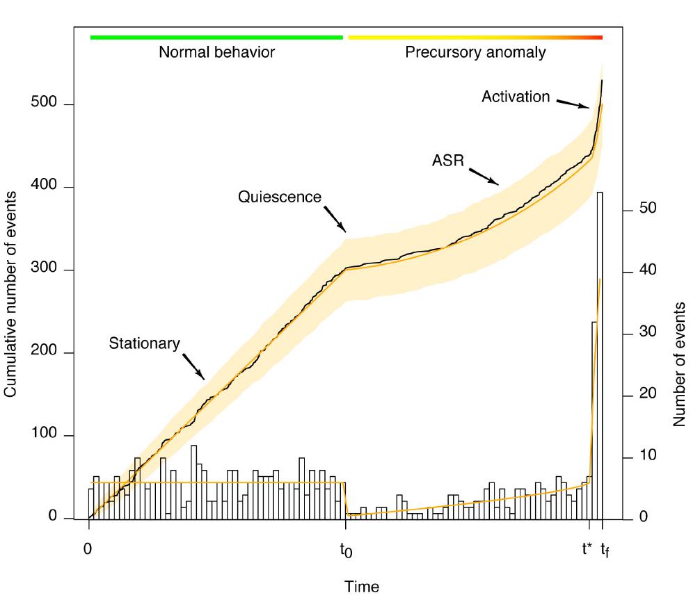
|
Our present knowledge about earthquakes does not yet allow us to reliably forecast earthquakes. Therefore, the study of precursors is an essential step in the direction of earthquake forecasting. Precursors can be anomalous seismic patterns or other phenomena such as peculiar animal behavior, or electromagnetic anomalies etc., which indicate the incidence of a large event. We focus in our studies on seismic precursors, namely quiescence, which is expressed through reduced seismic activity, accelerated seismicity (ASR) and short term foreshocks. The mentioned precursors are observed in many selected earthquake sequences in the past. However, there is skepticism if these precursors happen systematically; some studies explain their occurrence rather as a random temporary perturbation of normal seismicity which is accidentally followed by a large earthquake. We believe that systematic investigations on the occurrence of precursors give essential evidence for or against their existence. We chose to perform these investigations with statistical tools, hence by evaluating location, time and magnitudes of earthquakes from several regional earthquake catalogs of the world, to obtain representative precursor statistics. We find that small earthquakes, as they occur more frequently, could facilitate the detection of precursory patterns (Mignan, 2014). We study statistical models used to describe earthquake occurrence and the impact of the choice of the lowest magnitude on them (Seif et al, 2016, submitted). Using these models we evaluate if foreshock occurrence differs from normal seismicity. We also want to specify how often foreshock patterns are followed by large events or not (true/false alarm rate). In the future remaining precursory patterns, quiescence and accelerated seismicity, will be investigated in the same way. We hope that the statistical analysis will allow us to better understand the physical processes which lead to the occurrence of precursors. |
|---|---|
| Project Leader at SED | Dr. Arnaud Mignan |
| SED Project Members | Stefanie Seif, Dr. Jeremy Zechar, Prof. Stefan Wiemer |
| Funding Source | ETH Grants |
| Duration | 2013 - August 2018 |
| Keywords | Precursors, foreshocks, cut-off magnitude, ETAS |
| Research Field | Earthquake Statistics, Earthquake Forecasting |
| Publications |
|
DELAYED NEWZ
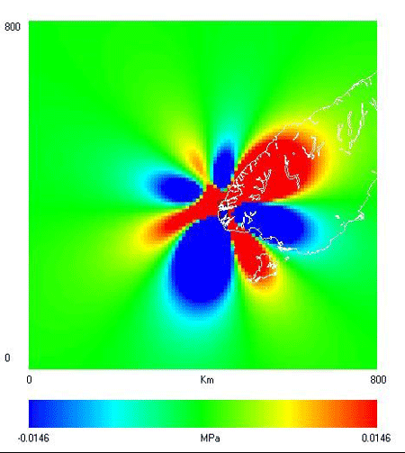
|
Quantifying time-varying seismicity rates is fundamentally important to protecting people who live in areas subject to extreme earthquake shaking. One primary difficulty with such assessment is determining how faults interact. Some recent studies have noted the ability of passing earthquake waves to increase the 'triggerability' of a fault in a delayed form of dynamic stressing: after seismic waves pass, faults are more prone to fail in a subsequent earthquake. The deadly Canterbury earthquake sequence has characteristics that suggest it was promoted by such distant, delayed, dynamic triggering. The sequence is also compatible with a model in which low-strain rate areas are efficient at storing and transferring static stresses. This has implications for earthquake clustering and the generation of damaging ground motion. We will apply recently-developed techniques in concert to address three questions: 1) Can we quantify distant and delayed triggering in this sequence? We will address this by correlating increased geodetic crustal velocities in Canterbury following the 2009 M7.8 Dusky Sound earthquake that occurred hundreds of km away. We will apply source scanning and template matching techniques to search Canterbury for microseismicity that was triggered by the M7.8 event. 2) Do earthquakes in low-strain rate areas exhibit more clustering and longer aftershock sequences than their high-strain rate counterparts, and do these earthquakes produce stronger ground motions? We will build a comprehensive model of earthquake generation in low-strain rate areas by using an earthquake simulator to model the evolution of the sequence. 3) Can the simulator model we develop demonstrate skill in seismicity forecast experiments? The model developed in this project could provide a true step change and bring seismology closer to bridging the gap between probabilistic forecasting and deterministic modelling of earthquake hazard. |
|---|---|
| Project Leader at SED | Prof. Stefan Wiemer |
| SED Project Members | Yifan Yin |
| Funding Source | ETH |
| Duration | 2015-2019 |
| Keywords | Delayed dynamic triggering; earthquake physics; earthquake simulator; earthquake forecasting |
| Research Field | Earthquake Hazard & Risk, Earthquake Statistics |
CORSSA: Community Online Resource for Statistical Seismicity Analysis
|
Statistical seismology is the application of rigorous statistical methods to earthquake science with the goal of improving our knowledge of how the earth works. Within statistical seismology there is a strong emphasis on the analysis of seismicity data in order to improve our scientific understanding of earthquakes and to improve the evaluation and testing of earthquake forecasts, earthquake early warning, and seismic hazards assessments. Given the societal importance of these applications, statistical seismology must be done well. Unfortunately, a lack of educational resources and available software tools make it difficult for students and new practitioners to learn about this discipline. The goal of the Community Online Resource for Statistical Seismicity Analysis (CORSSA) is to promote excellence in statistical seismology by providing the knowledge and resources necessary to understand and implement the best practices. CORSSA covers a wide variety of themes: Introductory Material Each of these themes includes a series of articles that are listed in the CORSSA Table of Contents. The series of themes was devised to make it easy for the reader to focus on their personal requirements to get an introduction to statistical seismology, or to learn about the basics of earthquakes, statistics, and/or the intricacies of seismicity catalogs before moving onto applications. |
|---|---|
| Project Leader at SED | Dr. J. Douglas Zechar |
| SED Project Members | Stefan Wiemer |
| Funding Source | |
| Duration | 2011-present |
| Keywords | Statistical seismology, aftershocks, declustering |
| Research Field | Earthquake Hazard & Risk, Earthquake Statistics |
| Publications |
|
Numerical modelling
Ground Motion Modeling in Complex Structures
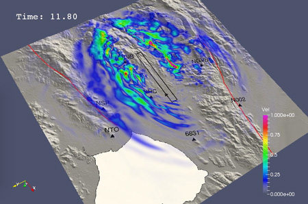
|
This is the 2nd subproject of the „ENSI – SED-Erdbebenforschung zu Schweizer Kernanlagen“ project. Realistic modeling of earthquake ground motions can be achieved only if the causative fault and the medium where waves propagate are described accurately. To efficiently simulate high-frequency earthquake scenario in Switzerland, we develop a hybrid broadband simulation technique combining state-of-the-art rupture models along irregular fault surfaces and wave propagation in complex heterogeneous media taking into account station-specific scattering parameters. Significant efforts are made to extend the validity of our technique to model ground motion at depth for possible applications at underground repositories. A thorough validation and calibration of sensitive parameters is based on Japanese and Swiss datasets. Along with source and path effects, near-surface site conditions represent an important factor controlling ground motions since soft sediments can significantly amplify the shaking observed during an earthquake. Depending on the level of input ground motion, liquefiable soils have the potential to generate excess water pressure resulting in high-frequency acceleration pulses. Advanced constitutive models of liquefiable soils require the knowledge of so-called dilatancy parameters that describe the potential to generate excess water pressure. These parameters can be determined from field observations by analyzing cone penetration test (CPT) measurements. Accurate modeling of liquefiable soils subject to high-amplitude Mach waves is essential to explore the physical limits of ground motion. |
|---|---|
| Project Leader at SED | Prof. Donat Fäh |
| SED Project Members | Walter Imperatori |
| Funding Source | Swiss Federal Nuclear Safety Inspectorate – ENSI |
| Duration | 2010-2014 (1st phase), 2014-2018 (2nd phase), 2018-2022 (3rd phase) |
| Keywords | Ground motion, scattering, hybrid broadband, non-linearity, site effects, CPT |
| Research Field | Engineering Seismology |
| Publications |
|