Frequently Asked Questions (FAQ)
Earthquake Causes and Processes
Earthquakes are generated when tensions built up due to relative movement between rocks along faults are suddenly released. The seismic energy from these events travels through the Earth in the form of waves and causes the tremors observed as earthquakes.
Earthquakes are caused by a sudden release of stress along faults in the Earth's crust. The continuous motion of tectonic plates causes a steady build-up of pressure in the rock strata on both sides of a fault until the stress is sufficiently great that it is released in a sudden, jerky movement. The resulting waves of seismic energy propagate through the ground and over its surface, causing the shaking we perceive as earthquakes.
Earthquakes can also be linked to volcanic activity.
Human activity like tunnel construction, filling reservoirs and implementing geothermal or fracking projects can trigger earthquakes, too (see the question "What are induced earthquakes?").
Learn more
Detailed explanation of the causes of earthquakes worldwide

Earthquakes in Europe are essentially a result of stress in the earth’s crust. For naturally occurring earthquakes, the source of this stress is plate tectonics. The Eurasian plate encompasses much of Europe’s and Asia’s mainland, and moves with respect to the main neighbouring plates in the South (African plate), Southeast (Anatolian microplate), and West (North-America plate). In addition, there are a number of microplates between Europe and Africa. These make the tectonic picture particularly complex around the Mediterranean Sea including the Alpine region. Because of the microplates, earthquakes in Europe occur across a large area, not only along a well-defined zone.
Greece and Turkey share the highest seismic hazard in the European region.
These are the six main earthquake zones in Europe:
- Greece (African plate)
- Turkey (Anatolian microplate)
- Iceland (North-America plate)
- Italy, Switzerland, Austria, Slovenia, Germany, and France (Adriatic microplate)
- Hungary, Slovakia, Ukraine, and most of the Balkan peninsula (Pannonian Basin and surrounding mountains)
- Spain and Portugal (Iberian microplate)
Learn more
Detailed explanation of the six main earthquakes zones in Europe
Earthquake Hazard Map of Europe (Danciu et al. 2021)

Induced earthquakes are earthquakes caused by human activity.
In Switzerland, man-made quakes occur mainly in connection with geothermal energy projects. In 2006, an earthquake with a magnitude of 3.4 was triggered in Basel by water being injected at high pressure into the ground. A 3.5 magnitude earthquake was also triggered near St. Gallen in 2013.
But earthquakes are also triggered when the subsoil is breached for other reasons, such as when injecting CO2 or wastewater, during conventional and non-conventional extraction of crude oil and natural gas through fracking, or in mining and tunnelling. Furthermore, man-made alterations to the earth’s surface can also trigger earthquakes, for example when filling reservoirs with water for the first time.
Learn more
Man-made Earthquakes
Explore the causes of man-made earthquakes by clicking on the black circles:

Faults are underground tectonic ruptures along which rocky masses move in relation to one another. This movement can be convergent (towards each other, as in the Andes), divergent (away from each other, e.g. mid-ocean ridges) and/or transformational (horizontal sideways movement, like in the San Andreas fault).
The fault plane, which may be horizontal, vertical, slightly inclined, or some other variant, can range from a few centimetres to several hundred kilometres in size and involve rock masses or entire crustal sections grinding against each other.
Any fault along which one or more earthquakes have taken place within the past 10,000 years is said to be active (USGS, 2011).
When an earthquake occurs, usually only a section of the fault shifts. This is referred to as the fracture surface, and within it lies the hypocentre of an earthquake (Weidmann, 2002). In principle, the larger the fracture surface underground and the more it shifts, the stronger the earthquake will be.
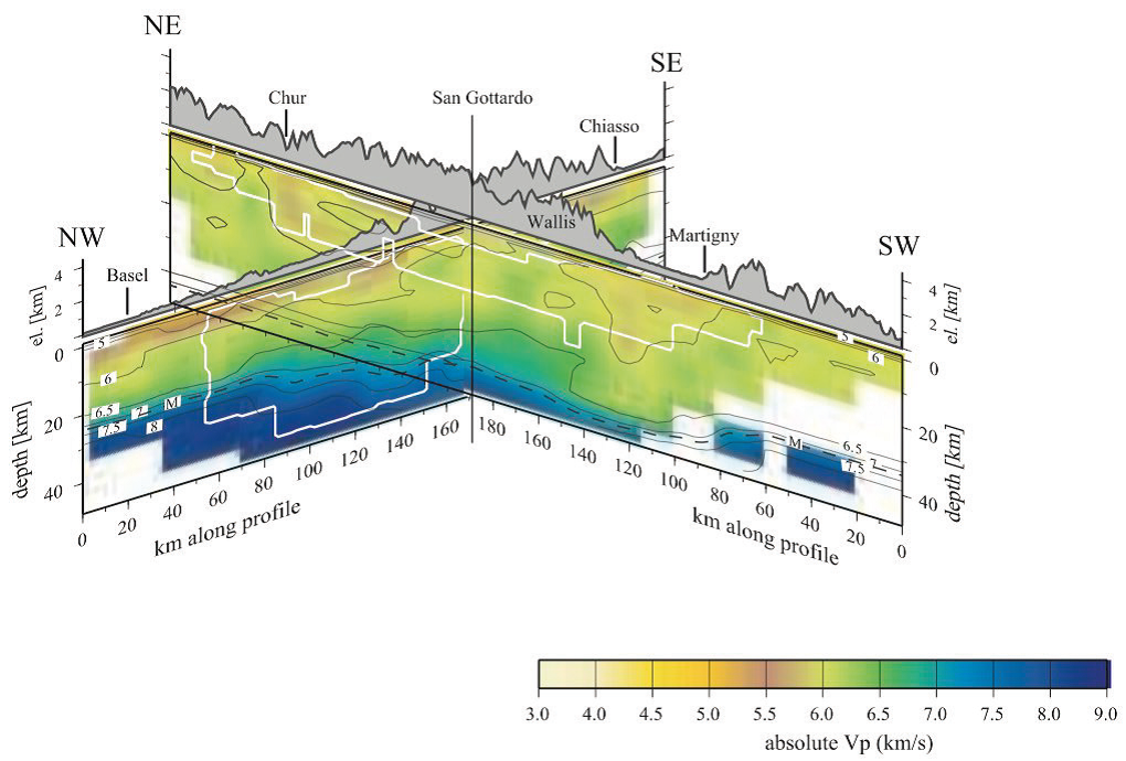
Almost all earthquakes occur in the outer layer of our planet, i.e. in the Earth's crust. In the foothills of northern Switzerland the crust is roughly 30 kilometres thick, whereas in the Alps it is up to 50 kilometres thick. Beneath it lies the Earth's mantle. The transition between the crust and the mantle is referred to as the Moho. In the northern foothills of Switzerland, earthquakes occur right the way down to the Moho, whereas in the Alps seismic activity is limited to roughly the upper 15 to 20 kilometres of the Earth's crust.
In Switzerland, we talk of a shallow earthquake when the hypocentre lies less than 10 kilometres beneath the surface. As a rule, such near-surface earthquakes tend to be felt by people and cause more damage than deeper quakes.
Vertical cross section through Switzerland documenting the depth distributions of earthquakes

The seismic energy released by an earthquake courses through the Earth in the form of waves that cause the tremors experienced as earthquakes at the surface. These waves can be measured by seismometers (see the question "What is a seismometer and how does it work?").
Seismic waves can be divided into two main types: body waves (P and S waves) and surface waves (Love and Rayleigh waves).
The hypocentre and epicentre of an earthquake can be calculated because these seismic waves are propagated at different velocities (see the questions "What is a hypocentre?", "What is an epicentre?" and "How is an earthquake's place of origin determined?").
- P waves
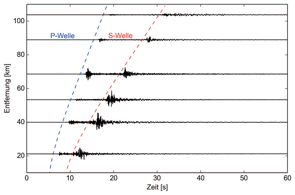
P waves (primary waves) are propagated spherically from the hypocentre in the form of body waves (see the question "What is a hypocentre?") and spread by alternatively pushing (compressing) and pulling on the geological substrate.
The propagation velocity of P waves varies between roughly 6 and 8 km/s, depending on the rock strata through which they pass. Being the fastest seismic waves, P waves are the first to reach seismic stations.
- S waves
S waves (secondary waves) also propagated spherically from the hypocentre in the form of body waves (see the question "What is a hypocentre?") and spread by moving the particles of rock through which they pass perpendicularly to their direction of travel, either horizontally (from side to side) or vertically (up and down).
S waves spread through any rock strata at a propagation velocity of roughly 3 to 4 km/s and therefore always reach seismic stations after P waves.
- Love waves
Love waves are surface waves propagated from the epicentre (see the question "What is an epicentre?"). They are produced when P and S waves reach the surface. Love waves move rock parallel to the surface of the Earth (horizontally, from side to side).
Love waves are slower than S waves but faster than Rayleigh waves.
- Rayleigh waves
Rayleigh waves are also surface waves propagated from the epicentre (see the question "What is an epicentre?") and are likewise produced when P and S waves reach the surface. Rayleigh waves roll with an elliptically rotating motion, rather like the ripples caused when a stone is thrown into water. The amplitudes of Rayleigh waves are often far greater than other seismic waves, which is why they tend to cause the strongest tremors and greatest damage (see the question "What do the terms 'period', 'wavelength' and 'amplitude' mean?“).
The frequency of an object is its number of vibrations per second as measured in Hertz (Hz), whereby 1 Hz = 1 wave per second.
The natural frequency of a physical object is the frequency at which it vibrates after excitation. The natural frequency of a building will depend, among other things, on its method of construction, the materials used in it and its height. Standard Swiss buildings two to five floors high generally have a natural frequency of 5 Hertz.
When external causes, like shockwaves of an earthquake, 'excite' an object, like a building, at its natural frequency or thereabouts, the resulting vibrations are particularly strong, i.e. have a high amplitude (see the question "What is amplitude?"). This phenomenon is referred to as resonance. The greater the resonance between a building and the vibrations caused by an earthquake, the greater the risk that the building will suffer damage. Consequently, when earthquake-resistant buildings are constructed, care is taken to ensure that their natural frequency differs from the shockwaves caused by a potential earthquake.
Learn more
In so-called 'earthquake swarms', numerous earthquakes occur locally over an extended period without a clear sequence of foreshocks, main quakes and aftershocks. Earthquake swarms are a typical feature of seismic activity in Switzerland, and the Swiss Seismological Service (SED) registers several of them every year. Swarms usually end after a few weeks or months. Only seldom does the strength and number of earthquakes increase over time. How an earthquake swarm develops over time is just as difficult to predict as earthquakes are in general (see the question "Can earthquakes be predicted?").
Learn more

Graphical representation of an earthquake swarm and a typical earthquake sequence. It should be noted that, in a typical sequence, foreshocks do not occur in every case (see question "Can earthquakes be predicted?").
The return period is the period of time, expressed as a number of years, during which a particular event will occur once on average, based on statistical calculations. For example, based on statistical data, an earthquake of magnitude 6 or greater will occur, on average, once every 50 to 100 years in Valais.
Learn more
Microseismicity describes the occurrence and frequency of small local earthquakes (micro quakes). These are normally so weak that they cannot be felt on the surface and can only be recorded with highly sensitive instruments. Many quakes are in fact so weak that they are hidden in the station-specific background noise and can thus not be distinguished as signals.
Such noise phenomena are nothing unusual in earthquakes and are reported very frequently. The cause of the noise is the coupling of the vibrating ground to the atmosphere, where these vibrations are then 'transformed' into sound waves. Depending on the nature of the ground and the characteristics of the seismic waves, this can be a single noise or a prolonged rumble (often compared to a truck driving by). The US Geological Survey has compiled a small overview here (with focus on the USA).
Earthquakes in Switzerland
Seismic activity in Switzerland and the formation of the Alps are closely interlinked and can be attributed to the same underground processes. As a first approximation, the earthquakes observed in Switzerland result from collisions between the European and African lithospheric plates, reflecting the mechanics behind these processes.
Human activity like tunnel construction, filling reservoirs and implementing geothermal or fracking projects can trigger earthquakes, too (see the question "What are induced earthquakes?").
Learn more
Detailed explanation of the causes of earthquakes in Switzerland
Tectonic plate collision in the Alps

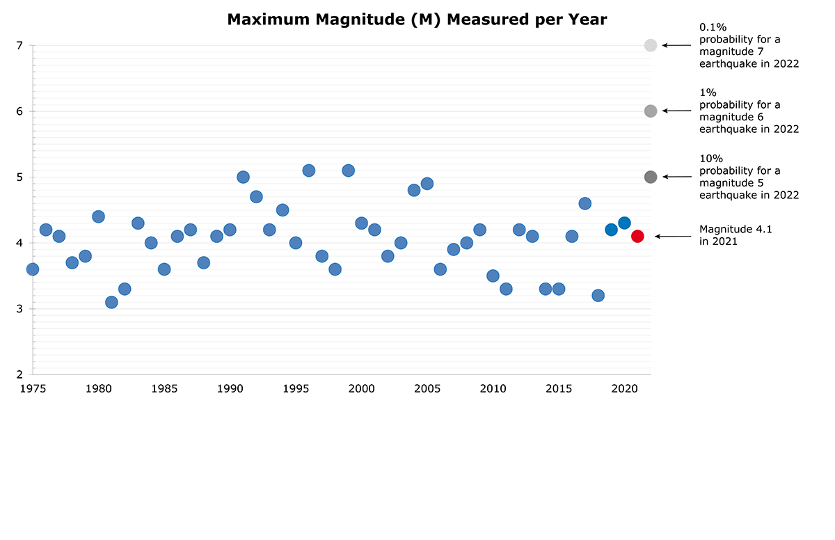
The Swiss Seismological Service (SED) records an average of between three and four earthquakes a day, or between 1,000 and 1,500 earthquakes a year, in Switzerland and its immediate neighbouring regions. Swiss citizens actually feel somewhere between 10 and 20 quakes a year, usually those with a magnitude of 2.5 or above. Earthquakes with a magnitude of at least 5 are expected to occur every 8 to 15 years. Larger earthquakes, with a magnitude of 6 or more, occur statistically only every 50 to 150 years in Switzerland and its neighbouring regions.
Learn more

The estimate of the regional distribution of Switzerland’s seismic hazard has not changed substantially in the last ten years: Valais remains the region with the highest hazard, followed by Basel, Grisons, the St. Gallen Rhine Valley, Central Switzerland, and the rest of Switzerland.
Learn more
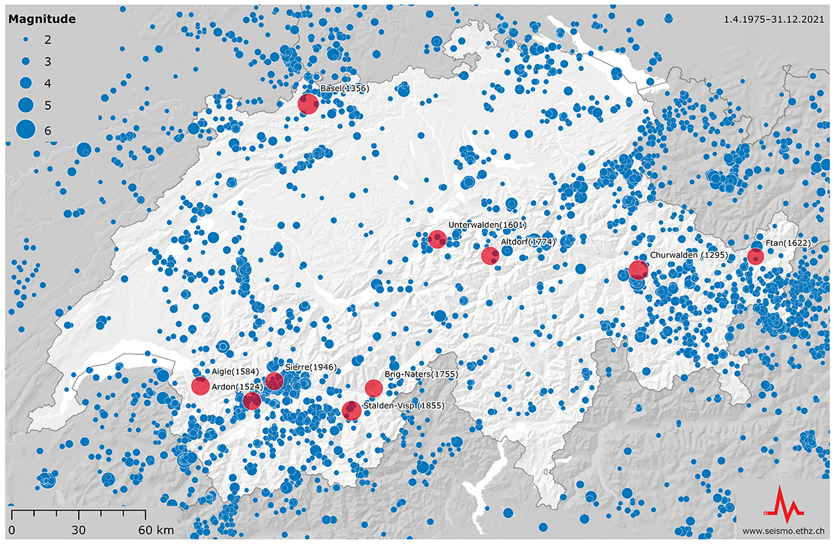
Map of the instrumental recorded earthquakes between 1975 and 2023 with a minimum magnitude of 2.

Every year, Switzerland experiences around 10 to 15 perceptible earthquakes. Quakes with a magnitude of at least 5 are expected to occur every 8 to 15 years. Larger seisms, with a magnitude of 6 or more, occur statistically only every 50 to 150 years in Switzerland and its neighbouring regions.
A magnitude 6.6 earthquake, the strongest ever to occur north of the Alps, shook Basel in 1356. The cantons of Grisons and Valais both experienced magnitude 6.2 earthquakes, in 1295 and 1855 respectively. These were the joint second strongest historically confirmed earthquakes in Switzerland.
The strongest Swiss earthquake recorded since the establishment of the comprehensive measuring system set up by the Swiss Seismological Service (SED) in the mid-1970s occurred near Vaz in Grisons in 1991, registering a magnitude of 5.0. The strongest earthquake to occur in a neighbouring country occurred in Annecy (France) in 1996 and had a magnitude of 5.2.
Learn more
The ten strongest earthquakes in Switzerland
Even though the terms earthquake hazard and risk are often used as synonyms, they have different meanings.
Earthquake hazard indicates how often and how intensely the earth could shake at a given location in the future. It is based on tectonic, geological and historical earthquake knowledge, and wave propagation models.

Earthquake risk describes the possible effects of earthquakes on people and buildings and the associated financial losses. The earthquake risk model combines detailed information on the earthquake hazard, the influence of the local subsoil, the vulnerability of buildings, and the affected people and assets.

Estimation of an earthquake hazard level indicates where and how often within a given time period certain instances of horizontal acceleration are likely to occur. It is based on tectonic, geological and historical earthquake knowledge, and wave propagation models.
Compared to the rest of Europe, Switzerland faces a moderate earthquake hazard. However, earthquake activity is not distributed evenly nationwide: the canton of Valais is prone to the highest hazard level, followed by Basel, Grisons, the St. Gallen Rhine Valley, Central Switzer-land and then the rest of the country. There are no regions without any earthquake hazard.
Experts and authorities base their decisions on earthquake mitigation and risk management measures on the SED's seismic hazard model, which also underpins the Swiss Seismic Building Code.
Earthquake-resistant residential or office buildings in Switzerland are designed to withstand shaking that is expected to occur where the building is situated once every 500 years on average. The lifetime of a building is approximately fifty years. Within this period, the probability of a residential or office building experiencing the design shaking is ten percent (10 % within 50 years).
Learn more
The earthquake hazard map illustrates the horizontal acceleration at 5 hertz; the probability of a building constructed on rocky subsoil experiencing this is 10 % within fifty years.

Although earthquakes occur less frequently than other natural hazards in Switzerland, they can cause serious damage. According to the "National risk analysis report" (Disasters and Emergencies in Switzerland 2020" of the Federal Office for Civil Protection (FOCP), earthquakes are one of the greatest risks in Switzerland, along with pandemics and power shortages.
Earthquake risk describes the possible effects of earthquakes on buildings and the associated financial and human losses. It is composed of four factors:
- Earthquake hazard
- Local subsoil
- Vulnerability of buildings
- Affected people and assets
Over a period of 100 years, earthquakes can be expected to cause economic damage of CHF 11 to 44 billion to buildings and their contents alone. In total, up to 1,600 people would lose their lives and an estimated 40,000 to 175,000 would become homeless on a short-term or long-term basis. On top of this, there is damage to infrastructure and losses due to other effects of earthquakes such as landslides, fires or business interruptions. However, these are not yet included in the model. The risk is not evenly distributed over time, but is dominated by rare, catastrophic earthquakes that usually happen without warning.
The greatest earthquake risk is in the cities of Basel, Geneva, Zurich, Lucerne and Bern, in that order. Although the earthquake hazard in these regions differs, all five cities have, by virtue of their size, a large number of people and assets that would be affected by an earthquake. In addition, these cities have many buildings, some particularly vulnerable and often located on soft ground that amplifies seismic waves.
Use our interactive tool to determine by approximation your personal earthquake risk based on four factors and find out how to reduce it.
Learn more

The earthquake risk map is based on an index that combines the expected number of fatalities with the estimated financial losses due to building damage. The values indicated always refer to an area of 2 x 2 kilometres. The earthquake risk is highest in the areas coloured dark red. The light-blue areas have a lower risk because there are relatively few people and assets in these locations. Even so, the damage to individual buildings in these regions could be devastating. An earthquake risk exists, therefore, throughout Switzerland.
The location of an earthquake – the geographic longitude, latitude and depth of the seismic focus – as well as the exact time of its occurrence can be modelled from the data recorded at seismic monitoring stations using what are known as inversion methods. These methods rely on the fact that pinpointing the location and time is closely linked to the propagation velocities of seismic waves – the two are interrelated. How accurately the location and time of an earthquake can be determined is therefore heavily dependent on how well the propagation velocity of the seismic waves in the subsoil is known. The geometric distribution of monitoring stations is also key to the measurement quality.
For earthquakes in Switzerland, where we have a dense network of high-quality monitoring stations, the parameter that is least easy to determine is usually the earthquake depth. This is particularly true of relatively shallow quakes, occurring in the five kilometres immediately beneath the Earth's surface. This is because the propagation velocity of seismic waves can vary substantially here and the distribution of stations around the earthquake is often not conducive to accurately determining the depth.
The depth of an earthquake is always given relative to the geographic zero-height point of the coordinate system used, with positive values below that point. Here, we use the international standard WGS 84 or the Swiss national coordinate system LV95. The geographic zero-height point in Switzerland is the sea level of the Mediterranean at Marseille (adjusted based on the sea level at the mouths of the Rhine, Inn/Danube, Ticino/Po and Rhone). For more information, see: https://www.swisstopo.admin.ch/en/knowledge-facts/surveying-geodesy/faq.html.
As the Earth's surface in Switzerland is between 193 metres (level of Lake Maggiore) and 4,634 metres above sea level, earthquakes can also occur above sea level, meaning that they have negative depth values. In most cases, however, negative depths mean that the quake occurred relatively close to the surface, usually in the top two to three kilometres. Moreover, negative depths often indicate a relatively high degree of inaccuracy of the calculated value (within approximately one to three kilometres). For example, an earthquake with a depth of '-1.4 km', such as the one above Aigle, near Montreux, on 9 July 2021, is likely to have occurred somewhere between one and three kilometres below the Earth's surface at that point.
Earthquake Terms
The hypocenter is the point of seismic focus in the ground (i.e. the point from which seismic waves originate) and is generally designated by its depth, longitude and latitude.
The epicenter is the vertical projection of a hypocenter onto the Earth’s surface (i.e. the point on the Earth’s surface directly above the hypocentre) and is generally designated by its longitude and latitude.

Magnitude is a measure of the energy released during an earthquake, i.e. its strength. In principle, the greater the magnitude of an earthquake, the stronger the ground motion it will cause. Unlike an earthquake's intensity, which will vary with the distance from the earthquake, its magnitude is independent of its location (see the question "What is intensity?“).
Magnitude is a logarithmic value, and an increase of one magnitude signifies a roughly 30-fold increase in energy. So a magnitude 6 earthquake is thirty times stronger than a magnitude 5 earthquake and 900 (30 x 30) times stronger than a magnitude 4 earthquake. In other words, an 0.2 increase in magnitude signifies an earthquake of double the energy. Consequently, a magnitude 3.4 earthquake is roughly twice as powerful as a magnitude 3.2 earthquake.
The magnitude of an earthquake is usually determined by records called seismograms generated by seismic measuring devices called seismometers (see the questions "What is a seismogram?" and "What is a seismometer and how does it work?"). The first magnitude scale was developed by physicist and seismologist Charles Richter in 1935. Even today, the size of an earthquake in Switzerland is usually specified using the Richter scale. However, over time it became apparent that the Richter scale is only suitable for earthquakes of certain magnitudes occurring within specified distance ranges, so other magnitude scales have been developed (see the question "What types of magnitude are there?").
Earthquakes can be felt above a magnitude of approximately 2.5. Quakes with a magnitude of roughly 4.5 to 5.5 can be expected to cause minor damage to individual buildings, though in rare instances they may also cause serious damage. The impact of an earthquake depends very much on a building's distance from the hypo- and epicentre, how it was constructed and the properties of the local subsoil.
The most powerful earthquake ever measured, with a magnitude of 9.5, occurred in Chile in 1960. At the other end of the scale, some earthquakes have magnitudes of less than zero (see the question "What does minus magnitude mean?").
Comparing earthquakes' magnitudes

Potential consequences of earthquakes of different intensities and magnitudes

The first magnitude scale was developed in 1935 by the physicist and seismologist Charles Richter, and even today earthquakes are commonly classified in units on the Richter scale (local magnitude). However, over time it became apparent that the Richter scale was only suitable for earthquakes of certain magnitudes and occurring within specific distances because it does not accurately reflect the quantity of energy released by very large or extremely distant earthquakes. For this reason, other magnitude scales were developed.
Local magnitude ML (the Richter scale)
| Use | Local magnitude, abbreviated ML (though the Swiss Seismological Service (SED) often uses the acronym MLh), is determined for earthquakes that occur relatively close to recording stations, normally for distances of up to a few hundred kilometres between the station and the earthquake. |
| Determining parameters | The local magnitude of an earthquake depends on its maximum amplitude as recorded by a Wood-Anderson seismometer (see the question "What is amplitude?"). Since this type of seismometer is barely still in use today, the vibrations measured by modern equipment are converted into artificial Wood-Anderson seismograms. |
| Advantages | Local magnitudes are very quick and easy to calculate. Furthermore, Wood-Anderson seismometers are sensitive within a frequency range very similar to smallish buildings (see the question "What is frequency?"). This makes the estimated local magnitude a good basis for predicting potential damage to properties. |
| Disadvantages | If an earthquake has a magnitude higher than around 6, the ML 'tops out', i.e. does not rise significantly even if the earthquake was larger. What is more, the ML is less meaningful for earthquakes with a magnitude of less than around 2 or which occurred further than about 600 km from the measuring station. |
Local magnitude MLhc
| Use | In 2020, the SED revised the previously used local magnitude and changed it from "MLh" to "MLhc". The "c" stands for "corrected". Since the last time the local magnitude scale was changed, the seismic network in Switzerland has very significantly densified. The revised local magnitude MLhc calibrated for Switzerland allows the SED to take advantage of this change. For smaller earthquakes, MLhc enables to accurately estimate magnitudes since it is correctly calibrated for seismic stations very close to the earthquake (within 15 to 20 km). In addition, the SED can use all seismic stations across Switzerland to determine MLhc, including those in urban areas, since it includes site amplification factors. |
| Determining parameters | The local magnitude of an earthquake is determined by taking the mean value of local magnitudes as determined at each seismic station. The local magnitude at each station depends on the maximum amplitude as recorded by a Wood-Anderson seismometer (see the question "What is amplitude?"); the distance of this station from the earthquake, and a site specific amplification factor. The original Wood Anderson seismometer has been replaced decades ago by modern broadband seismometers that have much larger amplitude and frequency ranges. In order to be consistent with the original magnitude scale, the vibrations measured by modern equipment are first converted into artificial Wood-Anderson seismograms. |
| Advantages | The calculation of MLhc is based on a larger data set compared to the one previously used for the calculation of the local magnitude, using all earthquakes recorded back to 2000. Recordings from almost all stations can now be used, even from those located within less than 15-20 kilometres from the earthquake focus in the ground (hypocentre). The procedure for calculating MLhc takes into account physics-based site corrections that are routinely calculated and updated by the SED. |
| Disadvantages | As any local magnitude definition, MLhc exhibits saturation for moderate-to-large magnitude events. This becomes apparent for events greater than magnitude 6. |
Body wave magnitude mb
| Use | Body wave magnitude is normally used for earthquakes that occurred more than 2,000 km away from a measuring station. |
| Advantages and determining parameters | The mb for such distant earthquakes can be estimated relatively quickly because it is derived directly from the amplitudes of P waves, compression waves that are transmitted through the Earth and are the first signals to reach a seismic station (see the question "What are P, S, Love and Rayleigh waves?"). |
| Disadvantages | If an earthquake has a magnitude higher than around 6, the mb tops out, making it unable to distinguish between, say, magnitude 6 or 7.5 earthquakes. |
Surface wave magnitude MS
| Use | Surface wave magnitude (MS) is used to estimate the energy released by strong and/or distant earthquakes. |
| Determining parameters and disadvantages | The MS is calculated from surface wave data. The velocity of surface waves (S waves) is far lower than that of P waves, which pass through the Earth (see the question "What are P, S, Love and Rayleigh waves?"). The slow propagation of surface waves explains why, after an earthquake occurs, seismologists cannot estimate immediately whether it was strong or very strong. Moreover, earthquakes occurring very deep underground may generate few surface waves or even none at all. |
| Advantages | The MS only tops out in the event of very large earthquakes with a magnitude higher than around 8. Earthquakes that occur close to the surface (within the topmost 30 kilometres) generate stronger surface waves than deeper quakes of the same magnitude. If the MS value of an earthquake is higher than its mb value, this is an indication that the quake occurred near the surface and can be expected to cause greater damage, assuming its epicentre is close to a densely populated region. The MS:mb ratio is also used to distinguish earthquakes from (nuclear) explosions, which have a smaller source volume than an earthquake of similar magnitude. In addition, explosions generate fewer shear waves, which play a major role in forming surface waves. Accordingly, explosions tend to be associated with far lower MS values. This makes the mb:MS ratio a good criterion for distinguishing between shallow earthquakes and explosions: if the value is high, the event was probably caused by an explosion. |
Moment magnitude Mw
| Use |
Moment magnitude (Mw) is the most revealing type of magnitude because it is the only type of magnitude that does not saturate, regardless of how powerful the earthquake is. The classical determination of Mw was based on long-period (low-frequency) parts of the seismograms at stations not too close to the earthquake, which meant that the determination was only possible reliably for earthquakes with magnitude 4 and above. In the meantime, Mw can also be determined for smaller quakes and even for micro-earthquakes with magnitudes in the minus range if the number and quality of the seismic stations are good enough (see the question "What does a negative magnitude mean?"). |
| Determining parameters |
The moment magnitude Mw (‘w’ stands for ‘work’) is the only type of magnitude which has a physical meaning. Mw was derived from the seismic moment M0 based on theoretical studies. M0 is the product of the size of the fault multiplied by the average displacement at the location of the fault multiplied by the shear strength of the rock. There are several ways to determine Mw. Often synthetic seismograms are matched to actual observations. This entails varying the size of the fault, the mean vertical displacement und the fault's orientation until the synthetic seismograms sufficiently match their naturally recorded equivalents. In many cases, the amplitude spectrum of the earthquake signal is used, whose long-period plateau value is a measure of the seismic moment M0. In order to correct the influence of the station’s local soil conditions, the geometry of the earthquake focus and the noise, it is necessary to assess M0 at a sufficient number of stations, from which an average value is then determined. Especially for the determination of Mw for micro-earthquakes, the seismic stations have to record the signals with sufficient high sampling to determine the plateau value of the spectrum. |
| Advantages |
Mw directly indicates the energy released during an earthquake and does not saturate even during the largest earthquakes. Furthermore, Mw is globally comparable. |
| Disadvantages |
Estimating Mw is more time-consuming than calculating other types of magnitude. When larger earthquakes occur, it can take a several hours to produce an initial estimate. |
M
If you find magnitude designated simply as 'M' in one of our lists, this indicates that the seismic observatory that estimated it did not specify which type it used. This is often the case for observations made by the US Geological Survey. In such instances it is assumed that a type of magnitude that does not 'top out' was used. For strong earthquakes, this often means Mw.
When the logarithmic magnitude scale was developed a few centuries ago (see the question "What is magnitude?"), its zero value was set at the earthquake threshold perceptible by seismographs at the time. However, measurement technology has improved in leaps and bounds tremendously since then, so today's seismographs can register earthquakes far below the old zero value.
The zero point on the magnitude scale has no special physical significance. It just means that a magnitude 0.0 earthquake is around twice as intense as a -0.2-magnitude earthquake and approximately half as intense as a magnitude 0.2 earthquake.
Very small earthquakes are called microquakes and fall way below the human perception threshold (see the questions "What is microseismicity?" and "When do earthquakes become perceptible?".
Earthquakes with magnitudes of -5.0 have been detected in deep boreholes of geothermal power plants.
The intensity describes the strength of an earthquake based on the extent of the destruction (buildings, landscape) and the subjective perception of an observer. The intensity of an earthquake is location-specific and is defined by the magnitude, the distance to the hypocenter and the geology of the subsurface.
The European Macroseismic Scale 1998 (EMS-98) uses numbers between I (not felt) and XII (complete destruction) for the individual classification of earthquakes.
Nowadays, determining the intensity can be done instrumentally as well by looking at the peak ground velocities and accelerations at a station, among other considerations. In this way an overview of the distribution of ground movements in an area can be attained much quicker than by questioning the affected population and by damage evaluation, which are needed in the classical approach to creating an intensity map. The values can be displayed as dots on a map and / or they can be connected to form contours (ShakeMaps).
Learn more
Potential consequences of earthquakes of different intensities and magnitudes
The key factor in determining peak ground acceleration (PGA) and peak ground velocity (PGV) is the horizontal ground movement caused by an earthquake and recorded at the Swiss Seismological Service’s measuring stations. Both peak ground acceleration and peak ground velocity can be depicted on a ShakeMap (see “What are ShakeMaps?”).
Peak ground acceleration and peak ground velocity values are crucial for producing seismic hazard maps used to draw up construction standards for earthquake-resistant structures.
Both peak ground acceleration and peak ground velocity depend on several factors: the length and direction of the fault (and thus the magnitude of the earthquake: see “What is a fault and what is a rupture surface?”), the distance between the measuring station and the epicentre, and the geology of the subsoil in the area concerned. Even small variations in the subsoil beneath measuring stations can affect ground acceleration significantly. As a result, the ground acceleration values recorded for a single quake can vary considerably from one small area to the next. As a general rule, the greatest velocity and acceleration values will be recorded near to the epicentre and in the direction of fault propagation. The higher the acceleration value and/or velocity, the greater the likelihood of damage. In the case of small quakes (i.e. of a magnitude of less than 3), what the local population feels is the acceleration (Wu et al., 2003). By contrast, damage to buildings generally correlates to the ground velocity.
Peak ground acceleration is measured in m/s2 or as a fraction or multiple of the Earth’s gravitational acceleration (g = 9.81 m/s2). Peak ground velocity is measured in m/s.
The Swiss Seismological Service has been recording peak ground acceleration and peak ground velocity during earthquakes since 1992. The highest peak ground acceleration recorded to date was that of 2.13 m/s2 during a magnitude 3.4 earthquake in Linthal in the canton of Glarus that occurred on 17 March 2001. The highest ever peak ground velocity of 3.6 cm/s was also recorded during the Linthal quake. The measuring station at which these values were recorded was located approximately 730 m from the epicentre.
Learn more
ShakeMap of the magnitude 3.4 earthquake that occurred in Linthal on 17 March 2001

Earthquake Monitoring and Analysis
Earthquakes cannot currently be systematically predicted. However, phenomena that could herald earthquakes are being monitored, including earthquake lights, earthquake clouds, elevated concentrations of radon, seismic quiet, electromagnetic signals, conspicuous animal behaviour and foreshocks, which sometimes precede main quakes (though only after a main quake does it become clear that they were actually foreshocks). But so far no patterns have been observed that could enable us to predict earthquakes reliably.
Nonetheless, three factors are known to have close links with earthquake prediction:
- Earthquake early warning: The Swiss Seismological Service (SED) is currently testing an earthquake early warning system. Monitoring stations close to an earthquake immediately register the seismic waves it generates and trigger a warning for areas further away. Such warnings can be issued because the measurements are transmitted at the speed of light, i.e. faster than the speed at which seismic waves are propagated (around 3.5 km per second). However, since earthquake early warnings can only be given at a certain distance from the epicentre and are only useful for more powerful earthquakes, their practical use for Switzerland remains to be determined.
![]() Play animation © SRF Einstein
Play animation © SRF Einstein

- Seismic hazard: The seismic hazard shows where within a certain timeframe and how frequently certain incidents of horizontal acceleration are likely to occur.
- Earthquake models:Sophisticated models allow increasingly accurate statements on how probable an earthquake of a specific magnitude is within a specific region at a specific time:
- Large earthquakes are often preceded by smaller ones
Smaller earthquakes significantly increase the probability of a subsequent severe earthquake occurring. However, in absolute terms, the probability is still very low. - Strong earthquakes are only rarely followed by even stronger ones
The probability of an earthquake with a magnitude of 5.0 being followed within the next seven days by an earthquake of equal or greater magnitude is around 10 percent. This means that in 9 out of 10 cases, no earthquake with a magnitude of 5.0 or above will occur over the following week. - Aftershocks are the norm
Very strong ground movements triggered by an aftershock are around 1,000 times more likely than the statistical mean to occur on the first day after an earthquake with a magnitude of 5.0.
- Large earthquakes are often preceded by smaller ones
Learn more
Earthquakes used to be measured using seismographs, but today's modern measuring devices are called seismometers (see the question "What's a seismometer and how does it work?“).
More than 200 earthquake stations installed and operated by the SED constantly monitor earthquake activity in Switzerland and its neighbouring regions. The measuring instruments at these stations can be divided into three different types:
- Broadband seismometers: these highly sensitive instruments register even the slightest ground tremors caused by weak local, moderate regional and moderate to strong earthquakes around the world. They are preferably installed in remote locations on solid rock.
- Accelerometers: these instruments are suitable for measuring moderate and strong local tremors. They are mainly installed in urban areas and particularly high-risk regions.
- Short-period seismometers: these instruments register weak local tremors.
Learn more
Map of all real-time stations monitored by the SED in Switzerland
Rapid Impact Assessments inform the public and emergency services about the expected impacts in the event of damaging earthquakes or quakes that can be felt over a wide area. The SED will publish Rapid Impact Assessments after each earthquake with a magnitude of 3 or greater. Isolated damage is possible near the epicentre with quakes of around magnitude 4 or above.
The values given in the RIAs regarding the anticipated consequences of an earthquake are automatically generated based on assumptions derived from the earthquake risk model of Switzerland. The actual values may vary considerably under certain circumstances; therefore, all information is provided without warranty and is subject to change.
Earthquake scenarios show the possible effects of earthquakes. They are an important element of earthquake preparedness and help the population, authorities and the economy to be better prepared for earthquakes and their possible impacts.
Such scenarios can be used to illustrate the impacts to be expected today from historical damaging earthquakes in Switzerland or the impacts of future earthquakes. However, severe earthquakes could in theory occur anywhere. The SED therefore provides a scenario for a damaging magnitude-6 earthquake for every cantonal capital and one other locality in each canton. Such an earthquake happens on average every 50 to 150 years somewhere in Switzerland or its neighbouring regions.
Learn more
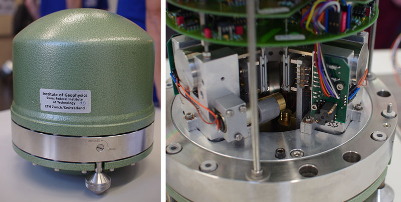
A seismometer is an extremely sensitive electromechanical device used to measure ground movement in a particular area in the order of nanometres (millionths of a millimetre). The movement recorded on a time axis called a seismogram.
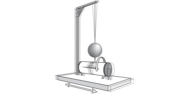
Earlier mechanical instruments were called seismographs. In 1922, Alfred de Quervain – a geophysicist and former director of the Swiss Seismological Service – explained the conventional principle of recording earthquake measurements as “[…] suspending a heavy body freely in such a fashion that it remains immobile as an inert mass during ground tremors”. Seismographs incorporated a stylus attached to the mass (and therefore also immobile) which traced ground movements onto, for example, a cylindrical sheet of paper, which rotated as the tremors occurred. Depicting all three axes (north-south, east-west and the vertical) required two horizontal and one vertical pendulum systems.
Nowadays, a seismometer is used to measure the current required to keep a magnetic mass as still as possible during ground tremors: this is known as a force-feedback system, and the force can be calculated from ground movements. The triaxial suspension mechanism means that all three axes can be measured using a single pendulum device (in the past, three separate pendulum masses were inclined against the vertical in the form of the edges of a cube standing on one of its corners).
A seismogram is the electronic recording made by a seismometer of the ground movements associated with earthquakes. The resulting diagram is wave-shaped with varying amplitudes and wavelengths since the movement at a measuring station during an earthquake is non-linear (see question "What are the period, wavelength and amplitude?"). The energy released by an earthquake (magnitude) as well as the location of its hypocenter can be estimated by evaluating a large number of such diagrams.
Learn More
Realtime waveforms last 5 minutes
Realtime waveforms last 20 minutes
Realtime waveforms last 2 hours
Realtime waveforms last 24 hours
Seismograms of the earthquake on 30 January 2014 near Gelterkinden in the canton of Basel-Landschaft

The period, wavelength and amplitude of seismic waves are measured using seismometers and depicted on seismograms (see “What is a seismometer?” and “What is a seismogram?”).
A period is the duration of a single oscillation and is measured in seconds.
A wavelength is the spatial equivalent to a period and is the length of a single oscillation. In the case of seismic waves, the wavelength value is typically in the region of between several dozen metres and several kilometres.
The amplitude is the force or deflection of a single oscillation. Modern seismometers are able to record amplitudes of less than one nanometre (one millionth of a millimetre).
As a rule, it takes measurement data from several seismic stations to ascertain exactly when and where an earthquake occurred. For this reason, more than 100 such stations spread across the country, set up and run by the Swiss Seismological Service (SED), monitor earthquake activity around the clock in Switzerland and its neighbours. The data they record are gathered, almost in real time, by the SED's data centre in Zurich and automatically analysed. As soon as at least six stations register signals indicating potential seismic waves, the system tries to pinpoint where the earthquake originated (see the question "What's a hypocentre and what's an epicentre?") and when it occurred, based on the times at which the signals were received.
The key here is that stations located close to an earthquake's place of origin register the seismic waves earlier than more distant stations. Furthermore, earthquakes cause different kinds of waves, which spread through the ground and across the surface of the planet at different spreads (see the question "What are P, S, Love and Rayleigh waves?"). Based on these timing differences and a velocity model specially devised for Switzerland (seismic waves pass faster through dense Alpine rock and deep layers of the Swiss plateau than through the plateau's sedimentary basin), an earthquake's time of occurrence and place of origin can be very precisely determined. Moreover, the SED’s 24-hour on-call service manually analyses and recalculates the location of every earthquake, taking account of other properties of the various types of earthquake waves as well.
The colour reflects the velocity of the P wave
For every earthquake with a magnitude of 2.5 or greater, the Swiss Seismological Service (SED) publishes both a map of ground shaking and a ShakeMap. These provide an overview of the ground motion and anticipated impact of an earthquake. ShakeMaps supply considerably more information than standard earthquake maps, which typically show only the epicentre and magnitude. ShakeMaps' additional details are useful to those affected by ground shaking as well as to rescue workers, who can use them as a basis for further action.
In addition to ShakeMaps depicting earthquake intensity, there are also some that show peak ground acceleration (PGA) and peak ground velocity (PGV) (see "What are peak ground velocity and peak ground acceleration?"). These data are particularly important for civil engineers.
Learn more
ShakeMap of an earthqake near Elm on November 10, 2020 with magnitude 3.9. The hypocentre was located at a depth of about 1.7 kilometers.

Coordinated Universal Time (UTC) is the internationally applicable world time standard. In seismology, it is used to make international earthquake data easier to compare and utilise by eliminating the complications associated with different time zones and hemispheres.
Coordinated Universal Time was introduced in 1972 and corresponds to Greenwich Mean Time, i.e. the time along the prime meridian running through the observatory located in the London borough of Greenwich. Time zones west of the prime meridian are behind UTC, while those to the east are ahead of it.
UTC follows the highly precise second-based International Atomic Time (TAI). Since the Earth’s rotation can fluctuate and a day can therefore last longer than 24 x 3,600 seconds, from time to time a leap second is added.
Standard time in Switzerland is Central European Time (CET), which is one hour ahead of UTC (UTC +1). Central European Summer Time (CEST) is two hours ahead of UTC (UTC +2).
UTC time zones

The work done by employees of the Swiss Seismological Service (SED) work can be subdivided into four main domains or sections:
- Earthquake Monitoring
- Earthquake Analysis
- Earthquake Hazard and Risk Assessment
- Support and Special Projects.
The main focus of seismologists' work is on continuously monitoring seismic activity. This includes analysing data recorded by seismic measuring systems (see the question "How are earthquakes measured?") and immediately alerting the authorities, the media and the general public in the event of an earthquake.
The SED's seismologists also endeavour to ascertain the danger posed by earthquakes in various parts of Switzerland and interpret earthquake data to acquire knowledge about the subsurface or the links between plate boundaries, geology and earthquakes. The main focus of these efforts is on answering the following questions: Why do earthquakes occur in certain areas? Which faults are active? Where and when will earthquakes happen in the future, and how strong will they be?
At the same time, the SED's seismologists support national and international projects. For example, they monitored and analysed seismic activity during the geothermal energy projects in Basel and St. Gallen and set up a temporary seismic network in Bhutan.
In addition to this, many seismologists are involved in teaching by way of giving lectures and mentoring students and PhD candidates at ETH Zurich.
Learn more
A video in which the SED's seismologists give an insight into their daily work
The SED's employees
Earthquake Impacts
Near the epicenter, earthquakes with a magnitude of just 2.5 or greater can be felt. Only rarely do we receive earthquake announcements for events with a magnitude of slightly less than 2. Earthquakes are felt widespread at magnitudes of 3 or greater. Earthquakes with magnitudes of between 4 and 5 can be noticed within a radius of 100 to 200 kilometers. At magnitudes of 5 or greater, it may be several hundred kilometers under certain circumstances.
Learn more
Potential consequences of earthquakes of different intensities and magnitudes
This question cannot be answered in a general way. Using various scenarios that illustrate earthquakes with a magnitude of 6 in all cantonal capitals and one other location, as well as historical examples, the expected impacts in Switzerland can be assessed in more detail.
Buildings constructed using the methods typically applied in Switzerland can be damaged by earthquakes with intensities of VI or VII and above. This corresponds to a magnitude of approximately 5 (see the questions "What does the intensity of an earthquake on the European Macroseismic Scale (EMS-98) tell us?" and "What is magnitude?"). Destructive damage can be expected at an intensity of IX or greater or at a magnitude of around 6 or above. Smaller cracks or damage caused by falling objects can even occur at lower intensities.
Learn more
Potential impact of earthquakes of varying intensity and magnitude
Earthquakes cannot be predicted. However, their potential effects and damage can be minimised by taking some simple measures at home and when on holiday.
- Earthquake-resistant building design offers the best protection against the consequences of an earthquake.
- Consider taking out earthquake insurance to reduce your personal (financial) risk.
- Inside buildings, make sure that objects that could fall down or topple over due to the shaking, and thereby cause injuries, are secured.
- Make sure you are prepared for an earthquake (or other emergency situation): be clear in your mind about what you should do in such a situation at any given location (at home, at work, while travelling, when on holiday).
Learn more
What to do before, during, and after a strong earthquake
Only to a limited extent. Although corresponding standards have been in force since 1989, only a small number of cantons insist upon their implementation. The following cantons have explicitly anchored adherence to the applicable standards of the Swiss Society of Engineers and Architects (SIA) in their statutory regulations, or impose earthquake-specific conditions within the context of planning permission procedures:
- Aargau
- Basel City
- Fribourg
- Jura
- Lucerne
- Nidwalden
- Valais
As a rule, buildings constructed before 1989 did not take earthquakes into account.
Learn more
Earthquake-Resistant Construction
Federal Office for the Environment (FOEN)
No, as a rule, earthquake damage is insured only to a small extent in Switzerland. In the event of a major earthquake, most house and apartment owners would not be reimbursed for the cost of any possible damage, or would be reimbursed only partially. The specific rules vary from canton to canton. Parliament is currently discussing whether to extend the obligatory fire and natural hazards insurance to cover earthquake damage.
Learn more
Tsunamis do not occur only at sea. On rare occasions, large flash-flood waves are produced in (Swiss) lakes.
Ocean tsunamis occur when an earthquake suddenly raises or lowers the seabed, possibly accompanied by submarine landslides (if the ocean floor merely shifts horizontally, there is barely any impact on the volume of water above it).
The main causes of lake tsunamis are rock avalanches and sediment slides, which may occur above or below water, but are not necessarily triggered by earthquakes.
Learn more
FAQ
