News Archive 2019
2019-12-18
Merry Christmas and a Happy New Year
One memorable event of the past year was undoubtedly the earthquake swarm that occurred north of Sion in Valais in November. So that was the inspiration for this year's Christmas card. The baubles on the Christmas tree represent the numerous quakes of the swarm, and the mountain range behind it represents the cumulative number of tremors. Click on the impage for a detailed view.
The Sion earthquake swarm took place in a region historically known for its seismic activity and where numerous small and occasionally larger quakes can also be expected in the future. There is no way of predicting exactly how seismic activity will develop there, but analysing the extensive data provided by this earthquake swarm is helping us gain a clearer understanding of earthquake activity in the area.
We wish you a very Merry Christmas and a happy and instructive New Year!
2019-11-30
[Available in DE / FR] Erdbeben bei Verbier (VS)
Am Samstag, den 30. November 2019, ereignete sich um 03:14 Uhr (Ortszeit) ein Erdbeben der Magnitude 3.0 in einer Tiefe von ca. 2 km östlich von Verbier (VS).
Das Erdbeben wurde weiträumig verspürt, insbesondere im Rhonetal, wo die weichen Sedimente die Erdbebenwellen verstärkten. Beim SED gingen in der Stunde nach dem Beben etwa 200 Verspürtmeldungen ein. Bei einem Erdbeben dieser Stärke sind keine Schäden zu erwarten.
Das Wallis ist der erdbebenreichste Kanton der Schweiz. Die Region südlich des Rhonetals ist dabei im Allgemeinen weniger aktiv als die Region nördlich der Rhone, wo sich im November ein Erdbebenschwarm mit über 300 Erdbeben ereignete, wovon über ein Dutzend verspürt wurden. Das aktuelle Beben hat keinen kausalen Zusammenhang mit diesem Erdbebenschwarm.
![[Available in DE / FR] Erdbeben bei Verbier (VS) [Available in DE / FR] Erdbeben bei Verbier (VS)](/export/sites/sedsite/home/.galleries/img_news_2019/verbier.png_2063069299.png)
2019-11-15
[Available in DE/FR] Erdbebenschwarm nördlich von Sion (VS): Entwicklung vergangene Woche
Der Erdbebenschwarm nördlich von Sion (VS) ist nach wie vor aktiv. In den vergangenen sieben Tagen haben sich über 100 weitere Beben ereignet, womit die Gesamtzahl der aufgezeichneten Ereignisse aktuell bei mehr als 300 liegt. Für die Bevölkerung waren in diesem Zeitraum zwei weitere Beben spürbar. Sie ereigneten sich am 11. und 12. November 2019 und wiesen eine Magnitude von 2.7 auf. Mit aktuell 16 verspürten Beben weist der Erdbebenschwarm eine ungewöhnliche Häufung an Erschütterungen auf, die genug stark sind, um von der Bevölkerung wahrgenommen zu werden. Wie sich der Erdbebenschwarm weiterentwickelt, bleibt weiterhin unklar. Es kann zudem nach wie vor nicht ausgeschlossen werden, dass sich ein stärkeres Beben ereignet.
Der letzte Erdbebenschwarm in der jüngeren Vergangenheit, der eine annähernd gleich hohe Anzahl an verspürten Beben auslöste, wurde 2003 im Sertigtal (GR) beobachtet. Innerhalb von 26 Tagen ereigneten sich sechs Beben mit einer Magnitude von 2.5 oder mehr, wobei die zwei grössten eine Magnitude von 3.9 aufwiesen. 1992 ereignete sich zudem in Vaduz (FL) ein deutlich spürbares Beben mit einer Magnitude von 4.7, dem in den kommenden sieben Tagen sechs Beben mit Magnituden von 2.5 oder mehr folgten. Weiter zurück in der Vergangenheit und deutlich stärker und aktiver war der Erdbebenschwarm, der zwischen Februar und Mai 1964 im Raum Sarnen zu über 50 verspürten Beben geführt hat. Das grösste ereignete sich am 3. März 1964 und richtete mit einer Magnitude von 5.3 beträchtliche Gebäudeschäden an. Der Blick in die Vergangenheit belegt, dass 16 verspürte Beben innerhalb von zehn Tagen dennoch vergleichsweise selten auftreten.
Im Durschnitt hat sich seit Beginn des Schwarms alle 43 Minuten ein Beben ereignet. Die Aktivität ist dabei nicht gleichmässig verteilt, es wechseln sich Phasen gesteigerter Aktivität mit eher ruhigen Perioden. Dies ist auf der Grafik oberhalb deutlich zu erkennen. Sie zeigt, wie sich die Bebenaktivität über die Zeit entwickelt hat. Dabei scheint es, als ereignen sich vor allem nachts mehr kleine Beben. Das ist nicht der Fall, aber aufgrund des geringeren Umgebungslärms (z. B. Strassenverkehr) können nachts mehr kleine Beben aufgezeichnet werden. Die Abbildung umfasst einerseits die über 300 Beben (rot umrandet), die mittels der standardmässigen Auswertung der aufgezeichneten Daten eindeutig bestimmt werden konnten. Anderseits sind weitere, sehr kleine Ereignisse abgebildet. Diese konnten nachträglich durch einen systematischen Vergleich der Wellenformen ermittelt werden, jene der kleinen Beben weisen ähnliche Muster auf wie die der standardmässig aufgezeichneten. Die dazu angewendete Methode des «template-matching» wird derzeit am SED erforscht und weiterentwickelt. Sie ermöglicht, solche Sequenzen noch besser zu verstehen.
Als mögliche Ursache für solche Schwärme werden oft Änderungen der lokalen Spannungsverhältnisse im Gestein diskutiert, die beispielsweise durch Umlagerungen und Bewegungen von Fluiden (z. B. Wasser) hervorgerufen werden können. Ob solche Prozesse auch im gegenwärtigen Schwarm eine grössere Rolle spielen ist Gegenstand aktueller Forschungsarbeiten am SED.
![[Available in DE/FR] Erdbebenschwarm nördlich von Sion (VS): Entwicklung vergangene Woche [Available in DE/FR] Erdbebenschwarm nördlich von Sion (VS): Entwicklung vergangene Woche](/export/sites/sedsite/home/.galleries/img_news_2019/timeline_zoom_web_VS.png_2063069299.png)
2019-11-08
[Available in DE/FR] Erdbebenschwarm nördlich von Sion (VS): aktuelle Entwicklung und Ursachen
Über 200 Beben haben sich bis anhin seit der Nacht vom 4. auf den 5. November 2019 nördlich von Sion (VS) ereignet. Vierzehn dieser Beben wurden von der Bevölkerung verspürt. Die zwei bisher grössten Beben wiesen eine Magnitude von 3.3 auf. Obwohl sich am Abend des 7. Novembers zwei weitere, spürbare Beben ereignet haben, hat der Erdbebenschwarm etwas an Stärke verloren. Es ereignen sich im Vergleich zur ersten Phase weniger und weniger starke Beben. Die weitere Entwicklung ist nach wie vor ungewiss. In der Regel nimmt die Aktivität eines solchen Schwarms innert Tagen bis Wochen fortwährend ab. In seltenen Fällen kommt es jedoch zu einem stärkeren Beben. Die Wahrscheinlichkeit für ein Beben mit einer Magnitude von 4 oder mehr innerhalb der nächsten Woche beträgt für den Bebenschwarm im Wallis aktuell etwa zwei bis fünf Prozent.
Read more...Erdbebenschwarm in bekannter Störzone
Der Erdbebenschwarm liegt in einem seismisch sehr aktiven Gebiet, das nördlich von Sion zwischen dem Diablerets und dem Wildhorn verläuft. Auf der Abbildung ist deutlich zu sehen, dass sich die Bebenaktivität bereits in der Vergangenheit auf ein ähnliches Gebiet konzentrierte. Die grauen Kreise zeigen die Beben, welche seit 1984 instrumentell erfasst wurden. Der aktuelle Erdbebenschwarm, gekennzeichnet durch die roten Kreise, liegt in der Mitte dieser Aktivitätszone. Unweit davon liegen die Epizentren einiger grösseren historischen Beben (blaue Sterne). Der Erdbebenschwarm vom November 2019 ereignet sich demnach in einem Gebiet, dass historisch für seine seismische Aktivität bekannt ist und wo auch künftig mit zahlreichen kleinen und vereinzelt grösseren Beben zu rechnen ist. Wie genau sich die seismische Aktivität in diesem Gebiet entwickelt, lässt sich jedoch nicht vorhersagen.
Weshalb bebt es in diesem Gebiet?
Das Wallis ist, im Vergleich zu anderen Gebieten der Schweiz, durch eine erhöhte Verformung des Untergrunds (Deformation) gekennzeichnet. Diese äussert sich sowohl in Form einer vertikalen Hebung als auch in einer horizontalen Deformation und hängt mit den gebirgsbildenden Prozessen der Alpen zusammen. Aus geologischer Sicht stellt die Rhone-Simplon Verwerfung eine der wichtigsten Störzonen in der Region dar. Sie verläuft im Bereich von Sion entlang des Nordrandes des Rhonetals. Die Seismizität im Bereich der helvetischen Decken nördlich des Rhonetals steht daher wahrscheinlich in Zusammenhang mit den Deformationsprozessen entlang der Rhone-Simplon Verwerfung, aber eventuell auch mit den tiefer liegenden Hebungsprozessen im Bereich des Aar Massivs und des Aiguilles Rouge/Mont Blanc Massivs. Ein verbessertes Verständnis dieser tektonischen Prozesse und ihrer Auswirkungen auf die heutige Seismizität sind Gegenstand aktueller Forschungsarbeiten beim SED.
Welchen Einfluss haben die tektonischen Untergründe der helvetischen und penninischen Decken?
Die Rhone-Simplon Verwerfung verläuft entlang der Grenze zwischen der helvetischen und der penninischen Decken im Bereich von Sion. Beide tektonisch Einheiten weisen sehr unterschiedliche Bruchmechanismen auf, was auf unterschiedliche tektonische Spannungsregime hinweist. Die seismisch aktive Struktur nördlich des Rhonetals, die den aktuellen Schwarm beinhaltet, «wurzelt» nach derzeitigem Kenntnistand vermutlich im oberen kristallinen Grundgebirge, reicht aber bis in die darüberlegenden Sedimente der helvetischen Decken. Die vorläufigen Ergebnisse der seismischen Auswertungen zeigen, dass der Erdbebenschwarm im Übergangsbereich zwischen Grundgebirge und Sedimenten in ca. 4 bis 5 km Tiefe liegt.
Was hat es mit den einzelnen Bruchsystemen auf sich?
In der Karte sind die verschiedenen Bruchsysteme durch die dunkelroten bis orangen Linien gekennzeichnet. In den helvetischen Decken sind Bruchsysteme unterschiedlicher Orientierungen im Bereich des Sanetschpasses geologisch kartiert. Allerdings ist der Zusammenhang der Brüche an der Oberfläche mit den heutigen Erdbeben in der Tiefe unklar. Erste Ergebnisse in Bezug auf die Bruchorientierungen im aktuellen Schwarm zeigen teilweise Übereinstimmungen mit den Bruchsystemen an der Oberfläche (es scheinen vor allem die WNW/W und WSW streichende Brüche aktiv zu sein, siehe Kartenlegende). Der Zusammenhang zwischen geologisch kartierten Brüchen und heutigen Erdbeben ist ebenfalls Gegenstand aktueller Forschungsarbeiten beim SED. Dass die Bruchsysteme so deutlich zu erkennen sind, ist dem dichten seismischen Netzwerk in der Region zu verdanken sowie neusten Analysemethoden.
![[Available in DE/FR] Erdbebenschwarm nördlich von Sion (VS): aktuelle Entwicklung und Ursachen [Available in DE/FR] Erdbebenschwarm nördlich von Sion (VS): aktuelle Entwicklung und Ursachen](/export/sites/sedsite/home/.galleries/img_news_2019/Anzere_Map_Overview_fin.png_2063069299.png)
2019-11-06
[Available in DE/FR] Erdbebenschwarm nördlich von Sion (VS) aktuell ruhiger
Seit dem 4. November 2019 haben sich ungefähr 150 Erdbeben mit Magnituden zwischen 0.1 und 3.3 nördlich von Sion (VS) ereignet. Zwölf davon wurden von der Bevölkerung teilweise deutlich verspürt, wie die über 1’500 eingegangen Verspürtmeldungen belegen. Seit dem Morgen des 6. Novembers hat der Erdbebenschwarm deutlich an Intensität abgenommen. Das heisst, es sind weniger häufig und weniger starke Beben aufgetreten. Ob es sich dabei um eine zwischenzeitliche Beruhigung handelt oder ob der Erdbebenschwarm tatsächlich langsam ausklingt, lässt sich daraus jedoch nicht mit Sicherheit schliessen. Der SED beobachtet weiterhin die Entwicklung der Seismizität und steht in Kontakt mit den Behörden im Kanton Wallis und auf Bundesebene.
Read more...Das seismische Messnetz des SED ist in der betroffenen Region sehr dicht und ermöglicht bereits kleinste Beben zuverlässig aufzuzeichnen. Aus diesem Grund besteht in diesem Fall kein Bedarf, das Messnetz durch weitere, temporäre Nachbenenstationen zu verdichten. Die Seismologinnen und Seismologen des SED sind aktuell mit der manuellen Auswertung und wissenschaftlichen Aufarbeitung der bisher aufgetreten Erdbeben beschäftigt. Aufgrund der grossen Anzahl an Beben wird die detaillierte Analyse noch etwas Zeit beanspruchen und erst in einigen Tagen vorliegen. Informationen und Erläuterungen zu aktuellen Beben publiziert der SED weiterhin regelmässig an dieser Stelle.
Obwohl sich die seismische Aktivität in den letzten zwölf Stunden deutlich verringert hat, ist es nicht klar, wie sich die Erdbebenaktivität entwickeln wird. Es ist somit immer noch möglich - wenn auch zunehmend weniger wahrscheinlich – dass weitere, noch stärkere Beben auftreten werden.
![[Available in DE/FR] Erdbebenschwarm nördlich von Sion (VS) aktuell ruhiger [Available in DE/FR] Erdbebenschwarm nördlich von Sion (VS) aktuell ruhiger](/export/sites/sedsite/home/.galleries/img_news_2019/Sanetschpass_Magnitudes_D.png_2063069299.png)
2019-11-06
Ongoing earthquake swarm north of Sion (VS)
[updated 11/06/2019, 07:30]
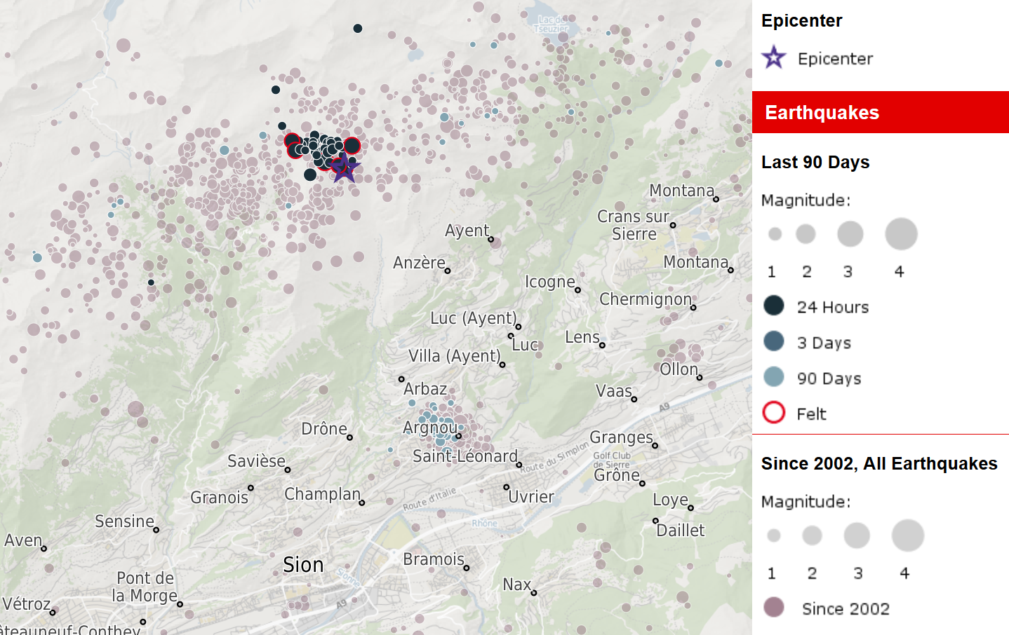
Starting in the night of 4 to 5 November, 2019, an exceptionally active earthquake swarm is ongoing near Savièse, north of Sion VS. Until the morning of 6 November, the seismic network of the Swiss Seismological Service at ETH Zurich (SED) has recorded more than 100 events. Twelve of these had magnitudes of 2.5 or larger and were widely felt by the population of the Sion region up to Sièrre. The four strongest quakes reached magnitudes between 3.0 and 3.3 and were sporadically felt even in the Bernese Oberland. Overall, the SED has collected several hundred felt reports on its website.
Such an accumulation of earthquakes is rather untypical for Switzerland. Earthquake swarms with many events within days or weeks happen regularly. However only rarely as many perceptible earthquakes occur within a small period of time. Still, predicting the future development of this sequence is not possible. Typically, the seismic activity decays after days, at most after weeks. However, there is a probability of 5 to 10 percent for significantly stronger earthquakes to occur within the next days.
Read more...The Valais is the most active earthquake region of Switzerland. The quakes of these days took place in one of the most prominent zones of activity which extends south of the Diablerets and Wildhorn massifs in parallel to the main valley. The last felt event in the area before the beginning of the current sequence was on January 14, 2018, however small, instrumentally detectable earthquakes are observed nearly on weekly basis. The last strongly damaging quake in Switzerland, a magnitude 5.8 which occurred on 25 January 1946, happened also near the Wildhorn and caused considerable damage in an expanded area.
2019-10-23
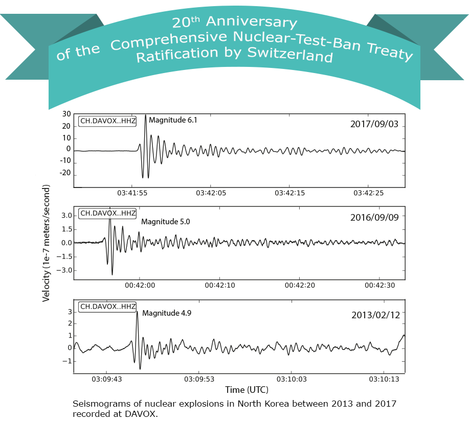
Twenty years of nuclear-test-ban treaty monitoring
On 24 September 1996, the first 71 states signed the Comprehensive Nuclear-Test-Ban Treaty (CTBT) at the United Nations in New York, thereby confirming that they would henceforth refrain from any future nuclear test explosions. Not only was Switzerland one of the first signatories, Geneva as a home of the United Nations also served as a hub for the preparatory negotiations. Exactly 20 years ago, in 1999, the Swiss parliament ratified the Treaty, transposing it into applicable law. So far, nearly 200 states have joined the Comprehensive Nuclear-Test-Ban Treaty Organisation (CTBTO), and 168 of them have already ratified the Treaty. For the Treaty to enter into force, eight more states would need to ratify it. They belong to the group of 44 states that had nuclear reactors in 1996 according to the International Atomic Energy Agency (IAEA).
Read more...The CTBTO is an international organisation based in Vienna that monitors compliance with the Comprehensive Nuclear-Test-Ban Treaty (CTBT). The conviction that the Treaty could be reliably monitored was crucial to its establishment. At the UN Conference on Disarmament in Geneva, diplomats and scientists held intensive discussions how such a monitoring system should look like. They agreed on a global network of highly sensitive seismological, hydroacoustic, infrasound and radionuclide monitoring stations, all linked to a common data centre. Together with the member states, the CTBTO was tasked with setting up and operating this monitoring system already before the Treaty's entry into force.
One part of this monitoring network is the DAVOX seismic station, which is run by the Swiss Seismological Service (SED) at ETH Zurich on behalf of the Federal Department of Home Affairs and the Federal Department of Foreign Affairs. The station is installed in a remote and seismically quiet location near Davos. At any suspicion of a Treaty violation, the SED immediately makes the data recorded there available to the CTBTO. The DAVOX station picked up all six of North Korea's presumed nuclear weapons tests, the most recent of which occurred in 2017. It takes about 12 minutes for the signals from explosions in North Korea to reach DAVOX as seismic waves. However, distinguishing a nuclear test from a conventional explosion also requires the other components of the monitoring system, especially the radionuclide stations. In addition to seismic monitoring, the SED actively participates in CTBTO working groups that govern data exchange, technical developments or aspects of quality control.
To mark the 20th anniversary of Switzerland's ratification of the CTBT and raise awareness of the CTBTO and the important role it plays in global security, its Executive Secretary, Lassina Zerbo, is visiting Switzerland. On 4 November 2019, he will give a lecture entitled "Science Meets Diplomacy and World Security - the Case of the Comprehensive Nuclear-Test-Ban Treaty" in the main auditorium (Audimax) of ETH Zurich. This public event will begin at 17:30. Admission is free. Please register here for the event.
A small exhibition on the CTBTO and Switzerland's contribution to nuclear-test-ban treaty monitoring will be on show from 28 October to 5 November in the focusTerra museum.
2019-10-30
[Available in DE] Erdbeben bei Vaduz
Am Mittwoch, dem 30. Oktober 2019 hat sich um 23:08 Uhr (Lokalzeit) östlich von Vaduz, Lichtenstein, in einer Tiefe von ungefähr 4 km ein Erdbeben der Magnitude 2.8 ereignet.
Die Erschütterungen waren vorwiegend im Gebiet um Vaduz, in Schaan, Triesen und Buchs (SG) gut zu spüren. Zudem haben Personen aus weiteren Gemeinden, vorwiegend im Rheintal, das Beben wahrgenommen. Bis Donnerstagmorgen sind beim Schweizer Erdbebendienst an der ETH Zürich etwa 140 Meldungen aus der Bevölkerung eingegangen. Bei einem Erdbeben dieser Stärke sind in der Regel keine Schäden zu erwarten.
Read more...Die letzten spürbaren Beben im Gebiet um Vaduz wurden am 17. Januar 2009 mit einer Magnitude von 3.0 und am 2. Februar 2009 mit einer Magnitude von 2.9, in einer ähnlich geringen Tiefe wie das Beben von Mittwochnacht, registriert.
![[Available in DE] Erdbeben bei Vaduz [Available in DE] Erdbeben bei Vaduz](/export/sites/sedsite/home/.galleries/img_news_2019/Vaduz_shakemap_de.png_2063069299.png)
2019-10-11
Research project funded to better understand earthquakes
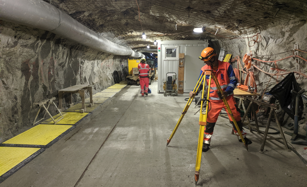
Despite intensive research, scientists cannot predict exactly when and where the next major earthquake will occur. Domenico Giardini, ETH Professor of Seismology and Geodynamics, Florian Amann of RWTH Aachen University, Stefan Wiemer, Director of the Swiss Seismological Service at ETH Zurich, and Massimo Cocco of the Instituto Nazionale di Geofisica e Vulcanologia, Italy, want to better understand the physics of earthquake processes with their ERC Synergy project "FEAR".
The rock laboratory "Bedretto Lab" in the Swiss Alps, built by ETH Zurich and the Werner Siemens Foundation, offers FEAR a unique research environment. The researchers will generate small earthquakes under controlled conditions at a depth of more than one kilometre and on a scale of ten to one hundred metres. They will measure a variety of earthquake parameters using a dense sensor network and then analyse them. The consortium hopes to gain a better understanding of the dynamics of earthquakes. The new findings will also be used to advance experiments on the safe use of geo-energy and to improve the predictability of earthquakes.
2019-10-09
Was that the main quake?
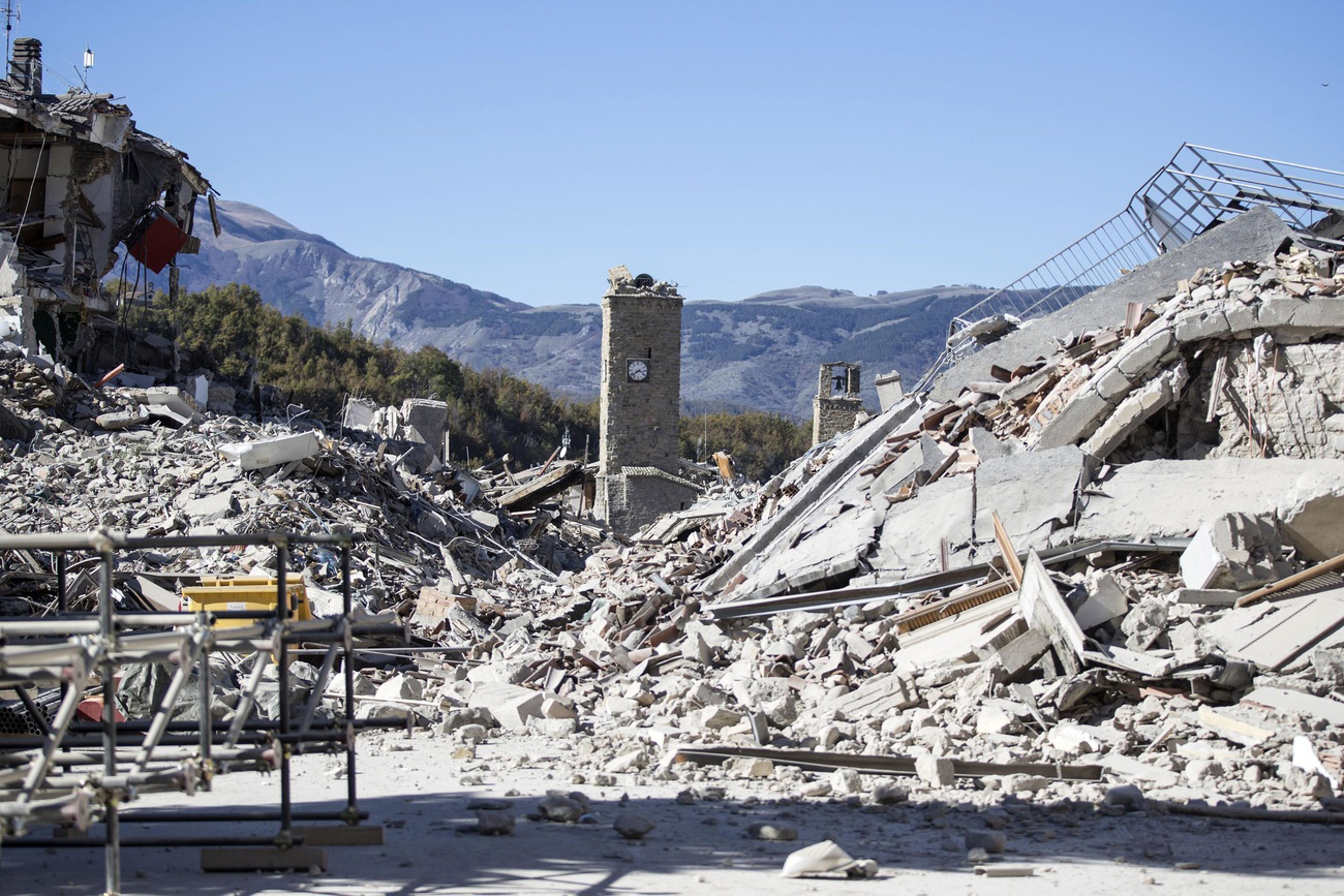
Whereas most major earthquakes are not preceded by foreshocks, they are always followed by thousands of aftershocks, whose frequency and magnitude fade over time. However, in some cases a major earthquake is followed by an even more powerful one. This was what happened in the sequences of earthquakes that hit Central Italy in 2016 or Ridgecrest, California (USA) in July 2019.
Up to now, there was no way of predicting whether a powerful earthquake was likely to be followed by one of even greater magnitude. But the results of a study recently published in Nature by Laura Gulia and Stefan Wiemer from the Swiss Seismological Service (SED) at ETH Zurich awaken hopes that we will soon be able to do just that, in real time. Such a scientific discovery would have far-reaching consequences for civil protection, enabling more reliable decisions about evacuating people, allowing rescue workers to target their efforts accordingly, and permitting the implementation of measures to secure critical infrastructure, such as power stations.
Read more...Based on recent seismic data, the authors of the study have devised a method that can be used to determine whether a sequence of earthquakes is rather ending or will be followed by an even more powerful earthquake. The relevant parameter they examined was the so-called b-value, which characterises the relationship between the magnitude and number of quakes. Laboratory measurements show that this value indirectly indicates the state of stress in the Earth's crust. In seismically active regions the b-value is usually close to 1, meaning that there are about 10 times as many magnitude 3 earthquakes than quakes with a magnitude of 4 or higher.
The researchers have now demonstrated that the b-value changes systematically in the course of an earthquake sequence. To prove this, they examined data from 58 sequences and came up with a traffic-light system indicating what would happen next. When the b-value drops by 10 percent or more, the traffic light turns red, suggesting acute danger of an even more powerful quake. In most cases, though, the b-value rises by 10 percent or more and the traffic light turns green, giving the all-clear by predicting a typical sequence that will gradually fade away. This happened in 80 percent of the sequences captured in datasets examined by the researchers. The traffic light shows amber when the b-value rises or falls by less than 10 percent, meaning it is unclear what will happen next.
The traffic-light system devised by the researchers turned out to be accurate in 95 percent of the cases they examined. The observed change in the b-value betrayed how a sequence would develop, indicating whether or not an even more powerful earthquake would follow. That said, their findings will have to be verified by examining other datasets before such a system can actually be used for civil protection. The system's successful deployment would also require a dense seismic network and corresponding data processing capacity. By no means all regions that could benefit from such a traffic-light system currently have these things.
Nature article Real-time discrimination of earthquake foreshocks and aftershocks
2019-09-25
Swiss contribution to advance the ShakeAlert earthquake early warning system in the U. S.
Imagine receiving a warning about imminent earthquake shaking before you feel it. Sounds like science fiction? Not quite: In Japan and Mexico such systems are established and in operation for several years. Along the West Coast of the United States such a system, called ShakeAlert, is currently in the first phase of a public roll-out. The US Geological Survey (USGS) awarded funding to several institutions, including the Swiss Seismological Service (SED) at ETH Zurich, to get ShakeAlert ready for public alerting.
ShakeAlert is an earthquake early warning system for the West Coast of the United States. It has been developed over a period of 13 years and is currently being tested by selected commercial and institutional users. In a next step, with the additional funding awarded by the USGS, ShakeAlert will be made publicly available to a much larger group that will, for example, be alerted via cell phones. This requires improvement of ShakeAlert in several ways: for example, the upgrade of sensor networks, the advancement of algorithms, and public education.
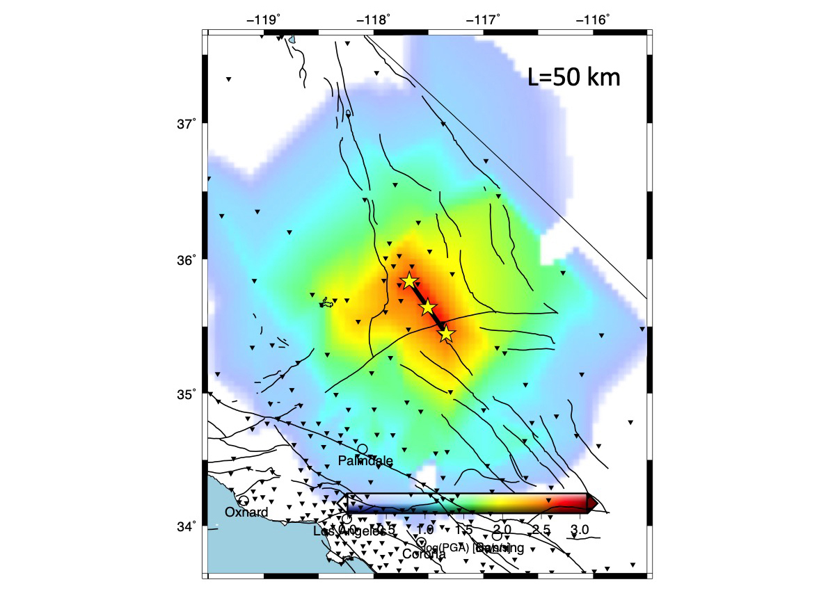
Read more...ShakeAlert uses two algorithms: EPIC and FinDer. EPIC estimates the (point-source) hypocenter and the magnitude of the earthquake. With stronger earthquakes (magnitude 6 and larger), the fault rupture typically spans several tens to hundreds of kilometres. This is why ShakeAlert uses the second algorithm, FinDer. This algorithm is able to estimate in real-time the dimensions of the rupture zone along a fault, which is crucial to estimate the ground shaking as accurately as possible. Maren Böse, a senior research scientist at the Swiss Seismological Service, has developed FinDer. The USGS awarded her to conduct research to improve the performance of FinDer in collaboration with the USGS and California Institute of Technology (Caltech). Her research will focus in particular on the mitigation of large earthquakes along the San Andreas Fault and the Cascadia subduction-zone, which have huge damage potential.
Earthquake early warning systems like ShakeAlert do not predict earthquakes, but rather indicate that an earthquake has begun and that shaking is imminent. This gives people, at best, a precious few to several tens of seconds to take actions before the shaking begins. Early warning systems can also trigger automated actions, such as slowing down trains or stopping elevators. However, there is often not enough time to issue a warning in time. In addition, people who are directly at the epicentre do not benefit from a warning, as the damaging waves arrive before.
Learn more about earthquake early warning and FinDer.
Learn more about ShakeAlert here.
Figure: FinDer line-source model for the 6 July 2019 M7.1 Ridgecrest earthquake, California (USA).
2019-09-05
[Available in DE/FR] Erneut verspürtes Beben bei Konstanz
Am Donnerstag, 05.09.2019 um 16.19 Uhr (Lokalzeit; genau eine Woche nach dem Beben mit einer Magnitude von 3.5 im selben Gebiet ) hat sich ein erneutes Beben, diesmal mit einer Magnitude von 3.0, auf dem Bodanrück ereignet. Das Beben ereignete sich in einer Tiefe von ungefähr 5 km. Bei Beben dieser Stärke sind in der Regel keine Schäden zu erwarten. Seit dem 30.07.2019 haben sich auf der Halbinsel Bodanrück fünf Beben mit einer Magnitude 3.0 oder grösser ereignet.
Das Beben ist Teil einer derzeit aktiven Erdbebensequenz auf der Halbinsel, die etwa 10 km nordwestlich von Konstanz (D) liegt. Das bisher stärkste Beben mit einer Magnitude von 3.7 ereignete sich am 30. Juli 2019. Diesem Hauptbeben ging ein spürbares Beben der Stärke 2.9 voraus. In der Folge wurden einige Nachbeben registriert.
Weitere Informationen zur Erdbebensequenz auf der Halbinsel Bodanrück finden Sie in diesem Beitrag.
![[Available in DE/FR] Erneut verspürtes Beben bei Konstanz [Available in DE/FR] Erneut verspürtes Beben bei Konstanz](/export/sites/sedsite/home/.galleries/img_news_2019/konstanz_20190509.png_2063069299.png)
2019-08-23
[Available in DE/FR] Erdbeben im Val d’Anniviers
Am Freitag, dem 23. August 2019 hat sich um 10:38 Uhr (Lokalzeit) westlich von Vissoie im Val d’Anniviers, südlich von Siders, in einer Tiefe von ungefähr 5 km ein Erdbeben der Magnitude 3.0 ereignet.
Die Erschütterungen waren im Zentralwallis, vor allem im Rhonetal, gut zu spüren. In den ersten Minuten nach dem Erdbeben gingen beim Schweizerischen Erdbebendienst an der ETH Zürich bereits über 50 Verspürtmeldungen ein. Die Bodenbeschaffenheit im Rhonetal (weiche Sedimente) und die damit verbundene Verstärkung der Erdbebenwellen sind dabei für die verbreitete Wahrnehmung mitverantwortlich. Vom Val d’Anniviers selber kamen nur wenige Meldungen. Bei einem Erdbeben dieser Stärke sind keine Schäden zu erwarten.
Read more...In der Region um Vissoie hat der Schweizerische Erdbebendienst an der ETH Zürich im letzten Monat zwei schwache, nicht spürbare Beben registriert. Das letzte verspürte Beben in der Region von Vissoie ereignete sich vor mehr als 15 Jahren, am 20. März 2002. Es hatte eine Magnitude von 2.9. Wie auch nördlich des Rhonetals erstreckt sich hier, in etwa 10 km Abstand zur Talachse, ein Gebiet mit erhöhter seismischer Aktivität parallel zum Rhonetal. Im Unterschied zur Nordseite ist dieses aber räumlich weniger gut abgegrenzt und weniger aktiv. Im Vergleich dazu ereignen sich direkt unter dem Rhonetal weniger Beben.
![[Available in DE/FR] Erdbeben im Val d’Anniviers [Available in DE/FR] Erdbeben im Val d’Anniviers](/export/sites/sedsite/home/.galleries/img_news_2019/20190823_D_Map.gif_2063069299.gif)
2019-08-14
Investigating earthquake myths
Do you believe all Swiss buildings are earthquake-proof? Check your knowledge of earthquake myths at Scientifica and visit the interactive exhibition wall and the Adventure Room provided by the Swiss Seismological Service (SED) at the ETH Zurich. This festival of knowledge will take place from 30 August to 1 September 2019, focusing on the topic "Science Fiction – Science Facts".
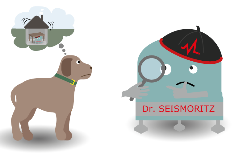
A great deal is known today about the causes and effects of earthquakes, but a number of misconceptions persist, such as the notion that dogs can sense earthquakes before people feel them. SED Director Professor Stefan Wiemer probes that myth in this video. You can explore other myths on our interactive exhibition wall and find out what is fact and what is fiction.
For a more interactive examination of earthquakes, go directly to our stand and put your name down for our second activity: the Adventure Room! An alarming warning circulating on social media claims that a major earthquake is due to hit Zurich in just 15 minutes' time! You happen to be near the office of the famous seismologist, Dr Seismoritz, but he's nowhere to be seen, so you have to take over as crisis manager. In an Adventure Room, you have to find clues and solve all kinds of puzzles or riddles. Like in a scavenger hunt, solving one clue leads to the next.
2019-07-30
[Available in DE/FR] Verspürte Erdbeben bei Konstanz (D)
Am Dienstag, dem 30. Juli 2019, ereignete sich um 01:17 Uhr (Lokalzeit) auf der Halbinsel Bodanrück, etwa 10 km nordwestlich von Konstanz (D), ein Erdbeben der Stärke 3.7. Der Erdbebenherd lag in einer Tiefe von ca. 4 km. Es handelt sich damit um das stärkste bisher aufgezeichnete Beben auf der Halbinsel, die in jüngster Vergangenheit kaum seismisch aktiv war. Das letzte spürbare Beben ereignete sich 1976 in unmittelbarer Nähe zum heutigen Beben, mit einer Stärke von 2.6.
Dem Magnitude-3.7-Hauptbeben ging ein spürbares Beben der Stärke 2.9 um 01:06 Uhr voraus. In der Folge wurden einige Nachbeben registriert. Das stärkste wies eine Magnitude von 3.2 auf und ereignete sich um 02.42 Uhr. Für dieses sowie ein weiteres sind ebenfalls einige Verspürtmeldungen aus der Bevölkerung eingegangen. Insgesamt erhielt der Schweizerische Erdbebendienst (SED) an der ETH Zürich bis in die Morgenstunden etwa 50 Verspürtmeldungen. Bei einem Erdbeben dieser Stärke und der geringen Tiefe sind vereinzelt leichte Schäden in der Nähe des Epizentrums nicht auszuschliessen.
Alle Beben weisen eine Herdtiefe von 4 bis 5 km auf, was für die Region ungewöhnlich nahe an der Oberfläche ist. Abgesehen von einer kleineren Bebenserie in Singen (D) im Jahr 2016 mit Herdtiefen von 5 bis 7 km, ereignen sich die Beben in dieser Region gewöhnlich in Tiefen von 10 bis 25 km. Die Tiefe eines Bebens hat einen Einfluss auf die Auswirkung an der Oberfläche. Beben nahe der Oberfläche werden lokal stärker verspürt. Sie können zudem in sehr seltenen Fällen bereits ab Magnituden von 3.5 kleinere Schäden anrichten. Normalerweise sind solche Schäden erst ab einer Magnitude von 4.5 zu erwarten, also bei Beben die 30-mal mehr Energie freisetzen. Tiefere Beben werden dagegen vergleichsweise weniger stark verspürt, dafür in einem grösseren Umkreis. Einen ebenfalls grossen Einfluss auf die Auswirkungen eines Bebens hat der lokale Untergrund. Auf weichem Sedimentgestein beziehungsweise nicht sehr festem Gestein bei Seen oder Flüssen verstärken sich die Erdbebenwellen teils um ein Mehrfaches verglichen mit einem festeren, felsigen Untergrund.
Eine Sequenz von Beben, wie sie sich in der Nacht vom 29. auf den 30 Juli 2019 ereignet hat, ist nichts Aussergewöhnliches. In ihrer bisherigen Abfolge von Vor-, Haupt- und Nachbeben gilt sie bisher beinahe als Lehrbuchbeispiel. Ihr weiterer Verlauf lässt sich dennoch nicht vorhersagen. Grundsätzlich sind in den nächsten Stunden und Tagen in der Region weitere Beben möglich, die unter Umständen ebenfalls verspürt werden können. Beben mit einer ähnlichen oder gar grösseren Magnitude sind zwar unwahrscheinlich, aber nicht auszuschliessen.
Erdbeben der Magnitude 3.5 bis 4 treten im Durchschnitt in der Schweiz und im grenznahen Ausland etwa 1- bis 5-mal pro Jahr auf.
2019-06-12
[Available in DE/FR] Erdbebenland Schweiz: Informationsanlass für Behörden
Was ist bezüglich Erdbeben zu tun? Eine Frage, die sich in Gemeinden und Kantonen immer wieder stellt. Oft gibt es nur wenige Berührungspunkte mit dem Thema Erdbeben, zum Beispiel im Rahmen von Bauvorhaben, Bewilligungsverfahren oder wenn die Behörden definieren, wie sie mit solchen Ereignissen umgehen.
Der Informationsanlass richtet sich an Behördenvertreter, die sich nicht schwerpunktmässig mit Fragestellungen rund um Erdbeben befassen, aber mehr darüber erfahren möchten. Ziel ist es, eine breite Wissensgrundlage zu vermitteln, die bei Entscheidungen in Bezug auf das Erdbebenrisikomanagement hilft. Das detaillierte Programm finden Sie hier.
Der Anlass findet am 23. August 2019 an der ETH Zürich statt. Anmeldung bis 5. August unter folgendem Link: bit.ly/2GSPvLO
![[Available in DE/FR] Erdbebenland Schweiz: Informationsanlass für Behörden [Available in DE/FR] Erdbebenland Schweiz: Informationsanlass für Behörden](/export/sites/sedsite/home/.galleries/img_news_2019/Erdbebenland_Schweiz_web.png_2063069299.png)
2019-06-05
Using seismometers to monitor rapid mass movements
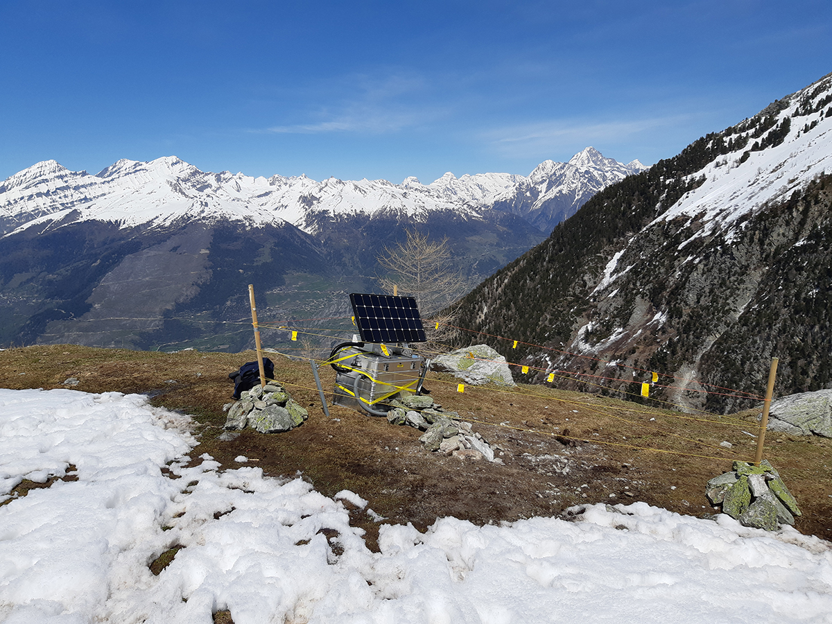
Above the village of Susten in the Canton of Valais, a stream is carving its way through a fascinating geological formation called 'the Illgraben'. Rock masses, both large and small, are constantly coming loose and falling away from the steep slopes of the gorge. Several times a year, mostly after precipitation, this creates a mushy mixture of sliding rocks, mud and water. These mudslides also rip out large blocks of limestone and quartzite and move down the valley at high speed as far as the River Rotten. Usually, no damage is caused near the Illgraben. In other places, in extreme cases mudslides move millions of cubic metres of rock distances of several kilometres. If these mudslides hit transport routes or human settlements, as happened in 2017 with the debris flow at Pizzo Cengalo, for example, the effects can be devastating. Sophisticated measuring systems can help to gain a better understanding of, or even predict, such processes. Researchers from the Swiss Seismological Service (SED), ETH Zurich's Laboratory of Hydraulics, Hydrology and Glaciology (VAW) and the Swiss Federal Institute for Forest, Snow and Landscape Research (WSL) are investigating this at the Illgraben site.
Read more...Predicting large mass movements is no easy matter. Indications of a potentially threatening event are hard to measure, the underlying physical processes are poorly understood and the affected areas can often only be accessed with difficulty. In remote alpine valleys, it is already quite a challenge to ascertain whether an event has even taken place because the spatiotemporal coverage offered by existing monitoring methods (e.g. satellites or geodetic instruments) is insufficient. Local seismic measurement networks offer a hitherto little-used alternative. Mudslides, rockfalls or rock avalanches trigger ground motion. Depending on the size of events, seismic stations can detect the associated movements from several kilometres away and in rare cases even up to several thousand kilometres away. Locally condensing the seismic network and ensuring fast data transmission can improve the monitoring of vulnerable areas and possibly warn of dangerous mass movements. Since 2017, for research purposes the SED has been running such a network including additional measuring instruments in the Illgraben. The knowledge gained from this should help to monitor and predict mass movements better and more reliably in the future.
Further information: Prof. Dr. Fabian Walter at VAW at ETH Zurich.
2019-05-28
[Available in DE/FR] Beben am Südufer des Genfersees
Am Dienstag, dem 28. Mai 2019, hat sich um 10:48 Uhr (Lokalzeit) am Südufer des Genfersees, südwestlich von St. Gingolph, westlich von Novel, auf französischem Boden in einer Tiefe von ungefähr 2 km ein Erdbeben der Magnitude 4.2 ereignet.
Die Erschütterungen waren im ganzen Seebecken und im Chablais gut zu spüren. Da sich das Beben relativ nahe der Erdoberfläche ereignet hat, wurde es vor allem im Gebiet des Epizentrums relativ deutlich verspürt. Die Anzahl der Erdbebenmeldungen nahm entsprechend mit der Distanz ab. Leichte Schäden sind bei einem Beben dieser Stärke vereinzelt möglich.
Read more...In den vergangenen Jahren haben sich in diesem Gebiet wiederholt oberflächennahe Beben oder Erdbebenschwärme ereignet, von denen die stärksten leicht verspürt wurden. Am 22. Dezember 2016 haben sich zum Beispiel in der Nähe des Ortes Novel zwei Erdbeben der Magnituden 3.0 und 3.4 innerhalb von 26 Minuten ereignet, die ebenfalls im Gebiet des Genfersees und im Rhonetal verspürt wurden. Damals haben sich innerhalb von zwei Wochen 13 weitere Erdbeben mit Magnituden zwischen 1.0 und 2.9 ereignet.
Das heutige Beben war damit das stärkste bisher. Mit Nachbeben ist in den nächsten Tagen und Wochen zu rechnen. Gleich starke oder gar stärkere Beben sind unwahrscheinlich, können aber nicht ausgeschlossen werden.
Der Erdbebendienst wird in der Region im Laufe des Tages noch zwei weitere Messstationen installieren um die Nachbeben genauer zu beobachten.
![[Available in DE/FR] Beben am Südufer des Genfersees [Available in DE/FR] Beben am Südufer des Genfersees](/export/sites/sedsite/home/.galleries/img_news_2019/st.gingolph_20190528_en.PNG_2063069299.png)
2019-05-24
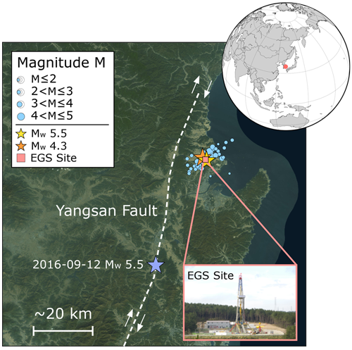
Earthquakes and geothermal energy: lessons from Pohang
In November 2017, a magnitude 5.5 earthquake shook the South Korean city of Pohang, injuring over 100 people and causing $300 million worth of damage. Just a short time later, suspicion arose that the quake might have been triggered by a nearby geothermal project. This impression was backed up by two scientific studies, one of which was written by employees of the Swiss Seismological Service (SED) at ETH Zurich (see the news article dated 26/04/2018). As a result, the South Korean government set up an international expert commission, whose members include Professor Domenico Giardini from ETH Zurich. This commission's recently published final report confirms that the geothermal project was indeed the cause of that highly destructive earthquake.
Read more...The commission examined the tectonic stress conditions, local geology, induced seismicity, drill data and details of the hydraulic stimulations associated with the geothermal project in Pohang, which was intended to construct a heat exchanger 4-5 km down in the crystalline bedrock. A similar petrothermal geothermal energy project was also attempted in Basel in 2006. Projects like this entail pumping fluid into the ground under high pressure. As expected, this triggers numerous minor quakes. Unnoticed by the operators, these injections in Pohang repeatedly set off earthquakes in quite a large previously unknown fault zone. This weakened the apparently tectonically pre-stressed fault line, leading to the magnitude 5.5 earthquake. Now that the causal link has been proved, the expert commission is asking what lessons can be learnt from the occurrence.
Its verdict on the project is far from positive. Indeed, looking back it can pinpoint failings at all stages of the undertaking. Before work began, geological studies had shown that some fractures were critically pre-stressed. Bearing in mind the proximity to a medium-sized city with a major industrial port, this finding should have prompted an adjustment of the project's risk assessment. Then the first hydraulic stimulations began at borehole PX-2. The geological reports state that large quantities of the fluid pumped into PX-2 seeped away. This is unusual, constituting another alarm signal, an indication that the borehole ran through a sizeable interference zone. Locally, the spillage of the injected fluid increased the pressure on the fault zone and already triggered numerous small earthquakes early on. Yet this increased induced seismicity was only analysed after the magnitude 5.5 earthquake.
The commission also looks into the two-month period between the last hydraulic stimulations and the damaging quake. This time lag has repeatedly been interpreted as indicative of no connection between the geothermal project and the earthquake. However, the report invokes findings from other projects which prove that induced seismicity often does not stop when hydraulic stimulations come to an end. The commission recommends involving the respective authorities and all relevant experts in the run-up to future projects, to draw up a comprehensive risk analysis and then keep it constantly updated. Furthermore, a reliable real-time monitoring system has to be set up, the processes and injection strategy must be constantly reviewed and, if need be, corrected, and risk mitigation measures need to be formally noted down and communicated.
Shortly after the earthquake in Pohang, the canton of Jura called for a review of the risk analysis for the planned petrothermal geothermal energy project in Haut-Sorne. The operator, Geo-Energie Suisse, has written an appraisal, which the SED is currently examining on behalf of the canton, taking account of all the known findings from Pohang. The SED is also involved in research work at the Bedretto Underground Laboratory for Geoenergies. There, along with other national and international partners, ETH Zurich, is conducting research to ascertain whether geothermal energy can be exploited safely, efficiently and sustainably using any existing technologies or procedures.
Science article "Managing injection-induced seismic risk"
Report by the commission (in Korean and English – scroll down and click on link to PDF file)
Science article "The November 2017 Mw 5.5 Pohang earthquake: A possible case of induced seismicity in South Korea"
2019-05-15
Seismic water feature
You don't need to go far to watch the ocean waves. The water feature of the fountain at the seaside resort of Enge in Zurich shows how the waves of the Atlantic, the Mediterranean or the Baltic Sea are behaving, in real time. At least, this is the signal most frequently transmitted to the fountain's control system by the Swiss Seismological Service's seismic station at ETH Zurich in Degenried, near the Dolder. Roughly once a week, the dynamics of the fountain change, whenever a major earthquake occurs somewhere in the world. With a bit of luck you might even see smaller-scale Swiss earthquakes.
Although Switzerland's seismic network, comprising over 200 stations, is designed to record earthquakes, it can actually do much more. In addition to capturing the movements of ocean waves, the highly sensitive measuring devices detect the sounds emanating from forests, the noise made by flowing traffic and explosions in quarries. The Swiss Seismological Service (SED) only systematically analyses recorded seismic data after earthquakes and explosions. The Aquaretum, the fountain in Lake Zurich, uses a small frequency range of the existing signal, which causes the harmonic motion of the fountain's jets of water.
Read more...In all, 12 water jets propel the water shoots up to heights of as much as 35 metres. They are arranged in four groups of three, representing the acceleration, speed and path of the transmitted signal respectively. These three parameters are also fundamental for analysing seismological data.
The Aquaretum was gifted to population and visitors of Zurich by the Zurich Insurance Group and made with the support of Fischer Architekten, the sound artist Andres Bosshard and the team from Metallatelier.
2019-04-25
The underground rock laboratory where even the smallest quakes are of interest
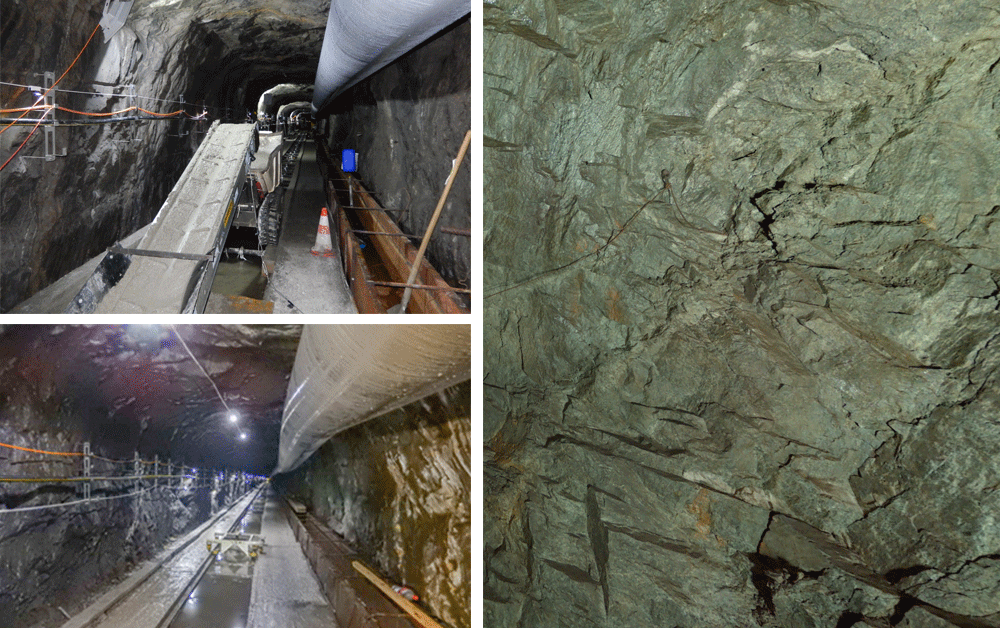
A unique research facility, the "Bedretto Underground Laboratory for Geoenergies", in the Bedretto valley in the Canton of Ticino is currently nearing completion. Together with national and international partners, ETH Zurich will investigate technologies and processes that should enable the safe, efficient, long-term use of geothermal energy. The Swiss Seismological Service at ETH Zurich is installing seven additional seismic stations in and around the rock laboratory. These instruments will be sensitive enough to record even the minutest tremors in the surrounding area.
The Bedretto Lab will be inaugurated on 18 May 2019. Take the opportunity to visit this unique rock laboratory and explore the history of the Alps deep inside a mountain. What's more, in front of the entrance tunnel leading to the lab you can learn more about the work that will be done there, test your knowledge by completing a rock quiz, see how core samples are produced and acquaint yourself with the various measuring systems used.
Register here for a free tour (in German or Italian).
2019-04-23
First potential marsquakes detected
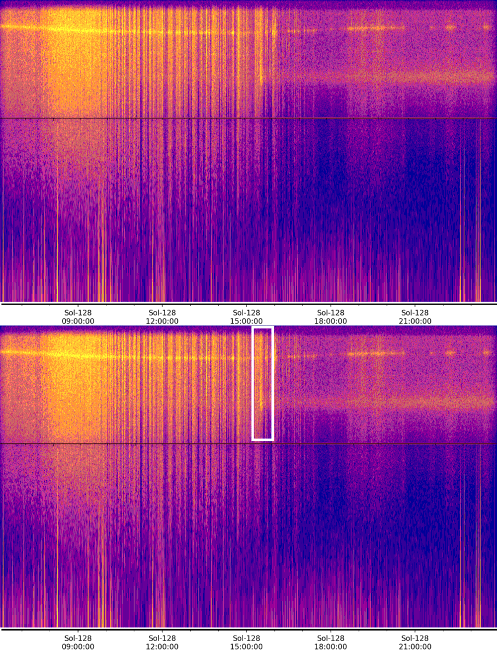
On 19 December 2018, the NASA InSight mission placed a seismometer on the surface of Mars. It aims to record marsquakes in order to to gain a better understanding of the planet’s interior. Since the very first day, the data recorded is continuously scrutinized by the Marsquake Service led by ETH Zurich, operated by the Seismology and Geodynamics group and the Swiss Seismological Service. At first, the data mostly showed the frequency and intensity of dust devils, whirlwinds which are very common on Mars. This already proved that the seismometer was performing well. On 6 April 2019 (Sol 128, 15:32 local Mars time), researchers from ETH on duty for the Marsquake Service discovered a potential marsquake in the data. It is the first signal that appears to have come from inside Mars, even though its exact cause is still an on-going scientific investigation.
Read more...Three other signals of likely seismic origin occurred on 14 March, 10 April, and 11 April 2019. These signals are more ambiguous to the InSight team than the one on 6 April, but do not appear to be clearly associated with atmospheric disturbances or other known noise sources. They are smaller than the event on 6 April and were only detected by the more sensitive broadband sensors. The team will continue to study these events to try to determine their origin.
Based on these first records, marsquakes seem to be distinct to earthquakes. According to their size and long duration, they are more similar to quakes recorded on the Moon by the Apollo programme. Whereas on Earth plate tectonics is the dominant process that provokes quakes, on the Moon the cooling and contraction causes tremors. The relevant processes at Mars are not yet fully understood. In any case, stress is built up over time until it is strong enough to break the crust. Different materials can change the speed of seismic waves or reflect them, allowing scientists to use these waves to learn about the interior of a planet and model its formation. The events recorded until now are too small to provide useful data on the deep Martian interior. Nevertheless, they mark a milestone of the InSight mission, proving the efficiency of the data processing and analysis capabilities, both developed at ETH Zurich.
2019-02-04
Can deep boreholes trigger earthquakes?
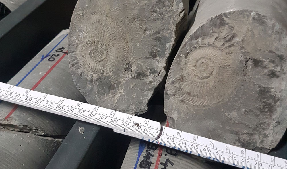
More than 100 deep boreholes have already been drilled to depths of 400 m or more in Switzerland. Among other things, they have served to explore the subsoil, whether for tunnelling, exploiting geothermal energy, as potential sites for final repositories, prospecting for raw materials or tapping into sources of groundwater and thermal water. Hundreds of thousands of such boreholes have been sunk all over the world. So far, to our knowledge, no damaging earthquakes have been triggered solely by drilling deep boreholes. Consequently, the simple answer to the question asked above is that instances of damage caused solely by sinking deep boreholes, without any further interventions in the subsoil, are extremely unlikely. However, micro-earthquakes with magnitudes of less than 1 have been documented in association with the drilling of deep boreholes. Thanks to a dense seismic network, such microquakes can be reliably recorded. It can then be better determined whether such seisms are related to the sinking of deep boreholes or triggered by natural causes.
Read more...Despite the very large number of deep boreholes drilled worldwide, data on earthquakes occurring in connection with them are rather sparse. One reason for this is that the probability of such quakes is very low. Another is that many deep boreholes have been drilled in uninhabited areas, so potentially noticeable quakes may not have been felt and reported by the public. In many places, such boreholes have not been - and are still not being - seismically monitored. Consequently, it is impossible to reliably record smaller induced earthquakes. In Switzerland, for example, a number of microquakes were recorded when the borehole for the Basel geothermal energy project was cemented. The strongest of these had a magnitude of 0.7, meaning that it released 500 times less energy than a magnitude 2.5 quake. Earthquakes above this magnitude can usually be felt.
The physical processes behind earthquakes triggered in certain circumstances by drilling boreholes are well understood. Deep boreholes sometimes alter local stresses and pore pressures in rock, and in some cases this can reactivate a nearby tectonically pre-stressed fracture, causing an earthquake. However, such stress changes usually only occur in the following two situations: firstly, when drilling into a stratum with high fluid pressures. In this case, under certain conditions, the rock fluid (liquid or gas) can find its way into the borehole, causing overpressure that can usually be reduced in a controlled manner. Alternatively, the borehole is sealed at the corresponding place deep underground. Secondly, when boring into a very liquid-permeable stratum or rock of very low strength. If this happens, some of the drilling fluid or cement may enter the surrounding rock. The drilling fluid is needed to bring the drilling dust to the surface and stabilise the borehole during the driving process. Once a section has been drilled, the borehole is lined with cemented pipe to keep it open in the long term. In most cases, though, stress changes only affect small rock volumes. So the probability of activating quite a large, pre-stressed fracture and thus triggering a fairly large, potentially noticeable earthquake is extremely low.
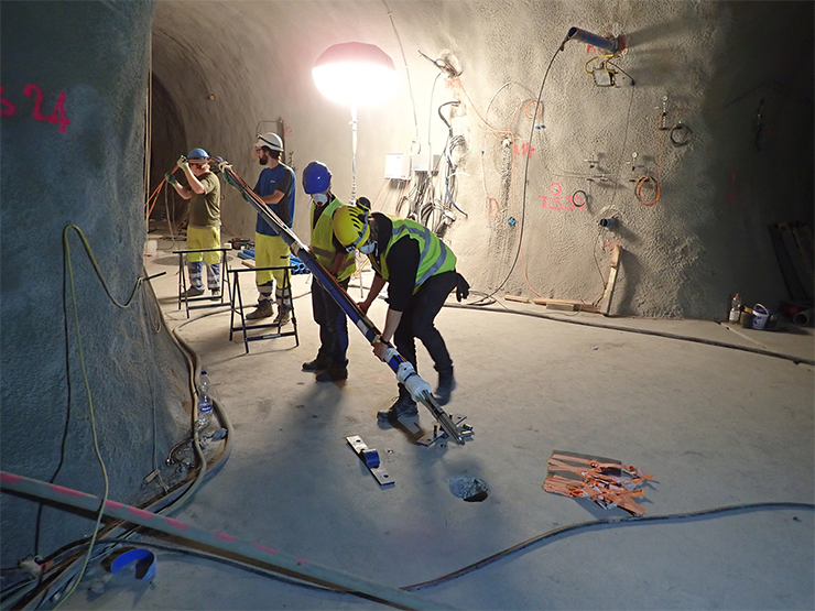
The Swiss Seismological Service (SED) at ETH Zurich does not normally recommend seismic monitoring in its Guide for Managing Induced Seismicity for deep boreholes (e.g. exploratory drilling). Nonetheless, to record evidence and clarify the distinction between natural and induced seismicity, it may make sense to install an additional monitoring station near a drill site. For this very purpose, to cite just one example, the SED is currently consolidating its network on behalf of Switzerland's National Cooperative for the Disposal of Radioactive Waste (Nagra) with a view to monitoring exploratory drilling in northeastern Switzerland.
2019-01-28
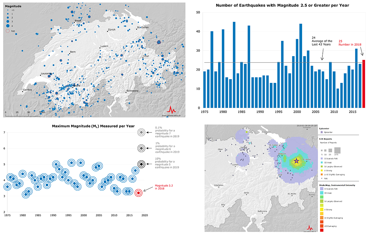
Earthquakes in Switzerland in 2018
Last year, the Swiss Seismological Service (SED) at ETH Zurich recorded more than 900 earthquakes with magnitudes of between -0.2 and 4.1 in Switzerland and its neighbouring countries. 25 of these quakes had a magnitude of 2.5 or more. Earthquakes of this size can usually be felt by the local population. So 2018 goes down as an average earthquake year, albeit one from which we can learn a lot. Because even very small quakes provide valuable information about the subsurface and thus make it easier to estimate future seismic activity.
Thanks to Switzerland's dense and highly sensitive earthquake measuring system, even the smallest quakes almost anywhere in Switzerland can be recorded and analysed. Earthquakes indicate the locations of more (or less) active faults today or over the years and provide insights into fracture processes deep beneath our feet. The seismic waves caused by earthquakes also offer data on the subsurface through which they pass. For example, the speed at which they travel tells something about the physical properties of the rock at the locations in question. These findings contribute towards more accurate risk assessment. So even 'quieter' earthquake years yield valuable knowledge.
Read more...The two strongest earthquakes felt over the largest areas by the Swiss population occurred on 17 January and 1 February 2018 in Austria's Kloster Valley (Montafon) near the Swiss border. Both quakes reached a magnitude of 4.1. The most powerful earthquake in Switzerland itself, with a magnitude of 3.2, occurred on 23 August near the twin-peaked mountain Dents de Morcles in the Canton of Valais. The SED received around 400 reports from people who felt this quake, mainly in the Rhone Valley, whose soft subsurface particularly intensified the shaking. Other earthquakes, some of which were also clearly felt, occurred on 15 and 16 May near Châtel-St-Denis in the Canton of Fribourg (with magnitudes of 3.1 and 2.9), on 3 November near Martigny in the Canton of Valais (magnitude 2.9) and on 29 December near Fribourg (magnitude 2.9). Only the quakes in the Kloster Valley ended up causing minor damage, such as cracks in buildings' façades.
In addition, last year saw the occurrence of some remarkable earthquake swarms. A swarm entails numerous quakes occurring over a fairly long period, without there being any clear sequence of foreshocks, mainshock and aftershocks. The most notable swarm involved a series of earthquakes northeast of St. Léonard, near Sion in the Canton of Valais. This sequence was related to a fault that has repeatedly been associated with phases of heightened seismic activity since 2014. It is believed to be part of the Rhone-Simplon fault, which appears to be broken into separate segments in this area. Another earthquake sequence worth mentioning occurred in the border area between Italy, France and Switzerland, in the east of the Mont Blanc Massif. Last year, the SED pinpointed the locations of close to 100 earthquakes with magnitudes between 0 and 2.2 in that area.
In general, in 2018, as in previous years, most earthquake activity occurred in the Valais region, the Canton of Graubünden and the areas along the Alpine front. Despite this concentration of seismic activity, historically it has been shown that no parts of Switzerland are earthquake-free regions. Based on the long-term average, a serious earthquake with a magnitude of 6 or more occurs in the earthquake country Switzerland every 50 to 150 years.
2019-01-17
Experiment investigates how faulted rock retains CO2
In order to achieve the ambitious UN climate targets, it is not enough to reduce greenhouse gas emissions. As a complementary option, one can capture CO2 directly from industrial production or from the atmosphere and store it permanently in the deep underground. For enabling so-called negative emissions, sequestrated CO2 needs to be safely retained for centuries. Once injected into a reservoir, CO2 may escape again in two ways: through existing boreholes or through existing faults in the rock above the reservoir meant to seal it. Faults in this caprock may not only influence the long-term containment of CO2. They are also the place, where earthquakes may occur.
Read more...Currently, the physical and chemical parameters governing leakage through faults, and the effects of rock deformation and chemical interactions leading to induced seismicity, are not fully understood. There is further limited knowledge on Swiss-specific conditions, making it difficult to judge to what extent underground CO2 storage could be an option in this country. This is why scientists from the Swiss Seismological Service at ETH Zurich and the SCCER-SoE are conducting an experiment, in collaboration with the Department of Mechanical and Process Engineering and the Institute of Geophysics at ETH Zurich as well as Swisstopo and EPFL. The experiment is taking place at the Mont Terri rock laboratory and part of the ELEGANCY project funded by the European Commission and the Swiss Federal Office of Energy.
Scientists will investigate how CO2 migrates withing a rock with faults, under what circumstances induced seismicity may occur, and how such a storage should be monitored best. Therefore, they will inject small amounts of CO2-enriched saltwater into a borehole that cuts through a small fault zone. To study how the fault zone reacts to the CO2 injected, they will observe the stability of the rock and analyse the coupling between fault slip, pore pressure, and fluid migration. Active and passive seismic sensors will monitor the variations of seismic velocities around the injection and register possible micro-earthquakes with magnitudes below zero.
In contrast to a full-scale CO2 storage project, this experiment only investigates the relevant processes with small amounts of CO2-enriched saltwater. Nonetheless, its findings will contribute to a better understanding of the relevant processes influencing the migration of CO2 in faults. Thereby, the experiment will also contribute to an enhanced site characterization. Worldwide, about twenty CO2 storage projects are already in operation, each sequestering up to three million tons of CO2 per year, and numerous plants are in the planning. In Switzerland, there is currently no CO2 storage project planned.
Learn more about the ELEGANCY project:

![[Available in DE/FR] Verspürte Erdbeben bei Konstanz (D) [Available in DE/FR] Verspürte Erdbeben bei Konstanz (D)](/export/sites/sedsite/home/.galleries/img_news_2019/20190730_Beben_Konstanz_DE_web.png_2063069299.png)

