News Archive 2021
2021-12-25
[available in FR/DE] Earthquake in the Ajoie region
Le 25 décembre 2021, à une heure du matin, un tremblement de terre de magnitude 4.1 s’est produit à l’ouest de l’Ajoie, entre Damvant et Réclère, à une profondeur d’environ 6 km. Il a été ressenti largement dans le Jura, et sporadiquement dans le nord-ouest de la Suisse, jusque à Lausanne, Berne, Lucerne et à l’ouest du canton de Zurich. Aucun dégât n’est rapporté jusqu’à présent; d’une manière générale, il ne faut pas s’attendre à de dégâts sérieux pour un séisme d’une telle magnitude.
Depuis la nuit, plusieurs répliques ont été mesurées par le réseau du Service sismologique suisse à l’ETH de Zurich, dont une - avec une magnitude de 3.6 à 15:59 - a été assez forte pour être ressentie par la population locale. D’autres répliques, même perceptibles, ne peuvent être exclues.
La sismicité en Ajoie est relativement basse. Bien que plusieurs petites tremblements de terre y aient été enregistrés dans les décennies passées, celui de Noël est le plus fort depuis plus de 100 ans.
![[available in FR/DE] Earthquake in the Ajoie region [available in FR/DE] Earthquake in the Ajoie region](/export/sites/sedsite/home/.galleries/img_news_2021/Ajoie-engl.png_2063069299.png)
2021-12-22
Swaying mountains
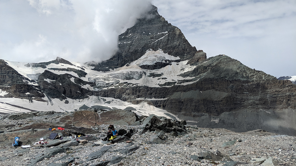
Like bridges and tall buildings, large mountains are constantly vibrating, excited by seismic energy form the Earth. An international team of researchers has now been able to measure the resonant swaying of the Matterhorn and make its motion visible using computer simulations.
The Matterhorn appears as an immovable, massive mountain that has towered over the landscape near Zermatt for thousands of years. A study just published in the journal "Earth and Planetary Science Letters" (https://doi.org/10.1016/j.epsl.2021.117295) now shows that this impression is wrong. An international research team has proven that the Matterhorn is instead constantly in motion, swaying gently back and forth about once every two seconds. This subtle vibration with normally imperceptible amplitudes is stimulated by seismic energy in the Earth originating from the world’s oceans, earthquakes, as well as human activity.
"The movements of the underground cause every object to vibrate, which we fortunately cannot feel, but detect with sensitive measuring instruments," emphasises Donat Fäh from the Swiss Seismological Service at ETH Zurich. These so-called natural frequencies depend primarily on the geometry of the object and its material properties. The phenomenon is also observed in bridges, high-rise buildings, and now even mountains. "We wanted to know whether such resonant vibrations can also be detected on a large mountain like the Matterhorn," says Samuel Weber, who carried out the study during a postdoctoral period at the Technical University of Munich (TUM) and is now working at the WSL Institute for Snow and Avalanche Research SLF. He emphasizes that the interdisciplinary collaboration between researchers at the Swiss Seismological Service at ETH Zurich, the Institute for Computer Engineering and Communication Networks at ETH Zurich, and the Geohazards Research Group at the University of Utah (USA) was particularly important for success of this project.
Read more...High alpine measuring devices
For the study, the scientists installed several seismometers on the Matterhorn, including one directly on the summit at 4,470 meters above sea level and another in the Solvay bivouac, an emergency shelter on the northeast ridge, better known as Hörnligrat. Another measuring station at the foot of the mountain served as a reference. Extensive past experience from Jan Beutel (ETH Zurich / University of Innsbruck) and Samuel Weber installing equipment for measuring rock movements in high mountains made deployment of the measurement network possible. The data are automatically transmitted to the Swiss Seismological Service.
The seismometers recorded all movements of the mountain at high resolution, from which the team could derive the frequency and direction of resonance. The measurements show that the Matterhorn oscillates roughly in a north-south direction at a frequency of 0.42 Hertz, and in an east-west direction at a second, similar frequency. In turn, by speeding up these ambient vibration measurements 80 times, the team was able to make the vibration landscape of the Matterhorn audible to the human ear, translating the resonant frequencies into audible tones.
Amplified vibrations at the summit
Compared to the reference station at the foot of the Matterhorn, measured movements on the summit were up to 14 times stronger in the range of the natural frequency. For most of the team’s data these movements were small, typically in the range of nanometers to micrometers. The increase in ground motion with altitude can be explained by the fact that the summit moves freely while the foot of the mountain is fixed, comparable to a tree swaying in the wind. Such amplification of ground motion on the Matterhorn could also be measured during earthquakes, and the team notes this amplification may have important implications for slope stability in the event of strong seismic shaking. Jeff Moore of the University of Utah, who initiated the study on the Matterhorn, explains: "areas of the mountain experiencing amplified ground motion are likely to be more prone to landslides, rockfall, and rock damage when shaken by a strong earthquake."
Such vibrations are not a peculiarity of the Matterhorn, and the team notes that many mountains are expected to vibrate in a similar manner. Researchers from the Swiss Seismological Service carried out a complementary experiment on the Grosse Mythen as part of the study. This peak in Central Switzerland has a similar shape to the Matterhorn, but is significantly smaller. As expected, the Grosse Mythen vibrates at a frequency around 4 times higher than the Matterhorn, because smaller objects generally vibrate at higher frequencies. The scientists from the University of Utah were then able to simulate resonance of the Matterhorn and Grosse Mythen on the computer making these resonant vibrations visible. Previously, the US scientists have mainly examined smaller objects, such as rock arches in Arches National Park, Utah. "It was exciting to see that our simulation approach also works for a large mountain like the Matterhorn and that the results were confirmed by measurement data," says Jeff Moore.
Samuel Weber, Jan Beutel, Mauro Häusler, Donat Fäh & Jeffrey R. Moore (2021). Spectral amplification of ground motion linked to resonance of large-scale mountain landforms. Earth and Planetary Science Letters, available online 22 December 2021, 11729.
https://doi.org/10.1016/j.epsl.2021.117295
2021-12-22
Merry Christmas and a Happy New Year
Looking back over the past year is always a very personal thing. This year, our mascot Seismorris brings you best wishes for the year ahead and gives you his personal take on the past 12 months.
"In 2021, I was always where the action was: sometimes above ground, sometimes below, in places near and far, by myself or with others – and, once again, most of those meetings took place virtually. Although this opened up new opportunities and allowed me to interact quickly and easily with colleagues from around the globe, I did appreciate my trips in the real world. These took me deep inside the earth's surface several times in 2021, where I got to follow experiments in the BedrettoLab and the Mont Terri rock laboratory. In Iceland, I supported two projects with a seismic measurement campaign, and I travelled several times to Mars to watch the seismometer there at work. I always enjoy meeting people at events such as Scientifica and Future Day, both of which were able to go ahead this year. Looking ahead to next year, I'm particularly excited about the seismic risk model for Switzerland, which the SED is developing in partnership with the Federal Office for the Environment and the Federal Office for Civil Protection. Of course, I also hope there will be no major tremors – even though I've been training hard so that I can run for cover!"
Merry Christmas
Seismorris, Swiss Seismological Service at ETH Zurich

2021-12-18
[Available in DE/IT] Erdbeben zwischen Mailand und Bergamo
Am Samstag, 18. Dezember 2021, ereignete sich um 11:34 Uhr (Ortszeit) ein Erdbeben zwischen Bergamo und Mailand (Italien) mit einer Stärke von 4.4 in einer Tiefe von ca. 26 km.
Das Erdbeben wurde auch in der Schweiz, insbesondere im Tessin, weiträumig verspürt. Beim SED gingen in der Stunde nach dem Beben rund 800 Verspürtmeldungen ein, vereinzelt bis aus 200 km Entfernung. Bei einem Erdbeben dieser Stärke sind lokal Schäden möglich und es muss mit Nachbeben gerechnet werden. Die relativ grosse Tiefe des Bebens erklärt die ausgedehnte Region, in der dieses Beben verspürt wurde.
Die Poebene ist eine seismisch aktive Region in Italien, in der es gelegentlich zu spürbaren Beben kommt. Das letzte grosse Schadensbeben in der näheren Umgebung des Bebens vom 18. Dezember ereignete sich im Jahr 1802 mit einer Magnitude von 5.7.
![[Available in DE/IT] Erdbeben zwischen Mailand und Bergamo [Available in DE/IT] Erdbeben zwischen Mailand und Bergamo](/export/sites/sedsite/home/.galleries/img_news_2021/20211218_bergamo_deutsch.PNG_2063069299.png)
2021-12-11
[Available in DE/FR] Erdbeben südlich von Liestal (BL)
Am Samstag, 11. Dezember 2021, ereignete sich um 00:08 Uhr (Ortzeit) ein Erdbeben mit einer Magnitude von etwa 3.2 bei Arboldswil (BL), rund 8 km südlich von Liestal. Der Erdbebenherd lag in rund 25 km Tiefe. Schäden sind bei einem Erdbeben dieser Stärke in der Regel nicht zu erwarten.
Das Beben wurde im Grossraum Basel sowie am Jura Südfuss weitgehend verspürt; beim Schweizerischen Erdbebendienst an der ETH Zürich sind innerhalb einer Stunde nach dem Ereignis mehr als 300 Meldungen eingetroffen. Die relativ grosse Tiefe des Bebens erklärt die ausgedehnte Region, in der dieses Beben verspürt wurde.
Innerhalb der Schweiz weist die Region Basel nach dem Wallis eine der höchsten Erdbebengefährdungen auf. Im Jahre 1356 ereignete sich das in der Schweiz grösste historisch dokumentierte Erdbeben mit einer Magnitude 6.6 bei Basel.
![[Available in DE/FR] Erdbeben südlich von Liestal (BL) [Available in DE/FR] Erdbeben südlich von Liestal (BL)](/export/sites/sedsite/home/.galleries/img_news_2021/20211211_Liestal.png_2063069299.png)
2021-11-23
Using ambient noise to uncover three billion years of Mars's past
There are two ways to find out what lies deep beneath our feet: you can either drill a hole, or you can use seismic waves to create an image of the subsurface. In recent decades, seismologists have developed and improved techniques that use ambient noise to map structures in the near-surface layers down to a depth of several hundred metres. Using technologies tested on Earth, seismologists have now mapped structures on another planet for the very first time. These analyses provided a glimpse into three billion years of Mars's past, as detailed in a study recently published in Nature Communications.
Read more...Since NASA's InSight mission landed on Mars in November 2018 and installed a seismometer, the Marsquake Service, led by ETH Zurich and involving the Swiss Seismological Service (SED), has been regularly analysing the recorded seismic data. In addition to identifying numerous marsquakes, researchers used these data to make statements about the structure of the planet's interior. They built a profile of the planet's crust, mantle and core but could not yet reveal much about the near-surface structures. However, shallow subsurface is vital to understanding Mars's geological history.
Rather than using marsquake signals to look into the subsurface, the new study utilises the ambient noise recorded at times without marsquakes. On Earth, such noise is generated by ocean waves, wind and human activity. Over the past few decades, the SED has developed methods to analyse ambient noise. These methods are used to define the structure of the local geology and to determine whether the local subsurface tends to attenuate or amplify seismic waves. This information is crucial for determining a site's earthquake hazard and analysing unstable landslide zones on mountains or in lakes.
On Mars, ambient noise is triggered by the wind, which generates seismic waves when interacting with the planet's surface. Based on analyses of this ambient noise, researchers can now image for the first time the shallow subsurface of Mars and study its geological history at depths ranging from a few dozens to two hundred metres. In contrast to Earth, Mars has never been home to any active plate tectonics. The planet has been shaped by phases of active volcanism that covered large areas with basaltic lava plateaus. The new analyses provide now a detailed image of the subsurface at the InSight landing site and show a top layer of three meters sand (regolith) and loose rock about 20 metres thick that has been fissured by thousands of meteorite impacts. Below are layers of lava flows that covered the planet between 1.7 and 3.6 billion years ago. These lava layers are divided by sediments lying at around 30 to 75 metres deep. The seismic image of the layer-cake geological stratification allows researchers to trace, for the very first time, the most important geological events that have occurred at the InSight landing site on Mars over the last three billion years.
When humans land on Mars one day, they need to know what lies under their feet. The question of whether these near-surface layers contain water is, for example, particularly interesting. The results of this latest study demonstrate that established techniques to investigate Earth are helping to answer such questions on Mars.
Hobiger, M., Hallo, M., Schmelzbach, C. et al. The shallow structure of Mars at the InSight landing site from inversion of ambient vibrations. Nat Commun 12, 6756 (2021).
https://doi.org/10.1038/s41467-021-26957-7

2021-11-04
Research in Swiss rock laboratories
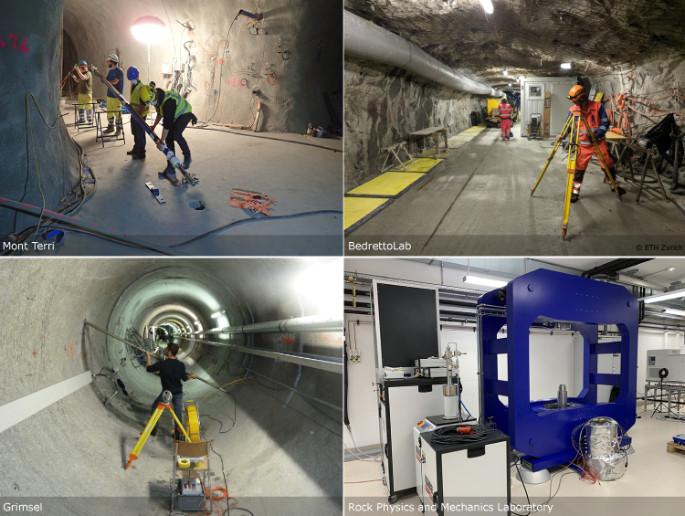
Rock laboratories located deep underground, several hundred metres below the earth's surface, are key research facilities for geoscientists around the world, allowing them to observe geological and physical processes at close range under controlled and reproducible conditions and in great detail. The Swiss Seismological Service (SED) at ETH Zurich also makes use of these laboratories for many of its scientific activities. To mark 25 years of research at the Mont Terri rock laboratory in the canton of Jura, we want to shine the spotlight on this work.
Read more...The SED, as well as other research groups within the ETH Zurich Department of Earth Sciences, is a long-standing partner of the Mont Terri rock laboratory, which has grown from a basic research facility in a side tunnel of the motorway tunnel between Saint-Ursanne and Courgenay into an internationally recognised institution. While research into the storage of radioactive waste was initially the laboratory's primary focus, in recent years work at the facility has increasingly been centred around the underground storage of CO2. The SED has also been active in this field for several years as part of ELEGANCY, a research project funded by the Swiss Federal Office of Energy (SFOE) and the EU intended to investigate whether CO2 extracted from industrial production (from waste incineration plants or the atmosphere, for instance) can be captured and safely stored deep underground permanently, whether in Switzerland or elsewhere. Several such carbon capture and storage (CCS) projects have already been rolled out around the world. One of the challenges here lies in ensuring that CO2 does not slowly migrate to the earth's surface through fault zones (fracture zones deep underground) in the caprock and thus re-enter the atmosphere. To prevent this from occurring, we need a better understanding of the physical and chemical processes that influence whether and how CO2 could escape through fault zones. We also need to look into whether the injected CO2 could trigger microquakes.
To this end, researchers from the SED and partner institutions injected several litres of CO2-enriched saltwater into a fault zone in the Opalinus Clay over a period of several months at varying pressures, using geophysical and geochemical measurement sensors to monitor exactly what was happening in the rock. In principle, Opalinus Clay is an ideal caprock for a CO2 storage facility because it is extremely impermeable to water. Until now, however, it was unclear whether CO2 could migrate through fault zones in the clay. Initial results of the research conducted at Mont Terri show that the CO2 injected near the natural fault zone rises as expected. However, rather than just taking the path of least resistance, i.e. along the fault, it also spreads in the surrounding area in a complex pattern, mixing with the CO2 already present in the fault zone. As such, though CO2 does move towards the earth's surface, it does so very slowly. In addition, the clay swells as soon as it comes into contact with the CO2-saltwater mixture. This causes any cracks to close again, so there are no ways for CO2 to rise. We can therefore assume that Opalinus Clay is a very efficient caprock and that no CO2 would escape from the reservoir for thousands of years. In the medium term, CO2 becomes part of the rock or is mineralised and is then permanently bound. The research findings are currently being prepared for scientific publication. Mont Terri's research thus contributes to achieving the UN climate goals, in which negative emissions using CCS play an important role.
ETH Zurich also operates a rock laboratory in a tunnel deep underground, though this lab focuses on a slightly different field. The BedrettoLab is a research facility located about 1.5 kilometres below the earth's surface and in the middle of a 5.2-kilometre-long tunnel connecting Ticino with the Furka railway tunnel. The lab is home to a number of teams of scientists conducting experimental research, more specifically with a view to developing new methods for creating an efficient heat exchanger deep underground without triggering major perceptible or damaging earthquakes. The researchers also want to intentionally trigger very weak earthquakes with magnitudes of 0 to 1, which cannot be felt by humans, so that they can observe the approximately 10- to 30-metre-long fracture process from a few metres away. These experiments produce new scientific findings for geothermal energy and earthquake physics, as well as new techniques and sensors that can be used in this field. The SED is one of the BedrettoLab's key research partners and is responsible for the seismic monitoring of all activities.
Even before the BedrettoLab opened its doors, the SED was collecting initial, vital data on the connection between geothermal energy and induced earthquakes at another rock laboratory in Switzerland, the Grimsel Test Site. Though on a somewhat smaller scale than in the Bedretto Valley, researchers investigated the physics of induced earthquakes, i.e. quakes stimulated by deep geothermal power projects, for example. The research in rock laboratories is supplemented by small-scale experiments with rock samples performed in the Rock Physics and Mechanics Laboratory at ETH Zurich, where researchers can control the environment better than directly in the rock. In order to advance research, research laboratories – whether in the rock deep below the earth's surface or in ETH's buildings – are key to enabling the scientific community to get to grips with the complex processes under way in the bowels of the earth.
2021-11-02
[Available in DE/FR] Zwei spürbare Erdbeben im Wallis und im französischen Jura
Der Schweizerische Erdbebendienst hat am Abend des 1. November 2021 zwei Erdbeben mit Magnituden von 2.8 und 3.1 registriert. Das erste Beben, mit Magnitude 2.8, ereignete sich um 21.13 Uhr (Lokalzeit) ca. 10 km nördlich von Sion (VS), in einer Tiefe von 5 km. Es wurde in Teilen des Wallis und des Kantons Freiburg deutlich verspürt, aus dem Rhonetal bei Sion gingen über 100 Verspürtmeldungen ein. Das zweite Beben, mit Magnitude 3.1, ereignete sich um 23.15 Uhr (Lokalzeit) 15 km nordöstlich von Le Locle im französischen Jura in einer Tiefe von 14 km. Dieses Beben wurde nur schwach verspürt. Die beiden Beben haben sich in seismotektonisch ganz verschiedenen Regionen ereignet und liegen etwa 120 km voneinander entfernt. Ein Zusammenhang zwischen den Ereignissen kann daher trotz der zeitlichen Nähe ausgeschlossen werden.
Read more...Schäden sind bei Beben dieser Stärke nicht zu erwarten. Falls Sie eines der Beben gespürt haben, können Sie Ihre Beobachtungen unter www.seismo.ethz.ch/earthquakes/did-you-feel-an-earthquake melden.
Spürbare Beben sind im Jura vergleichsweise selten. Im Wallis hingegen werden im langjährigen Mittel ungefähr fünf Beben pro Jahr von der Bevölkerung gespürt. Schadensreiche Beben können grundsätzlich in beiden Regionen jederzeit vorkommen. Sie sind jedoch auch im Wallis, der Region mit der höchsten Erdbebengefährdung in der Schweiz, eher selten. Mit einem starken Beben mit einer Magnitude von 6 oder mehr ist etwa alle 50 bis 150 Jahre zu rechnen. Zuletzt ereigneten sich im Jahr 1946 bei Sierre (VS) ein Beben mit einer Magnitude von 5.8. Wo genau das nächste grössere oder kleinere Beben auftritt, lässt sich nicht vorhersagen.
2021-10-15
Water feature dances to the rhythm of seismic waves
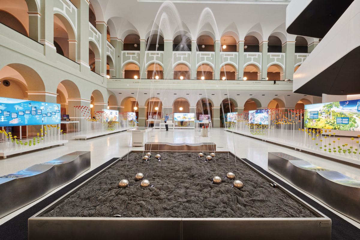
Once used to supply water, fountains today enliven and brighten both public and private spaces. In 'Waves - Dive in!', the new special exhibition from focusTerra, a fountain powered by 12 spherical jets mirrors the dynamics of seismic waves as an artistic expression of their power. Visitors can even pick the fountain's choreography.
Options include real-time signals from the seismic station on the Zürichberg and the focusTerra exhibition, as well as signals from Mars provided by NASA's InSight mission, the 4.6-magnitude earthquake occurring near Linthal in the canton of Glarus in 2017, and the major earthquake that hit Tohoku in Japan in 2011 at a magnitude of 9.1.
Read more...An algorithm translates the various seismic signals to determine the shape and size of the water arcs. The jets are arranged in four groups of three and can propel the water to heights of over 2.5 metres. One jet in each group produces a spray of water representing either the acceleration, speed or path (displacement) of the recorded ground motion. These three parameters are also fundamental for analysing seismological data.
A large version of this water feature can be admired at Zurich's Seebad Enge resort, where the Aquaretum fountain also displays real-time signals from the Zürichberg station. The fountain usually shows how the waves of the Atlantic, the Mediterranean or the Baltic Sea are behaving. The seismic station on the Zürichberg continuously records the vibrations of the ocean waves and instantly transmits these signals to the fountain's control system. Roughly once a week, the dynamics of the water feature briefly change whenever a major earthquake occurs somewhere in the world whose vibrations shake Zurich's geological underground. With a bit of luck, you might even see smaller-scale Swiss earthquakes on the fountain at Lake Zurich and its little sibling at the focusTerra exhibition.
focusTerra's special exhibition 'Waves - Dive in!' will run until 5 March 2023.
More information is available here.
2021-10-05
[Available in DE / FR] Erdbeben bei Arolla (VS)
Am Dienstag, 5. Oktober 2021, ereignete sich um 07:39 Uhr (Ortszeit) ein Erdbeben mit einer Magnitude von 4.1 in der Nähe von Arolla (VS). Der Erdbebenherd lag etwa 2 km unter Meeresniveau unterhalb des Mont Collon. Bei einem flachen Beben dieser Stärke sind kleinere Schäden nahe dem Epizentrum vereinzelt möglich, allerdings ist die Region nicht besiedelt und uns sind bislang keine Schäden berichtet worden. Es gab jedoch mehr als 60 Verspürtmeldungen, darunter ein Grossteil in Zermatt (Epizentraldistanz: 19 km) und Sion (Epizentraldistanz: 31 km).
Read more...Das letzte, ähnlich grosse Ereignis in der Nähe ereignete sich im März 1996 (ebenfalls Magnitude 4.1). Nach einer relativ ruhigen Phase ohne signifikante Erdbeben in den folgenden fast 25 Jahren gab es im September 2020 ein Beben mit einer Magnitude 3.5 und gestern Morgen eines mit einer Magnitude 3.0. Eine erste Analyse deutet darauf hin, dass das Beben Resultat einer in etwa Nord-Süd ausgerichteten schrägen Aufschiebung ist, wie auch schon das Magnitude 3.5 Beben in 2020.
Grundsätzlich sind Erdbeben in dieser Region nichts ungewöhnliches, der Kanton Wallis weist innerhalb der Schweiz die grösste Erdbebengefährdung auf. Es ist zu erwarten, dass in den nächsten Tagen und Wochen kleinere Nachbeben auftreten werden, die möglicherweise auch gespürt werden können. Die Wahrscheinlichkeit, dass in den nächsten Tagen oder Wochen noch ein ähnlich grosses oder grösseres Beben auftritt ist sehr gering, es ist allerdings auch nicht auszuschliessen.
2021-09-15
Fieldwork in Iceland for geothermal energy
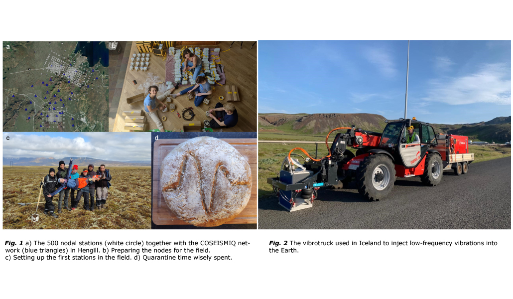
Ten researchers from the Swiss Seismological Service (SED) at ETH Zurich went to Iceland in June and August 2021 to support two projects with a seismic measurement campaign. In a collaborative effort with the German Research Centre for Geoscience (GFZ) and Reykjavik Energy (ON Power), the team set up a network of 500 seismic nodes across the Hengill geothermal field. It is the largest and densest network of measuring stations installed in the country so far.
This fieldwork in Iceland was part of a seismic measurement campaign for a geothermal project in Iceland and "DEEPEN" (DErisking Exploration for geothermal Plays in magmatic ENvironments), a European research project in the field of geothermal energy. DEEPEN aims at establishing an approach to minimise the risk of field exploration in deep geothermal energy and at contributing to a higher probability of success when drilling for geothermal fluids in magmatic systems.
Read more...The seismic nodes that were used are 5Hz geophones with integrated battery and digitiser (SOLOS provided by the University of Geneva) and 5Hz geophones with external digitiser and batteries (provided by the Geophysical Instrument Pool of the GFZ). Data from such dense seismic node deployments allow the researchers to gain a better understanding of the sub-surface. Thanks to the small size of the nodes, the research team finished the deployment within two weeks in June, despite the tough weather condition, steep terrain and long hikes to reach each dedicated site.
With the network, a special focus was given to the Northern region around Nesjavellir and the Southern Hverahlid, where the most productive boreholes of the geothermal field are located. A vehicle called vibrotruck (see fig. 2) passed through the Northern array and provided an additional source signal during the deployment time. Typically used in seismic exploration, the vibrotruck pressed a vibrating plate onto the earth’s surface. The low-frequency vibrations propagate underground and are reflected by the rock strata. These seismic waves were recorded by the installed geophones and gave further insights into the geological sub-surface.
After the deployment, the network was running successfully for two months and overlapped with another seismic network (COSEISMIQ), which is also operated by the SED. In August 2021, the research group travelled again to Iceland to dismantle both networks. The researchers expect that the high-density seismic imaging will allow them to illuminate the sub-surface in unprecedented detail.
2021-08-05
A better understanding of slow slips offers insights into earthquakes
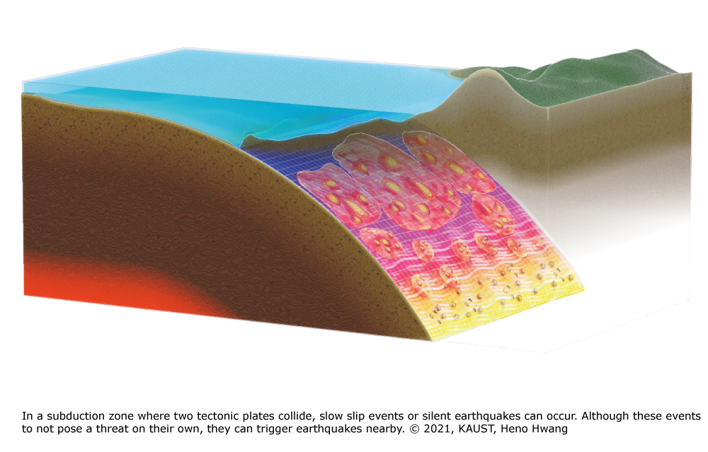
Earthquakes are caused by the sudden release of stress along faults in the Earth's crust. The resulting seismic waves of this fast ruptures of the Earth crust propagate through the ground, causing the shaking we perceive as earthquakes. But there are also more gentle processes, non-shaky versions of seismic fractures. These so-called "slow slips" attracted the attention of a research team from the Swiss Seismological Service at ETH Zürich, the King Abdullah University of Science and Technology (KAUST) in Saudi Arabia, the University of Geneva in Switzerland, the German Research Centre for Geoscience (GFZ) and the University of Bologna in Italy.
Slow slip events are fractures of the Earth's crust that propagate very slowly without generating considerable ground shaking. This fracture process can last from less than a day to more than a year. Yet, slow slips have the potential of triggering earthquakes or earthquakes swarms – a process that is not fully understood so far.
Read more...Slow slips are most common in regions where tectonic plates slide over each other (in subduction zones), especially all around the edge of the Pacific Ocean, including Japan, New Zealand, North and Central America or near volcanoes such as Mt. Etna in Italy or Kilauea in Hawaii.
The team analysed the correlation between the characteristics of each slow event and the triggered seismic activity. The results show that shallower slow slips are more likely to generate larger seismicity compared to deeper slow slip processes. This information can now be used to improve a model to predict the changes and hazards associated with these specific types of events. The researchers hope that the database and modelling can be developed further to build a better understanding of those complex processes.
The research was recently published in the scientific journal “Science Advances” and is accessible under the following link: https://advances.sciencemag.org/lookup/doi/10.1126/sciadv.abg9718
2021-07-07
[Available in DE / FR] Verspürtes Beben bei Eglisau
Ein Beben der Magnitude 2.0 ereignete sich am Mittwoch, 7. Juli 2021, um 10:25 Uhr (Ortszeit) bei Eglisau (ZH) in einer sehr geringen Tiefe, innerhalb der obersten Kilometer der Erde. Weil sich das Beben so nahe der Erdoberfläche ereignet hat, war es trotz seiner kleinen Magnitude in Eglisau deutlich zu verspüren. Dies belegen die ungefähr 50 Verspürtmeldungen, die in den ersten beiden Stunden nach dem Beben beim Schweizerischen Erdbebendienst (SED) an der ETH Zürich eingegangen sind. Auch typisch für solch schwache, untiefe Beben ist, dass sie teilweise als Knall und weniger als Bodenerschütterung wahrgenommen werden. Bei einem Erdbeben dieser Stärke sind keine Schäden zu erwarten.
Read more...Das Gebiet von Eglisau ist seit 1984 für seine seismische Aktivität bekannt, die durch sehr schwache und selten spürbare Beben in geringer Tiefe charakterisiert ist. Das letzte etwas stärkere Beben bei Eglisau, mit einer Magnitude von 3.1, ereignete sich am 12. September 1999. Das aktuelle Beben ist das stärkste Ereignis seit diesem Datum; in den Jahren 2004 und 2015 gab es jeweils ein Ereignis mit einer Magnitude von knapp 2. Die Charakterisierung der tektonischen Strukturen, die für diese Erdbeben verantwortlich sind, ist Gegenstand von laufenden wissenschaftlichen Untersuchungen.
2021-07-01
Earthquake near Furkapass
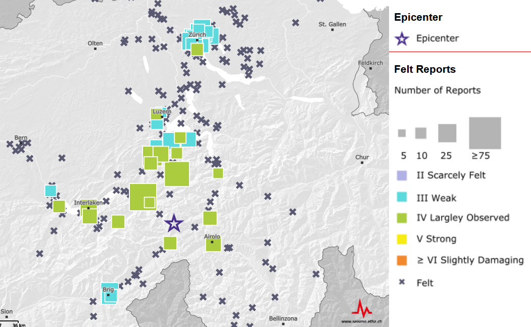
On Thursday, 1 July 2021 at 13:11 local time an earthquake with a magnitude of 4.0 has hit the region north of the Furkapass. The hypocenter was at a depth of about 7 km. The event was mostly felt in the north-south extent up to Zurich and Schaffhausen as evidenced by the more than 500 felt reports handed in up to now. We have received only few felt reports from Western Switzerland and the cantons of Grisons. No damage is reported up to now. Notable damage is not expected for an event of this magnitude, even less as its epicenter is in a scarcely populated region.
The area from the Valais over Central Switzerland to the Grisons is known for higher-than average earthquake activity. However, for the greater Furka region no damaging earthquakes are known for the past centuries.
2021-06-09
[Available in DE / FR] Erdbeben bei Neuenburg
Am Mittwoch, den 9. Juni 2021, ereignete sich um 10:30 Uhr (Ortszeit) ein Erdbeben der Magnitude 2.4 in Neuenburg. Das Epizentrum lag nördlich des Bahnhofs. Das Beben ereignete sich in einer für Erdbeben sehr geringen Tiefe, in den obersten 1-2 km der Erdkruste. Es wurde daher trotz der eher niedrigen Magnitude in Neuenburg von zahlreichen Personen deutlich verspürt. Im Jahr 2021 traten in der Umgebung von Neuenburg bereits mehrere solcher sehr flachen und deutlich verspürten Beben auf. Eines mit einer Magnitude von 2.9 ereignete sich im Februar und eines Ende Mai mit einer Magnitude von 2.6. Diese scheinbare Häufung der Beben in der Region ist unserer Einschätzung nach voraussichtlich ein statistischer Zufall. Tektonisch liegt die Region rund um den Neuenburgersee an der Grenze zwischen Molassebecken und Juragebirge, einer Region innerhalb der Schweiz mit einer mittleren Erdbebengefährdung. Beben dieser Magnitude sind somit zwar seltener als etwa im Wallis, aber nicht ungewöhnlich und auch stärkere bzw., Schadensbeben sind nicht auszuschliessen. Im Jahr 1876 gab es beispielsweise in der Region Neuenburg ein deutlich stärkeres Beben mit einer Magnitude 4.5.
![[Available in DE / FR] Erdbeben bei Neuenburg [Available in DE / FR] Erdbeben bei Neuenburg](/export/sites/sedsite/home/.galleries/img_news_2021/20210609_Neuchatel.png_2063069299.png)
2021-04-22
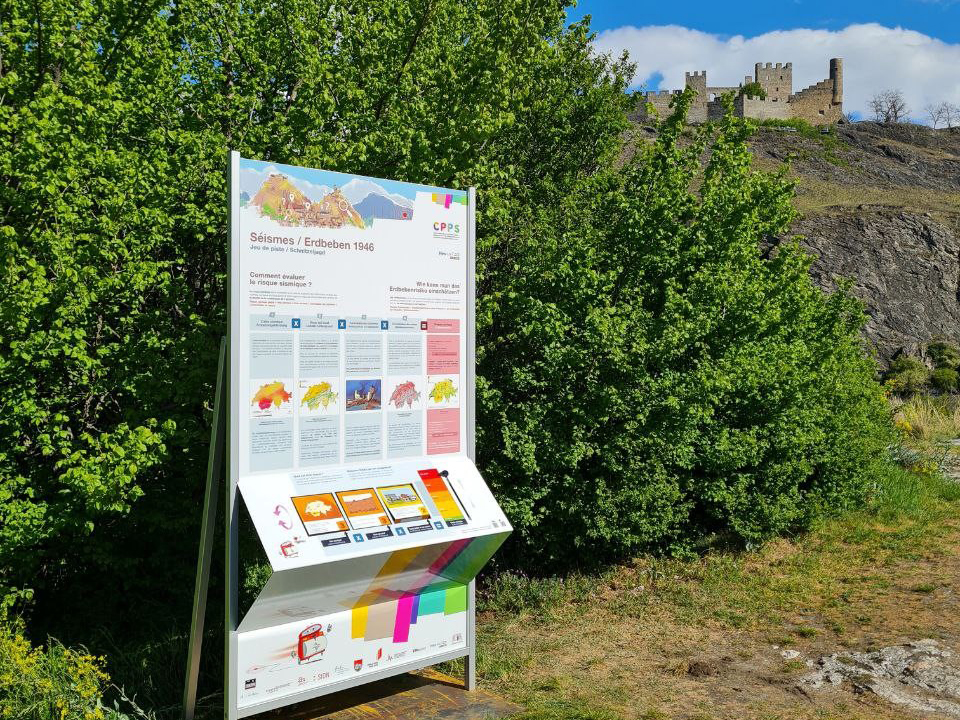
On the trail of the 1946 earthquake – an interactive treasure hunt through Sion
Today, 22 April 2021, sees the launch of an interactive treasure hunt focusing on the 1946 earthquake. At 13 stations dotted around Sion's Old Town, visitors will be invited to play a series of games to find out more about the events back then and what they mean for us today. They'll be led on the hunt by Wallis, the seismograph mascot of the Pedagogical Centre for Earthquake Prevention (CPPS) in the canton of Valais ('Wallis' is German for 'Valais').
All that people need to take part is a smartphone and the GuidiGO app, in which they can download the 'Earthquakes in 1946' tour. The treasure hunt is available in English, French and German and takes about two hours to complete.
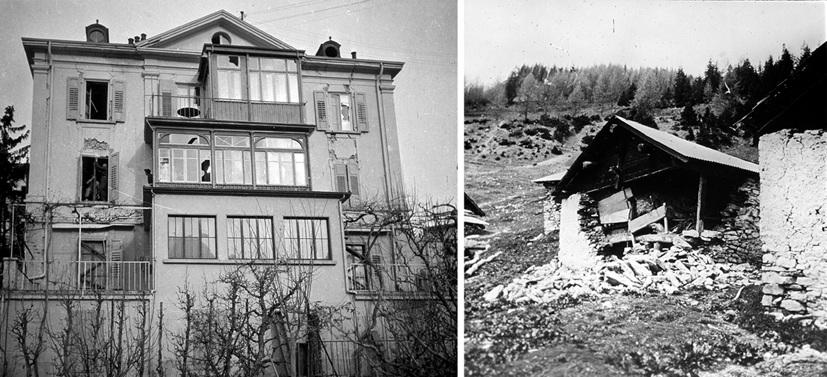
Why in Sion and why now? On 25 January 1946, the canton of Valais was hit by a magnitude 5.8 earthquake – the most recent earthquake in Switzerland to claim human lives. This year, 75 years on, a series of events is getting under way in Sion to commemorate the earthquake, highlight current scientific knowledge about the seismic hazard in Switzerland and raise public awareness of the risk. The treasure hunt was developed with the support of the Commune and Bourgeoisie (Citizens' Commune) of Sion, the Swiss Seismological Service (SED) at ETH Zurich and the HES-SO Valais-Wallis university of applied sciences.
We hope that everyone who takes part enjoys the tour!
For more information, visit: www.cpps-vs.ch/en-us/Earthquakes-1946
Background information about the 1946 earthquake can be found here.
2021-04-06
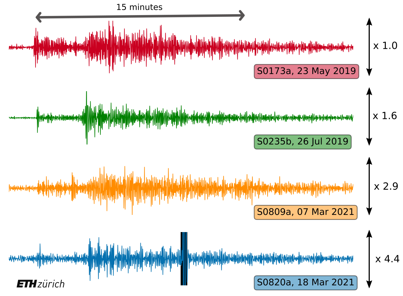
After the storms: InSight detects large marsquakes
NASA’s InSight mission detected two large marsquakes as summer emerges, the winds calm, and the dust settles. Now, after one Martian year (687 Earth days) the Marsquake Service led by ETH Zurich and operated by the Seismology and Geodynamics group and the Swiss Seismological Service is faster than ever at characterizing seismic activity on the red planet.
After several months of windy weather and dust storms, the atmosphere of Mars is becoming quiet again and the seismometer on the InSight lander started recording significant marsquakes. In early March, two new marsquakes with magnitudes of 3.3 and 3.1 were observed. Within 12 hours of the data arriving on Earth, researchers at the Marsquake Service at ETH Zurich determined the location, magnitude and, in one case, even the focal mechanism. This rapid result demonstrates that the whole chain of data recording, transmission, and analysis set-up by the InSight mission is functioning efficiently and rapidly. These moderately sized events recorded at over 1,200 km distance and by a single station (that would not even be observed by a similar station on Earth), are sufficient to confirm the emerging geological interpretation of the internal structure and surface tectonics of the red planet acquired over the past year on Mars.
Read more...Since the beginning of the Mars InSight mission on 26 November 2018, over 500 marsquakes have been recorded. With magnitudes between 1 and 4, these are small events compared to terrestrial earthquakes. Only a few of these marsquakes could be reliably located, determining both the direction and distance from the seismometer. The recently detected, larger marsquakes are located in Cerberus Fossae, a long graben system about 1,200 km from Elysium Planitia, where InSight landed. They have an extensional mechanism consistent with the regional tectonic setting showing that the Martian crust is still undergoing active deformation.
In the InSight mission, data recorded on Mars are relayed back to Earth in regular transmissions, often multiple times a day, via the NASA Deep Space Network. They are promptly compiled and controlled for quality by the Jet-Propulsion Laboratory (JPL) in the U.S. and the National Centre for Space Studies (CNES) in France, and delivered to the Marsquake Service located at ETH Zurich in Switzerland. The Marsquake Service is responsible for the first analysis of the Mars data, with the goal of identifying marsquakes and releasing periodic marsquake catalogues – the starting point for further scientific investigations. This is a collaborative ground service operation that includes on-duty seismologists from ETH Zurich, Institut de physique du globe de Paris (IPGP), University of Bristol, and Imperial College London. At the start of the mission, the data recorded on Mars was full of surprises and difficult to decipher. After a full year of processing seismic data from Mars, the Marsquake Service is now able to fully characterise the signals within just a few hours after having been recorded on Mars. This performance is comparable to that achieved by modern seismic networks on the Earth.
Recognizing the successful performance of InSight, NASA has approved the extension of the mission for a second Martian year. Unfortunately, the red dust which characterises all the pictures of Mars is also accumulating on InSight’s solar panels, reducing the panel’s power production and raising concerns about the long-term operation of the mission.
To learn more about the NASA InSight mission visit www.insight.ethz.ch or https://mars.nasa.gov/insight/
2021-03-19
MLhc: a revised local magnitude for Switzerland
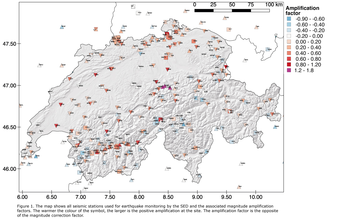
One of the most common ways to characterise an earthquake is by its magnitude, which quantifies the energy released during an earthquake, i.e. its strength. The larger the earthquake's magnitude, the more likely it becomes to feel the shaking. There are different types of magnitudes: for example, the local magnitude (ML, the Richter scale, for earthquakes recorded close-by), the body wave magnitude (mb, for earthquakes at large distances), the surface wave magnitude (MS, also for large distances) or the moment magnitude (Mw, for all earthquakes types). These different scales have been developed and modified over the last century, reflecting mainly our improving capability to monitor earthquakes of different sizes and at different distances. Common to all magnitude types is the fact that they can be calculated directly from the earthquake signals recorded by seismic stations. In order to better characterise earthquakes in Switzerland, the Swiss Seismological Service at the ETH Zurich (SED) has recently introduced a revised local magnitude (MLhc).
Read more...MLhc makes the routine computation of local magnitudes in Switzerland entirely consistent with the state-of-the-art of engineering seismology research at the SED, and allows optimal use of the high-density Swiss National Seismic Network. What does this mean exactly, and how does MLhc differ from the previous local magnitude we used?
Earthquakes are commonly characterised using the local magnitude (ML), originally introduced by Charles Richter in California in 1935. ML is often found to be region dependent. In 1984, Urs Kradolfer, a former scientist at SED, calibrated ML for Swiss earthquakes. His calculations were based on the recordings of the Swiss National Seismic Network, which comprised 23 stations at that time that recorded vertical ground motions only. At the turn of the century, Kradolfer’s model was later amended to take advantage of the next generation of 3-component digital broadband instruments in the upgraded Swiss National Seismic, in particular by using horizontal ground motion records (MLh).
In the last 20 years, the Swiss National Seismic network has grown significantly and now comprises more than 200 seismic stations, including over 100 high-quality strong-motion sensors. The SED is now routinely recording earthquakes at very close distances (15 to 20 km) to their focus in the ground (hypocenter), often with MLh much smaller than 2. Such close distances and small magnitudes are outside the calibration range of Kradolfer’s model. Another limitation of MLh is that station correction factors due to local soil conditions were not systematically used. However, this is crucial, particularly at strong-motion sites mostly installed in urban areas and often characterised by significant amplification of ground motions. When using MLh, seismologists had to reject station magnitudes from sites too close to the earthquake or with strong site amplifications. To cope with these drawbacks, the SED recently migrated to a revised local magnitude: "MLhc". The “c” stands for "corrected".
In summary, by design MLhc has been calibrated to provide magnitudes that are as similar as possible to MLh, yet with two considerable improvements that allow seismologists to use all stations collected in the network and provide more stable magnitudes, especially for small earthquakes:
- First, it is calibrated using a much larger dataset including many records from very close to the hypocentre. Therefore, MLhc allows us to include stations at distances closer than 20 km from the hypocenter.
- Second, the procedure to compute MLhc accounts for physics-based site amplification factors that are routinely calculated and updated by the SED, allowing us to use all stations regardless of site effects.
While for a simpler communication, the SED only uses the term "magnitude", the detailed information provided on the SED website always specify the earthquake magnitude type.
More information on the different magnitude types can be found here.
2021-03-15
[Available in DE/FR] Erdbeben bei Bern
Am Montag, dem 15. März 2021 hat sich um 14:27 Uhr (Lokalzeit) südlich von Bern in einer geringen Tiefe von rund 5 km ein Erdbeben der Magnitude 3.2 ereignet.
Die Erschütterungen waren vorwiegend im Grossraum Bern gut zu spüren. In der ersten Stunde nach dem Beben sind beim Erdbebendienst bereits mehrere Hundert Meldungen aus der Bevölkerung eingegangen. Bei einem Erdbeben dieser Stärke sind keine Schäden zu erwarten.
Am 3. Februar 2021 ereignete sich ungefähr 10 km nördlich des aktuellen Ereignisses ein kleineres Beben mit Magnitude 2.8, das in einem ähnlichen Gebiet verspürt wurde. Auch in der näheren Umgebung zum Erdbeben vom 15. März 2021 wurden bereits kleinere Erdbeben registriert, ein spürbares zuletzt am 6. Juni 2015 mit Magnitude 2.6. Zudem wird derzeit ein möglicher Zusammenhang mit einer Nord-Süd verlaufenden Struktur von Erdbeben südlich von Bern analysiert.
2021-02-07
[Available in DE/FR] Erdbeben bei Cornaux (NE)
Am Sonntag, dem 7. Februar 2021, ereignete sich um 10:37 Uhr (Ortszeit) nördlich von Cornaux in sehr geringer Tiefe ein Erdbeben der Stärke 2.9.
Die Erschütterungen waren in einem Radius von 5 km um das Epizentrum gut zu spüren, insbesondere in Cornaux, Cressier und Marin-Epagnier. Die sehr geringe Tiefe des Ereignisses erklärt, warum es in der Umgebung deutlich zu spüren war, aber keine Meldungen aus einer Entfernung von mehr als 6 km beim Schweizerischen Erdbebendienst an der ETH Zürich eingegangen sind. Bei einem Erdbeben dieser Stärke sind keine Schäden zu erwarten.
Das letzte von der Bevölkerung in dieser Region verspürte Erdbeben ereignete sich am 3. Februar 2003, sein Epizentrum lag 3 km südwestlich des heutigen Bebens.
2021-02-05
[Available in DE, FR] Beben bei Singen (D)
Ein Beben der Stärke 3.2 ereignete sich am Freitag, 5. Februar um 15:14 Uhr (Ortszeit), südwestlich von Singen (D), ca. 15 km nordöstlich von Schaffhausen, in einer Tiefe von rund 10 km. Bei einem Erdbeben dieser Stärke sind keine Schäden zu erwarten. Dem Erdbeben gingen seit Freitagmorgen sieben kleinere Vorbeben mit Magnituden zwischen 1.1 und 2.0 voran, zudem ereigneten sich einige Nachbeben, das stärkste bisher mit einer Magnitude von 2.0. Das Beben wurde im Grenzgebiet vereinzelt, schwach verspürt.
Das Gebiet war bereits 2016 seismisch aktiv, mit einer Sequenz von über 100 vornehmlich sehr schwachen Beben bei Hilzingen (D), von denen das stärkste eine Magnitude von 3.0 aufwies. Die Beben von heute liegen ca. 3 km weiter südöstlich, in der Verlängerung der damals, nach eingehender Analyse, identifizierten Störungszone.
Read more...Die Orientierung dieser Störungszone stimmt gut mit dem Verlauf des Hegau-Bodensee Grabens überein. Dieser ist Teil einer grossräumigen tektonischen Grabenstruktur, die sich vom Kaiserstuhl nordwestlich von Freiburg (D) bis zum Bodensee erstreckt, und durch die tertiären und mesozoischen Sedimente vermutlich bis hinab ins Grundgebirge reicht. Die jetzige Sequenz kann vermutlich als weiterer Ausdruck der tektonischen Deformation entlang dieser Grabenstruktur gedeutet werden. Um das zu bestätigen, sind allerdings noch vertiefte Analysen notwendig.
2021-02-03
[Available in DE/FR] Erdbeben bei Bern
Am Mittwoch, dem 3. Februar 2021 hat sich um 23:35 Uhr (Lokalzeit) nördlich von Bern, in einer geringen Tiefe ein Erdbeben der Magnitude 2.8 ereignet.
Die Erschütterungen waren vorwiegend in Bern und im Gebiet um Bern, in Liebefeld, Ittigen und Zollikofen gut zu spüren. Bis kurz nach Mitternacht sind beim Erdbebendienst bereits über 200 Meldungen aus der Bevölkerung eingegangen. Bei einem Erdbeben dieser Stärke sind keine Schäden zu erwarten.
Bereits knapp eine Stunde vor diesem Beben, um 22:37 Uhr und 22:39 Uhr, wurden vom Schweizerischen Erdbebendienst an der ETH Zürich zwei Vorbeben an ähnlicher Stelle und Tiefe mit geringeren Magnituden um 2 registriert. Diese zwei schwächeren Beben wurden in Bern und der unmittelbaren Umgebung nur ganz vereinzelt verspürt.
2021-01-25
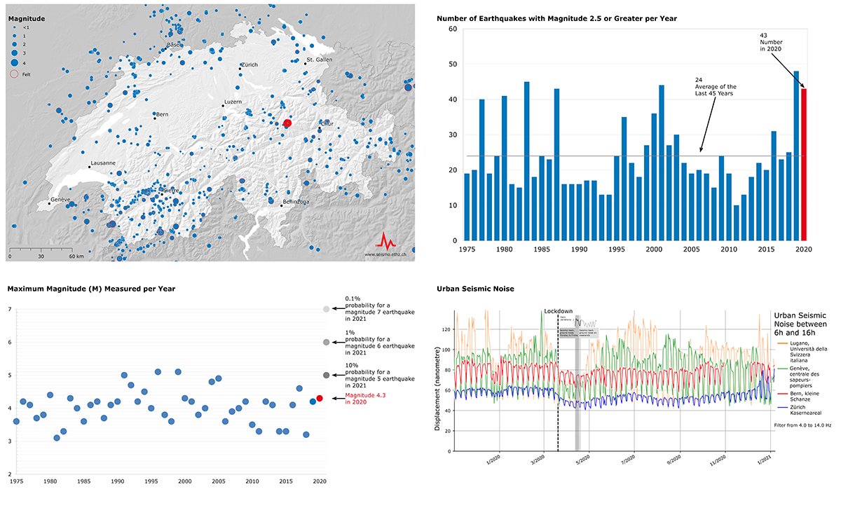
Earthquakes in Switzerland in 2020
2020 was a busy and yet also a quiet year for Switzerland's seismic network. Last year, the Swiss Seismological Service at ETH Zurich recorded 1,400 earthquakes in Switzerland and its neighbouring countries. This is slightly more than would have been expected based on the long-term average. 'Felt reports' (i.e. reports of having felt an earthquake) from members of the public were received for 106 of these quakes, with over 100 people submitting their observations about seven of them. At the same time, though, the levels of background noise logged by the seismic network were exceptionally low in 2020. The recorded data show that these fell sharply in many locations, especially during lockdown.
The largest earthquake and most of the felt quakes formed part of an earthquake sequence near Elm (in the canton of Glarus), which was particularly active in both spring and autumn. An initial relatively strong earthquake, with a magnitude of 3.1, shook Glarus on 26 May 2020, and was followed by dozens of smaller aftershocks. On 25 October, the same fault system saw Switzerland's largest earthquake of the year with a magnitude of 4.3, which was felt as far away as Ticino and Lake Constance. No significant damage was recorded. Again, this was followed by more than 250 aftershocks, some of which could also be felt over a wide area, with magnitudes of up to 3.9. In total, there were over 350 earthquakes in this sequence. Largely because of these events, 2020 was an above-average year in terms of the number of quakes.
Read more...While the Elm sequence mainly affected German-speaking Switzerland, on 23 June an earthquake with a magnitude of 3.8 near Vallorcine in France prompted a lot of felt reports from French-speaking western Switzerland. Meanwhile, residents of Italian-speaking Ticino experienced a quake with a magnitude of 3.9 that had its epicentre near Milan in Italy, and another of 2.9, close to Bellinzona (in the canton of Ticino itself). Another relatively strong quake with a magnitude of 3.5 occurred on 9 November to the south of Arolla (canton of Valais) in the Swiss-Italian border region. The fact that relatively strong earthquakes can be felt far from their epicentre was shown by a magnitude-6.3 quake in Croatia, which caused significant damage in the area of its epicentre. In Switzerland, around 600 kilometres away, more than 30 people noticed and reported tremors associated with this event. Most of them were on the upper floors of relatively tall buildings at the time of the quake. For earthquakes such a long distance away, Switzerland mainly feels the long-period waves, which can rock high-rise buildings in particular.
When the more than 200 seismic stations in Switzerland are not recording the waves of an earthquake, they are measuring what is known as 'background noise'. As well as natural vibrations, triggered by storms or movements of the sea, this noise is mainly influenced by human activity such as traffic. Only general movement patterns can be detected with seismometers and not, for example, the movements of individual people or vehicles. The lockdown in March and other measures to contain the coronavirus led to a marked decrease in this background noise. This was the longest ever recorded period of lower levels of such noise. Normally, such lulls are only seen at weekends or on public holidays.
Looking at the trend for daily background noise shown above at four locations, we can see a clear decrease in each case as a result of the lockdown introduced in Switzerland on 16 March 2020. At the end of this unprecedented situation in mid-June, there is a resurgence in the levels of such noise. The background noise recorded by seismometers is unique at each station and depends, for example, on how far away certain sources of noise are. At Kleine Schanze in Bern and Zurich's Kasernenareal, the decline as a result of the lockdown is less pronounced than elsewhere. This has to do with the fact that both of these sites are further away from busy roads than others. The smaller, recurring fluctuations that can be seen at all locations reflect differences between weekdays and weekends. This means that, even during the lockdown, background noise at the weekend was lower than from Monday to Friday.
2021-01-25
75 years since Switzerland's last major earthquake
It was already dark on 25 January 1946 when a violent earthquake with a magnitude of 5.8 shook Valais. Four people were killed, many were injured and 3,500 buildings were damaged, some of them severely. It took some time for the full extent of the quake to become clear. This was not only to do with the time at which the earthquake struck, but also with the scale of the damage and the options available at the time for evaluating seismic data. As well as causing damage to buildings, much of which only became apparent in daylight, the earthquake triggered avalanches and rockslides. In addition, the data from the few seismographs in Switzerland had to be read and analysed manually. Collecting 'felt reports' and damage reports was just as laborious, and such reports were more important back then due to the small number of instrumental records. This was the biggest Swiss earthquake in the past 150 years and the last one to claim lives. Could such an earthquake happen again and what would its impact be today?
Read more...A comparable earthquake can be expected to hit Switzerland every 50 to 150 years, but earthquakes do not follow a precise timetable. The next big quake could equally happen very soon or in a few decades' time. Along with the Basel region, Grisons, Central Switzerland and the St. Gallen Rhine Valley, Valais is one of the areas with the highest seismic-hazard levels in the country. Although major earthquakes can theoretically occur throughout Switzerland, the number of earthquakes in these regions is greater, meaning that powerful earthquakes are also more frequent there. If an earthquake similar to that of 75 years ago were to strike the Rhone Valley today, the impact would be much greater, probably causing around CHF 26 million of damage, as the area is more densely populated.
Perceptible tremors regularly remind the people of Valais that the ground beneath their feet is seismically active. In addition to individual quakes, earthquake sequences often occur in Valais, as elsewhere in Switzerland. A particularly active sequence, with over 16 felt quakes in 10 days, was observed near the Sanetsch Pass in 2019. The 56 seismic stations in Valais also record many smaller earthquakes. This dense monitoring makes it possible to track seismic activity around the clock and to inform the population, authorities and the media immediately in the event of major tremors or quakes. The analysis of seismic data also helps us to better understand the local subsurface and is therefore instrumental in ensuring earthquake preparedness. In addition to knowledge about recommended behaviour, earthquake-resistant construction is particularly crucial for mitigating the impacts of an earthquake. The canton of Valais has invested heavily in both these areas in recent years.
Earthquake activity in Valais, and throughout Switzerland, is linked to collisions between the European and African lithospheric plates. These generate numerous fault systems in the subsurface, where tension builds up and is then suddenly released in the form of earthquakes. From a geological point of view, the Rhone-Simplon line, running in the Sion area along the northern edge of the Rhone Valley, is one of the main fault zones in the region. The seismicity around the Helvetic nappes north of the Rhone Valley is therefore probably related to the deformation processes along the Rhone-Simplon fault line, but possibly also to the deeper uplift processes in the area of the Aar massif and the Aiguilles Rouges/Mont Blanc massif. Research being conducted by the Swiss Seismological Service (SED) at ETH Zurich aims to improve our understanding of these tectonic processes and their effects on current seismicity. The SED is also developing an earthquake risk model for Switzerland together with the Federal Office for the Environment, the Federal Office for Civil Protection and EPFL. In the future, this will help to better assess the possible impacts of an earthquake and verify the cost-effectiveness of prevention measures.
![[Available in DE/FR] Zwei spürbare Erdbeben im Wallis und im französischen Jura [Available in DE/FR] Zwei spürbare Erdbeben im Wallis und im französischen Jura](/export/sites/sedsite/home/.galleries/img_news_2021/20211102_kombi-beben-wallis-jura_1200px.png_2063069299.png)
![[Available in DE / FR] Erdbeben bei Arolla (VS) [Available in DE / FR] Erdbeben bei Arolla (VS)](/export/sites/sedsite/home/.galleries/img_news_2021/arolla_20210510.png_2063069299.png)
![[Available in DE / FR] Verspürtes Beben bei Eglisau [Available in DE / FR] Verspürtes Beben bei Eglisau](/export/sites/sedsite/home/.galleries/img_news_2021/20210707_Epicenter_Eglisau.JPG_2063069299.jpg)
![[Available in DE/FR] Erdbeben bei Bern [Available in DE/FR] Erdbeben bei Bern](/export/sites/sedsite/home/.galleries/img_news_2021/20210315_Bern_de_v2.PNG_2063069299.png)
![[Available in DE/FR] Erdbeben bei Cornaux (NE) [Available in DE/FR] Erdbeben bei Cornaux (NE)](/export/sites/sedsite/home/.galleries/img_news_2021/20210207_Cornaux_Bild1.PNG_2063069299.png)
![[Available in DE, FR] Beben bei Singen (D) [Available in DE, FR] Beben bei Singen (D)](/export/sites/sedsite/home/.galleries/img_news_2021/20210205_Erdbeben_Singen.png_2063069299.png)
![[Available in DE/FR] Erdbeben bei Bern [Available in DE/FR] Erdbeben bei Bern](/export/sites/sedsite/home/.galleries/img_news_2021/Bern_deutsch.png_2063069299.png)
