In Europe
Earthquakes in Europe are essentially a result of stress in the earth’s crust. For naturally occurring earthquakes, the source of this stress is plate tectonics. The Eurasian plate encompasses much of Europe’s and Asia’s mainland, and moves with respect to the main neighbouring plates in the South (African plate), Southeast (Anatolian microplate), and West (North-America plate). In addition, there are a number of microplates between Europe and Africa. These make the tectonic picture particularly complex around the Mediterranean Sea including the Alpine region. Because of the microplates, earthquakes in Europe occur across a large area, not only along a well-defined zone.
Below we list and briefly describe the six main earthquake zones and their reasons in Europe.
This major plate with the most important effect on today’s earthquake picture collided with Europe about 65 million years ago. As mentioned above, several smaller plates and ocean basins between the two plates have caused a very complex pattern of seismicity all around the Mediterranean. Today Europe and Africa are in direct contact in Southern Greece, where Africa goes below Europe (subduction). To the north of this active subduction zone is the Corint Rift which is opening in a North-South direction. Greece is the country in Europe with the highest seismic hazard.
East of the Africa-Europe subduction zone is the Anatolian microplate, broadly occupying the area of Turkey. Its northern edge along Europe is known as the North-Anatolian Fault, along which several large earthquakes have happened throughout the 20th century (Magnitude larger than 7). A particularity is that these earthquakes in the past have happened progressively from East to West, approaching Istanbul.
Europe’s western neighbour is the North-American plate, regularly causing moderate size earthquakes at the bottom of the sea. The situation is more interesting in Iceland, where a hot spot on the plate boundary is creating an island and a complex zone of both tectonic and volcanic events. Iceland is not the only place where volcanic activity is present in Europe: Mount Etna and Mount Vesuvius are prime examples of this phenomenon.
West of the Africa-Europe subduction zone is the Adria microplate, broadly occupying the area of Italy. This plate was previously a piece of Africa, and it has been pushed by Africa into Europe, causing the rise of the entire Alps. A well-known piece of Adria is the summit of Matterhorn. The Alps are a short but very complex mountain range, with a broadly distributed earthquake activity in Italy, France, Switzerland, Germany, Austria and Slovenia. The largest known Alpine event is a historical earthquake in 1348 with a Magnitude of 7, located on the border between Italy and Austria, near Villach. The well-known Basel earthquake of 1356 (Magnitude 6.6) is particular because it is located at the junction of the Alpine realm and the Rhine Graben. The country related to the Adria plate with the highest hazard is Italy, not because of the Alps but because of the Appenines spanning all along the peninsula.
East of the Alps is a region with several small microplates and mountain ranges: The Pannonian Basin (today’s Hungary and neighbouring countries), the Carpathians to its North and East (Slovakia, Ukraine, Romania) and the Dinarides to its South (most of the Balkan Peninsula, all countries from Slovenia to Greece and Turkey). The movement of these plates has slowed down and the mountain ranges are moderately active today, except for the Southeastern corner of the Carpathians. This is known as the Vrancea zone, in Romania, where the last piece of lithosphere, which has not had place on the surface, is sinking to depth. In the 20th century there were four large earthquakes (Magnitude larger than 7) there, the latest in 1977. These put the city of Bucharest at risk and may cause tsunami on the Black Sea.
At the western end of the Mediterranean Sea is the Iberia microplate, broadly occupying the area of Spain and Portugal. This plate has also collided with Europe, causing the rise of the Pyrenees. Current earthquake activity is in the Pyrenees and in the southern edge of the Iberia microplate, near Africa. The well-known tsunami, which hit Lisbon in 1755, was likely an earthquake offshore Europe in the Atlantic Ocean.
Like in other parts of the world, earthquakes in Europe also occur in regions that are far from today’s tectonic boundaries, such as in Germany, the Czech Republic and United Kingdom. These events are primarily caused by remnant stresses from the geologic history. Some of them can be associated to moving fluids in the Earth’s crust, either naturally or artificially (see geothermal projects / fracking page).
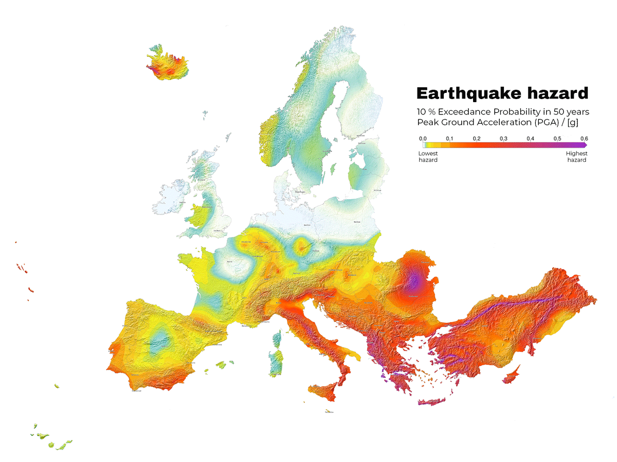
Scientists produce seismic hazard maps based on computations on the probability of earthquakes happening in different areas of Europe. These maps must be regularly updated based on new methods that reflect the latest earthquake catalogues and recorded data. The current map highlights how seismic hazard should be an important consideration in the everyday life of many Europeans.
Earthquake Hazard Map of Europe (Danciu et al. 2021)
