In Switzerland
The Alps are the result of a complex geological history involving two large lithospheric plates: Europe and Africa. The lithosphere is the outermost solid shell of the Earth. It is about 100 km thick and consists of two layers, the crust on top and the mantle lithosphere below. The global lithosphere is fractured into numerous large and small plates that move in different directions on the viscous mantle, rubbing against or colliding with one another. The entity of all of these processes is called plate tectonics.
Due to their composition, we differentiate between two types of lithosphere: continental and oceanic. The oceanic lithosphere is denser than the viscous mantle below it and can therefore sink. The continental lithosphere is less dense than the mantle and therefore remains floating on top of it. When oceanic lithosphere meets continental lithosphere during the collision of two plates, the oceanic lithosphere dives into the viscous mantle below it – a process that is called subduction and that is usually associated with large earthquakes and volcanic activity. If two continental lithosphere plates collide, a mountain range develops along the plate boundary.
Not only the European and African plates participated in the formation of the Alps, but also several smaller lithospheric plates, which are known as micro plates. Particularly important is the Adriatic micro plate. Following the complete subduction of the oceanic lithosphere, and thus the closing of the original ocean (called Alpine Tethys by scientists) between Europe and Africa about 35 million years ago, the continental parts of the European and the Adriatic/African plates collided, initiating the formation of the Alps. Similarly to a floating iceberg, the weight of the mountains is supported by the buoyancy of a large crustal root. With increasing height of the mountains, erosion of rocks at the Earth’s surface plays an ever more important role. With the removal of rock material at the surface the weight of the mountains decreases and the crust beneath the Alps rises again to retain the isostatic equilibrium. The massive erosional debries of the mountains has accumulated on both sides of the Alps over the last 30 million years: as the Molasse sediments in the north and as sediments filling the basin beneath the Po plain in the south. The Alps as we know them today have thus been shaped by forces from the Earth’s interior and by erosion. Today, the Alps are rising by approximately 1 millimeter per year and are simultaneously eroding.
Generally speaking, the earthquakes that we observe in Switzerland are the results of the collision between the European and the African lithospheric plates as they reflect the underlying mechanics of these processes. Seismic waves penetrate the subsurfaces thus illuminating the deep parts of the lithosphere beneath the Alps. One important detail has been discovered in the last few years: after the complete subduction of the oceanic lithosphere and the subsequent collision of the two continents, a piece of the original mantle lithosphere is still attached to the European plate (known as the mantle slab). This slab is bending the lithosphere in the northern foothills of the Alps downward, thus indirectly causing the widely distributed seismicity on the Swiss plateau. Since plate tectonic processes take place over geological time scales, it can be assumed that the current seismicity in the region of the Alps will remain the same for millions of years to come.
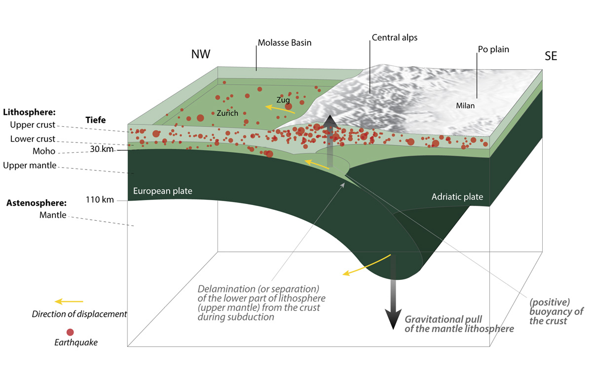
The hanging European slab (mantle lithosphere) causes a downward force, while the lower crust detaches from the slab and the large crustal root generates buoyancy to compensate for loads by topography (mountains) and by the slab (Singer et al. 2014, EPSL).
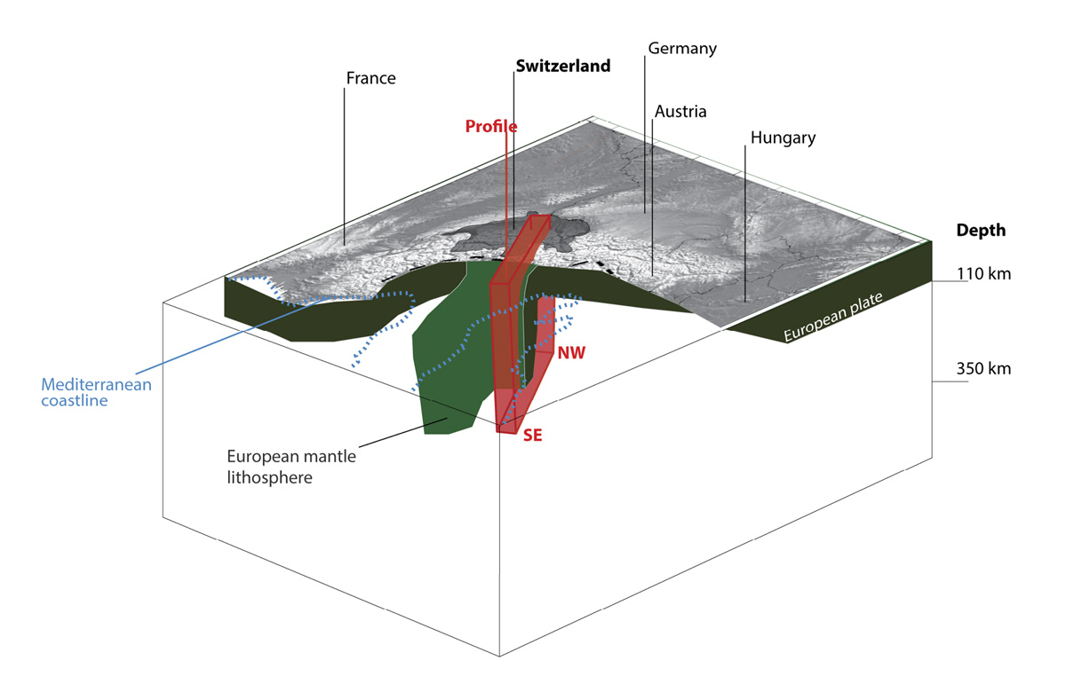
This is one of the main driving forces for earthquake activity in the Alps. The NW-SE profile that is marked in red is shown in the previous figure (Singer et al. 2014, EPSL).
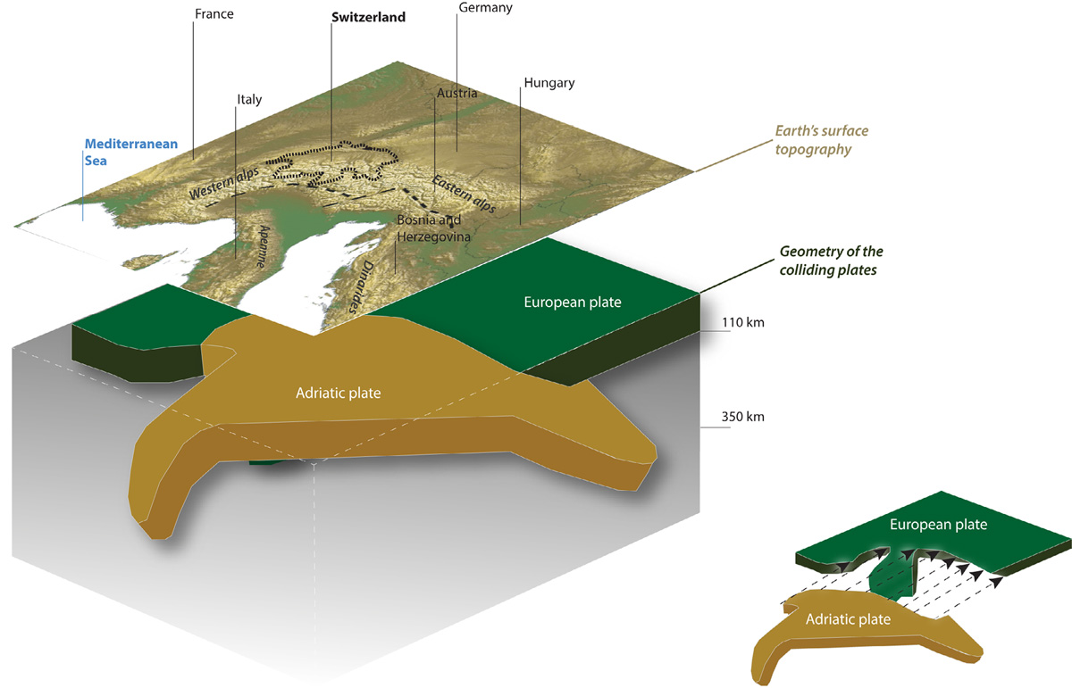
This is the other main driving force of Alpine seismicity. The geometry of the Adriatic plate is complex: in both the west and the east, it bends downward, opposite to the likewise bending European slab. Its southern end also bends downward. How the Adriatic plate overlaps Europe is shown on the bottom right (simplified from Lippitsch et al. 2003, JGR).
Seismic activity in Switzerland and the formation of the Alps are closely linked. Generally speaking, the earthquakes we observe in Switzerland result from collisions between the European and African lithospheric plates, reflecting the underlying mechanics of these tectonic processes.
Seismic waves penetrate the subsurface, casting light on the nature of the deep lithosphere beneath the Alps. One important detail has been discovered in the last few years: following the complete subduction of the oceanic lithosphere and the subsequent collision of the two continents, a remnant of the original mantle lithosphere (known as the mantle slab) remains attached to the European Plate. In the northern foothills of the Alps, this slab is bending the lithosphere downwards, thereby indirectly causing widely distributed seismicity on the Swiss plateau. Since plate tectonic processes take place over geological time scales, it can be assumed that the current level of seismicity in the Alpine region will continue for millions of years to come.
For background information on individual regions of Switzerland, see "Regional Earthquakes".
Human activity like tunnel construction, filling reservoirs and implementing geothermal or fracking projects can trigger earthquakes, too (see the page "Induced Earthquakes").
The Swiss Seismological Service (SED) has been operating a digital network of seismic stations since 1975. The majority of the recorded earthquakes take place in the Swiss Alps, especially in Valais and Grisons. Seismic activity is also particularly high in the northern foothills of the Alps, in Central Switzerland, and in the Jura and Basel regions.
Earthquakes occur at markedly different depths within the Alps and in the region north of it. Earthquakes in the northern foothills and the Jura occur throughout the entire crust of the Earth down to the Moho, the boundary between the crust and the mantle, outside the Alps at a depth of about 30 km. On the other hand, seismic activity underneath the Alps is limited to the upper part of the crust; here, quakes occur to depths of 20 km only while the Moho reaches a depth of more than 50 kilometers.

Valais and Grisons are regions in the Swiss Alps that have increased seismicity. The size of the circles indicates the local magnitude (ML) of the earthquakes. The thick black line shows the location of the deep cross section through Eastern Switzerland (see figure 2). Only quakes within the gray rectangle were used for the profile in figure 2.
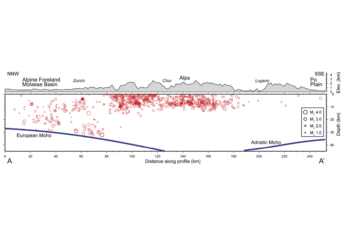
In the Alps, the occurrence of earthquakes is restricted to the upper crust; below the northern foothills and the Swiss plateau, earthquakes take place throughout the entire crust. The crust/mantle boundary is marked by Moho (see text). The size of the circles indicates the local magnitude (ML) of the earthquakes. The location of the profile is shown in Figure 1 (modified and updated from Deichmann et al. 1999, Eclogae).
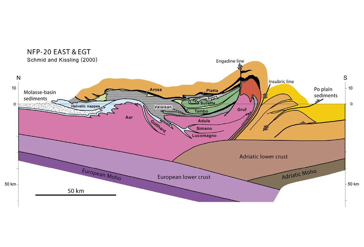
The European (from the left) and the Adriatic plates (from the right) collided, forming the Alps as we know them today (modified and updated from Schmid and Kissling 2000, Tectonics).
As a result of plate collision, strong earthquakes have occurred in the Alps and their surroundings time and time again in the past. Information from historical sources and modern earthquake catalogs show that there were at least 12 earthquakes with a magnitude of 6 or more in the past thousand years. The last major earthquake took place in 1976 in northern Italy (M6.5) followed by two aftershocks with magnitudes greater than 6 within a few months. This Friuli quake claimed 989 lives and injured 2,400 people; about 45,000 were left homeless as a result. Although the extent of damage for historical events can sometimes be difficult to estimate, it is likely that at least three of the quakes listed in the table caused more than 10,000 deaths.
Earthquakes cannot be predicted. As the time series shows, they also occur at irregular intervals. Therefore, we do not know where and when the next major quake will occur. A quake with a magnitude of 6 or more usually occurs every 50 to 150 years; quakes with a magnitude of 7 occur about 10 times less often.
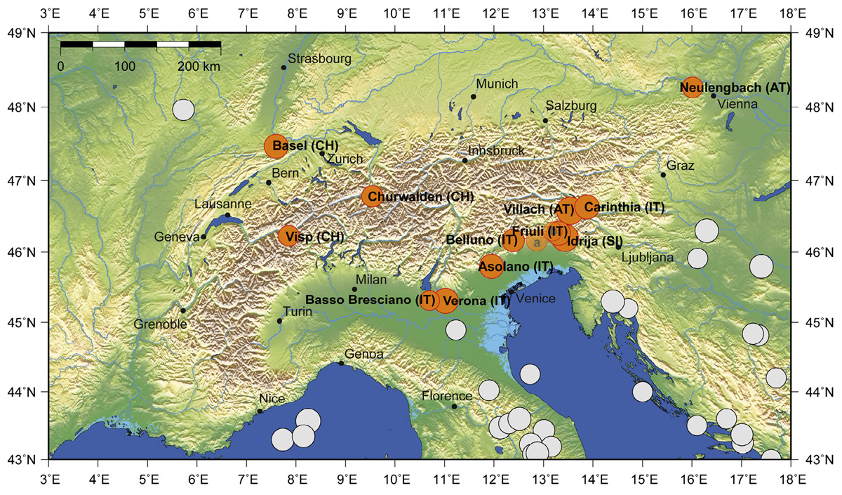
The orange circles indicate the quakes in the Alps and on the Swiss plateau listed in the table. The size of the circles is proportional to the magnitude. The gray circles mark quakes outside the region of the Alps. The aftershocks of the Friuli quake of 1976 are labeled 'a' and 'b'.
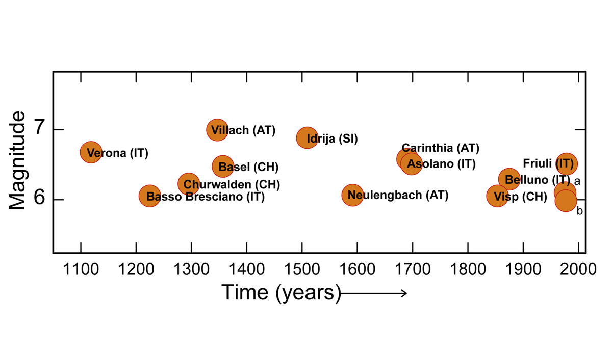
The aftershocks of the Friuli quake of 1976 are labeled 'a' and 'b'.
List of the largest earthquakes in the last millennium in the Alpine region
| Date | Location | Magnitudesource |
| 03.01.1117 | Verona (IT) | 6.7a |
| 25.12.1222 | Basso Bresciano (IT) | 6.0a, 6.1b |
| 03.09.1295 | Churwalden (CH) | 6.2a, b |
| 25.01.1348 | Villach (AT) | 7.0a |
| 18.10.1356 | Basel (CH) | 6.5a, 6.6b |
| 26.03.1511 | Idrija (SI) | 6.9a |
| 15.09.1590 | Neulengbach (AT) | 6.1a |
| 04.12.1690 | Carinthia (AT) | 6.6a |
| 25.02.1695 | Asolano (IT) | 6.5a |
| 25.07.1855 | Visp (CH) | 6.1a, 6.2b |
| 29.06.1873 | Belluno (IT) | 6.3a |
| 06.05.1976 | Friuli (IT) | 6.5c, d |