Ongoing Projects
This page provides details of selected ongoing projects managed by or prominently featuring staff from the Swiss Seismological Service (SED). The list is not exhaustive; it merely covers selected key or large-scale projects. The projects are grouped together according to the main focus of their research.
Cross-disciplinary projects
Seismo@School
|
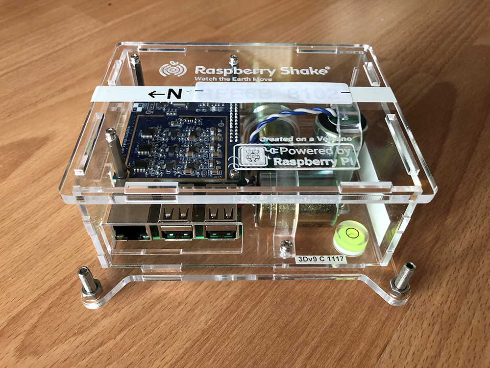
This project is based on the seismo@school program, which was initiated by the University of Lausanne and the HES-SO Valais-Wallis in recent years and in which 22 schools in the cantons of Valais and Vaud have so far participated. Thanks to a two-year AGORA project funded by the SNSF entitled "Promoting earthquake awareness in Switzerland", we will extend this program to the whole of Switzerland. In this project, in collaboration with the STEM Center at ETH Zurich, we will develop teaching materials and activities for secondary schools (ages 12-18) that will allow students to explore earthquake-related topics from current research. We will also provide schools with simple seismic sensors that allow students to record and analyze earthquake seismograms at their school. With our Switzerland-wide, multilingual seismo@school program, we want to contribute to education about earthquakes, earthquake hazards and risks in Switzerland and worldwide, strengthen STEM subjects in schools, as well as promote national and international school partnerships. |
|---|---|
| Project Leader at SED | Dr. Maren Böse, Dr. Irina Dallo |
| SED Project Members | Roman Racine, Urs Fässler, Dr. John Clinton, Nadja Valenzuela, Dr. Michèle Marti, Dr. Florian Haslinger |
| Funding Source | SNF (project Nr. 200254) |
| Duration | 2023-2025 |
| Keywords | Earthquake awareness; Raspberry Shake sensors; teaching material; explorative activities; school network |
| Research Field | |
| Link To Project Website |
Opossum: Ultra-sensitive photonics accelerometers for next generation seismic sensor networks
The OPOSSUM project aims at the development and testing of accelerometers and acceleromter networks with the potential to outperform state of the art sensing technology. Accelerometers are powerful, highly versatile and cost-efficient tools used in a wide range of application with specific requirement in terms of frequency response and sensitivity. Accelerometers can record acceleration with frequencies of 1Hz to more than 1MHz. In seismology accelerometers are used in two subfields, among others:
Accelerometers can be deployed on concrete or steel, for example for structural health monitoring of buildings, dams, bridges or wind turbines; they can be deployed in deep boreholes, detecting micro-earthquakes during the reservoir creation of geothermal activity, oil and gas exploration and operations, or to monitor mining operation and the integrity of nuclear waste repositories etc. They can also be used as scientific instruments to better understand fluid-rock interaction or the initiation and propagation of catastrophic natural and induced earthquakes. The OPOSSUM project exploits theoretical and experimental advances in the field of opto-mechanics in the last decade as well as significant improvement on micro-fabrication and modelling of high-quality integrated photonics circuits (PIC) and ultra-high Q (UHQ) mechanical resonators. These two technological building blocks are at the core of a new generation ultra-sensitive accelerometers that are developed at the Centre Suisse d’Electronique et de Microtechnique (CSEM), with capabilities of exceeding the current generation of accelerometers in numerous ways. |
|
| Project Leader at SED | Linus Villiger |
|---|---|
| Funding Source | SNF Bridge |
| Duration | 2021 - 2025 |
| Keywords | Ultra-sensitive seismic sensors; Optomechanics; High Q mechanical resonators; Integrated photonics; energy and exploration; structural health monitoring; Induced earthquakes |
| Research Field | Seismic sensor development |
FEAR - Fault Activation and Earthquake Rupture
|
|
Despite intensive research, scientists cannot predict exactly when and where the next major earthquake will occur. The ERC Synergy project "FEAR" aims at a better understanding of the physics of earthquake processes. To this aims, researchers will generate small earthquakes under controlled conditions at a depth of more than one kilometre and on a scale of ten to one hundred metres. They will measure a variety of earthquake parameters using a dense sensor network and then analyse them. The consortium hopes to gain a better understanding of the dynamics of earthquakes. The new findings will also be used to advance experiments on the safe use of geo-energy and to improve the predictability of earthquakes. The experiments will take at the "Bedretto Lab", a rock laboratory in the Swiss Alps, built by ETH Zurich and the Werner Siemens Foundation. It offers FEAR a unique research environment. |
|---|---|
| Project Leader at SED | Prof. Stefan Wiemer |
| Funding Source | |
| Duration | 6 years |
| Keywords | earthquake prediction, earthquake dynamics, safe use of geo-energy |
| Research Field | earthquake prediction, earthquake dynamics, |
| Link To Project Website |
CORE: sCience and human factOr for resilient sociEty
|
|
CORE is an EU project funded by the European Commission under Horizon2020 research and innovation programme and involves 19 partners in Europe. Its main objective is to make societies better prepared to face and overcome natural and human-made disasters. Through a transdisciplinary approach, scientists from different fields and various stakeholders from society are involved. The project will seek to put the citizens at the core of disaster resilience and preparedness, supporting communities to enhance their preparedness and rapid recovery. Defining at best the expected scenarios and the difficulties of individuals and socio-economic structures is essential to make recoveries more effective and efficient. Recommendations and guidelines from CORE will foster a culture of improved preparedness, adaptability, and resilience to risks. In addition, particular attention will be paid to the most vulnerable groups during such disasters: the disabled, the elderly, people with economic difficulties, women, or children. Great attention will also be paid to education in schools, training activities and communication through social media. |
|---|---|
| Project Leader at SED | Dr. Michèle Marti |
| SED Project Members | Prof. Stefan Wiemer, Dr. Florian Haslinger, Dr. Banu Mena Cabrera, Dr. Michèle Marti, Dr. Irina Dallo, Lorena Kuratle |
| Funding Source | EU Horizon 2020 research programme |
| Duration | 2021-2024 |
| Keywords | emergency management (operations), disaster preparedness, community resilience, natural and human-made disasters, decrease technological and industrial risks, population training, protection of citizens (goods and people), safety culture, artificial intelligence, cascading effects, vulnerable groups |
| Research Field | Rapid impact assessment, risk framework of cascades human behaviour, social media, risk perception, misinformation, cost-benefit analysis, early warning systems |
| Link To Project Website |
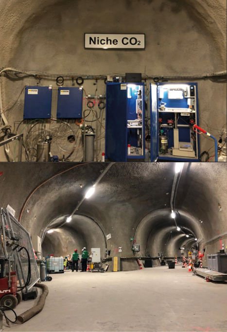
SMILE: MultidiSciplinary and MultIscale approach for assessing coupLed processes induced by geo-Energies

|
SMILE is a Marie Sklodowska-Curie doctoral network supported by the European Union's Horizon Europe framework program with the objective to train a new generation of young researchers for the successful deployment of subsurface low-carbon energy sources. The deployment of geothermal energy, and subsurface storage of energy and CO2 can help fight climate changes and limit the temperature increase as laid out in the Paris Agreement. However, some early geo-energy projects have occasionally developed unpredicted consequences, such as felt and damaging induced earthquakes, dampening public perception on geo-energies. The various processes involved in geo-resources exploitation (e.g., hydraulic, geomechanical, geochemical and thermal effects) imply complex interactions that cannot be predicted without considering the dominant coupled processes. SMILE seeks to overcome these obstacles in the development of geo-energy solutions by comprehending and forecasting linked processes. The trained researchers will have the ability to suggest creative ways to ensure that subterranean low-carbon energy sources are successfully deployed while safeguarding related ecosystems and groundwater. Doctoral candidates undergo interdisciplinary training in experimental, mathematical, and numerical modeling of coupled processes, upscaling techniques, and ground deformation monitoring using field data from pilot tests and industrial sites, enhancing their applicability in academia, industry, and public sector.
SED's participation in SMILE aims to develop an experimental study on the interaction between reactive pore fluids and rock matrix in caprocks and reservoir rocks. Data are collected at lab scale (e.g. the Rock Physics and Mechanics Lab, ETH Zurich) and in situ at pilot projects (e.g. Mont Terri, Bedretto Underground lab, as well as at Icelandic CO2 storage facilities), aiming to link mechanical/hydraulic parameters and fluid-rock interaction. The goal is to create a comprehensive dataset on geomechanical parameters related to fluid-rock interaction in caprock/reservoir rocks, which will be used in numerical simulations. |
|---|---|
| Project Leader at SED | Alba Zappone, Antonio Pio Rinaldi, Claudio Madonna |
| Funding Source | Horizon Europe program; State Secretariat for Education, Research and Innovation SERI |
| Duration | 2023-2027 |
| Keywords | Geothermal energy; geological carbon storage; technological development |
| Research Field | Geomechanical Modeling, Induced Seismicity, Laboratory Seismology |
| Link To Project Website |
DemoUpStorage
|
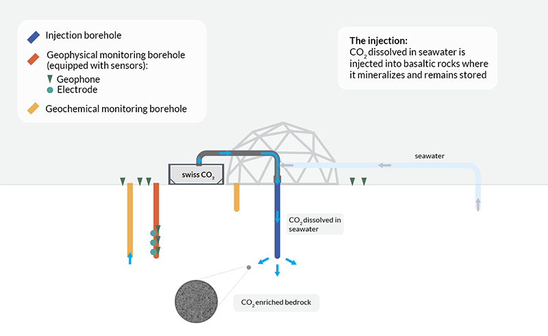
The Swiss Energy Strategy foresees CO2 capture and underground storage, possibly abroad, among the necessary measures to reach the net zero target by 2050. DemoUpCARMA, the partner project of DemoUpStorage, explores as one pathway to negative emissions the transport and storage of Swiss biogenic CO2 in Islandic basalt as well as this pathway’s potential for upscaling. Since a safe and permanent storage of the Swiss CO2 is an indispensable requirement, DemoUpStorage takes the lead in closely monitoring the injection and the dispersion of the Swiss CO2 in the Islandic underground at a site that has high potential for upscaling. For the injection, a novel technique is used, where the CO2 is dissolved in sea water instead of fresh water. The findings of DemoUpStorage will further advance the Swiss Roadmap for geological CO2 storage through knowledge acquisition and transfer, as well as capacity building. DemoUpStorage has the following objectives:
|
|---|---|
| Project Leader at SED | Prof. Dr. Stefan Wiemer |
| SED Project Members | Dr. Alba Zappone, Dr. Anne Obermann, Dr. AntonioPio Rinaldi, Dr. Michèle Marti, Dr. Irina Dallo, Stefanie Zeller, Jonas Junker |
| Funding Source | SFOE, FOEN |
| Duration | 2022 - 2024 |
| Keywords | CO2 storage, monitoring CO2 mineralization |
| Research Field | CO2 storage |
| Link To Project Website | |
| Publications |
Stavropoulou E, Laloui L (2023). CO2 storage in basalts: the impact of mineralisation on the hydromechanical response of the material. Proceedings of the 9ICEG 9th International Congress on Environmental Geotechnics 25-28 June, 2023 | Chania, Greece. doi: 10.53243/ICEG2023-115 |
ERM-CH23: Earthquake Risk Model of Switzerland
|
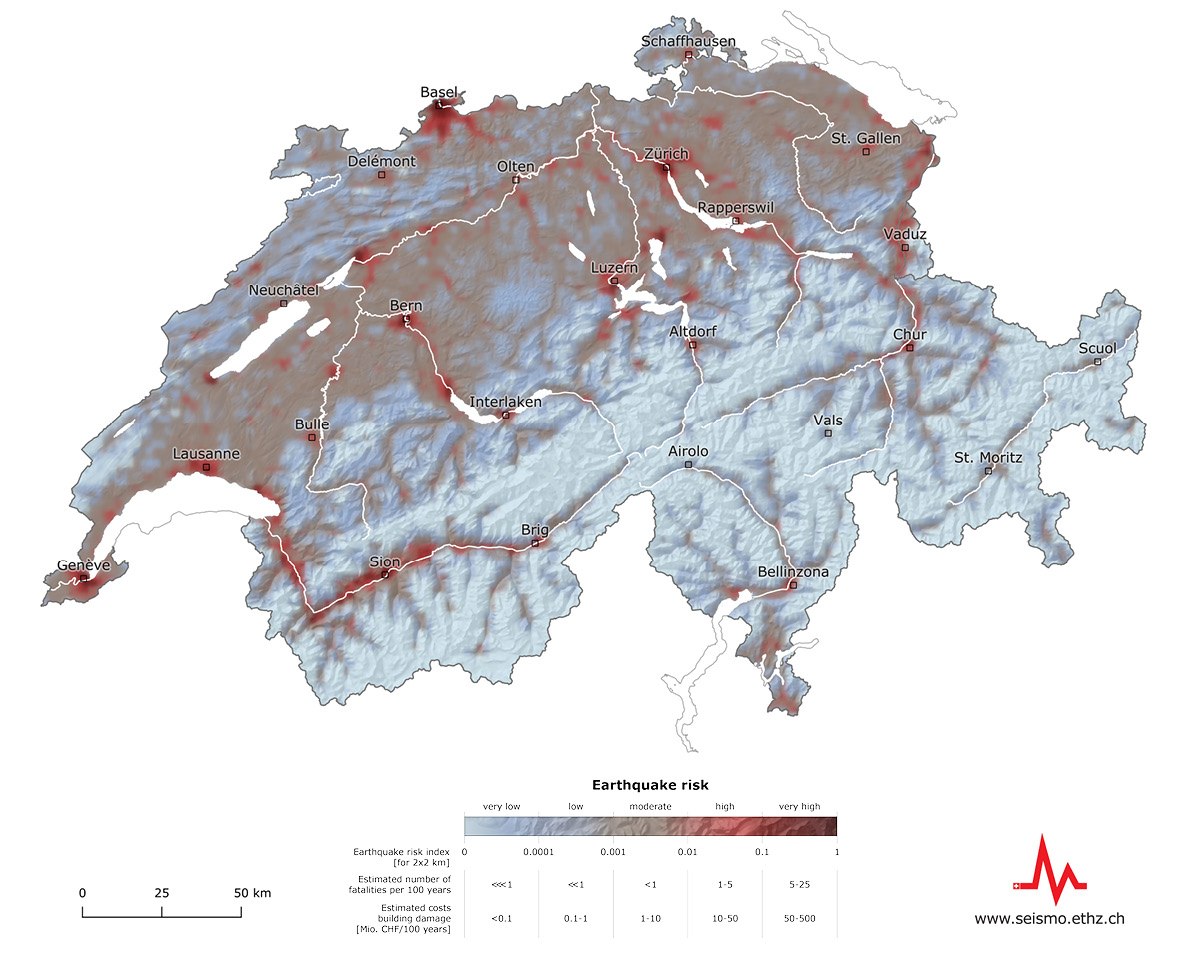
Phase 1 (2023-2027). Understanding earthquake risk at the national and sub-national levels is essential for developing effective policies and measures to mitigate this risk. The Earthquake Risk Model of Switzerland (ERM-CH23), developed between 2027 and 2022, and released in early 2023, is the culmination of a multidisciplinary effort to provide, for the first time, a comprehensive assessment of the potential consequences of earthquakes on the Swiss building stock and population. Developed as a national model, ERM-CH23 relies on very high-resolution site amplification and building exposure datasets, which distinguishes it from most regional models to date. Multiple loss types are evaluated, ranging from structural/nonstructural and contents economic losses, to human losses, such as fatalities, injuries and displaced population. Phase 2 (2023-2027). ERM-CH23 includes a variety of products designed to meet the needs of a very diverse audience. Earthquake scenarios quantify the losses caused by individual events and are typically used by cantonal authorities in preparedness exercises and help raise awareness of seismic risk among the general public. Rapid impact assessments, conducted in the immediate aftermath of an earthquake, help manage the consequences of a damaging earthquake. In the hours and days following an earthquake, they are the foundation upon which the Blue Light organizations rely in their response efforts. Probabilistic seismic risk calculations for individual building portfolios assess the financial exposure of entities responsible for insuring property owners in Switzerland. In the second project phase, the model undergoes further improvements, such as the introduction of daytime-dependent loss calculations and updates to administrative community layers. Model maintenance and data curation, ensuring compatibility with the ever-evolving OpenQuake software, and finally calculating different products to meet the needs of different stakeholders are important aspects of this phase. Additionally, outreach efforts and the development of learning modules are important activities to enhance understanding and preparedness. |
|---|---|
| Project Leader at SED | Prof. Stefan Wiemer, (coordinator: Philippe Roth) |
| Funding Source | SED / ETHZ, BABS, BAFU |
| Duration | Phase 1 (model development): 2017 – 2023, phase 2 (operational phase): 2023 – 2027 |
| Keywords | Seismic risk, preparedness, awareness, mitigation, event management |
| Research Field | Earthquake Hazard and Risk |
| Link To Project Website | |
| Publications |
Wiemer S., Papadopoulos A., Roth P., Danciu L., Bergamo P., Fäh D., Duvernay B., Khodaverdian A., Lestuzzi P., Odabaşi Ö., Fagà E., Bazzuro P., Cauzzi C., Hammer C., Panzera F., Perron V., Marti M., Valenzuela N., Dallo I., Zaugg S., Fulda D., Kästli P., Schmid N., Haslinger F. (2023). Earthquake Risk Model of Switzerland (ERM-CH23). Swiss Seismological Service, ETH Zurich. doi: 10.12686/a20 |
Induced Seismicity
GEOBEST2020+
|
As a local, versatile, clean, and renewable energy source, geothermal energy can contribute to achieving Switzerland’s energy and climate objectives. Worldwide, numerous geothermal projects have been successfully operating for decades. Unfortunately, some have also been aborted during the reservoir construction or operation phase. Today, adequate risk governance of induced seismicity is perceived as essential for establishing safe and economically viable geothermal projects. In Switzerland, the subsurface is under the sovereignty of the cantons. Therefore, the cantonal authorities in charge of the permitting, concessioning, and regulatory oversight must have access to independent, state-of-the-art seismological expertise. Furthermore, independent seismic monitoring and competent project oversight are important contributions to risk governance and can build and maintain public acceptance of geothermal projects. GEOBEST2020+ ensures that the Swiss Seismological Service (SED), the federal agency for earthquakes, can provide seismological expertise and baseline seismic monitoring services to the cantons at no cost and independently of the operators of geothermal projects: Seismological consulting:SED experts can support the cantonal authorities with:
Seismic monitoring and earthquake alarming:SED can provide the baseline seismic monitoring, including:
|
|---|---|
| Project Leader at SED | Dr. Toni Kraft |
| SED Project Members | Dr. Veronica Antunes, Dr. Vanille Ritz, Dr. Philippe Roth, Dr. Tania Toledo, Prof. Dr. Stefan Wiemer |
| Funding Source | |
| Duration | 2019-2027 |
| Keywords | Deep Geothermal Energy, Induced Seismicity, Induced Earthquake Hazard & Risk, Real-time monitoring, Support and consultancy |
| Research Field | Monitoring, Alerting and Analysis; Earthquake Processes |
| Link To Project Website |
GHTnet: Baseline Seismic Monitoring Construction 2nd tube Gotthard Highway Tunnel
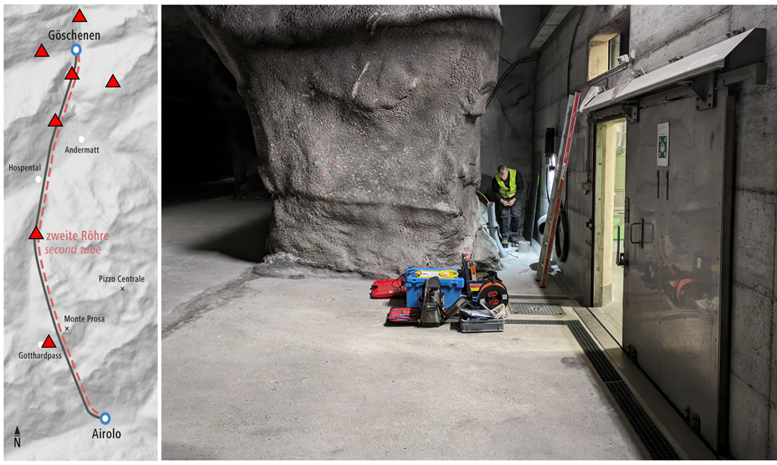
|
The Swiss Seismological Service at ETH Zurich (SED) is collaborating with the Federal Roads Office (FEDRO) to enhance seismic monitoring for the construction of the second tube of the Gotthard Highway Tunnel, which connects Göschenen, UR, and Airolo, TI. SED has recently deployed seven new seismic stations along the tunnel route to augment the capabilities of its automated seismological analysis system. This initiative aims to monitor both natural and mining-induced microearthquakes near the tunnel construction zones and the trajectories of the existing and new tunnel tubes, typically separated by approximately 75 meters. SED promptly provides FEDRO with earthquake alerts and comprehensive assessments for all detected seismic events, thereby contributing to the safe and efficient operation of tunnelling activities and highway traffic. |
|---|---|
| Project Leader at SED | Dr. Toni Kraft |
| Funding Source | |
| Duration | 2024-2027 |
| Keywords | Mining induced seismicty, Microseismic monitoring and analysis |
| Research Field | Microseismic Monitoring and Analysis, Induced Seismicity |
Fields of Research

Earthquake Early Warning
Earthquake Early Warning in Central America - Alerta Temprana de Terremotos en América Central (ATTAC)
|
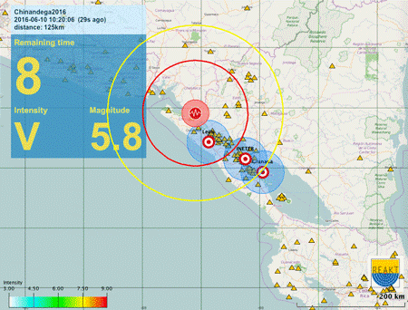
Scientists from the SED are working with local monitoring agencies from the region to build Earthquake Early Warning (EEW) across Central America. This multi-phase project is funded by the Swiss Agency for Development and Cooperation (SDC) at the Federal Department of Foreign Affairs (FDFA). In Phase 1 (2016-2017), SED worked with colleagues at INETER to evaluate the potential for EEW and to implement a prototype EEW system in Nicaragua. In Phase 2 (2018-2021), this prototype system was extended to include monitoring agencies in 3 additional countries - OVSICORI-UNA in Costa Rica, MARN in El Salvador, and INSIVUMEH in Guatemala. 70 EEW-ready strong motion accelerometers were purchased and deployed in the region. We further began to explore how a public EEW could be implemented, with EEW messages being integrated in the the emerging Digital-TV infrastructure as well as with a cellphone app developed within the project. In Phase 3 (2022-2024), we transition to operational EEW and public EEW messages using this cellphone app, and in the case of Guatemala City, an urban siren system. On 14 June 2023, the first public version of the cellphone app was released in Costa Rica. The region suffers from large tsunamigenic earthquakes generated along the subduction zone, and also moderate crustal earthquakes that have in the recent past produced heavy damage, such as the M6.2 1972 earthquake that devastated Managua. The subduction zone events are often characterized by slow rupture velocity (the M7.7 1992 earthquake - the first slow earthquake ever documented - and most recently a M7.3 in 2014) Earthquake Early Warning (EEW) is a tool that can rapidly characterize on-going earthquakes, and potentially provide seconds to 10s of seconds notification of impending strong shaking in advance of its occurrence. EEW can play an important role as part of a seismic risk reduction program, which is critical in the Central American region that has such a high seismic hazard. Additionally, making a seismic network capable of operating and maintaining an EEW system requires the network to achieve the highest standards in network performance - including station quality, speed and reliability of data communications, and robustness of the seismic network hub that runs the EEW software. Optimal network performance is also critical for other applications such as tsunami warning, volcano monitoring, and enables downstream scientific studies, eg on local Earth structure. EEW can work in Central America because the seismic networks are relatively dense and data sharing is well-established and effective - necessary as earthquakes can have impacts beyond a single country. On 9 June 2016, just weeks after the first software was installed and before efforts to optimise had begun, a shallow M6.3 event occurred on the border with El Salvador that was detected by our system after 29s. Though far from the delay time required for operational EEW, this did demonstrate the promise of the existing infrastructure. With the current seismic network and optimised system, we typically can provide first EEW alerts within 8-12s for shallow on-shore earthquakes. This corresponds to a blind zone on the order of 20-30km around the epicenter where no advanced warning will be available. Outside the blind zone, for large earthquakes, this type of EEW can provide warning in advance of the strongest shaking for areas that will experience shaking of intensity VI on the Modified Mercalli Scale. Transfer of EEW capacity from SED to Central American Institutes is feasible because each agency use the same basic software for seismic network monitoring - SeisComP3 - that the SED itself relies on, and on top of which we have added EEW capability. SED use 2 standard algorithms to provide EEW - the Virtual Seismologist and the Finite Fault Detector. We also have been using the EEW Display (EEWD) to deliver desktop alerts to early adopters and testers.
|
|---|---|
| Project Leader at SED | Dr. John Clinton |
| SED Project Members | Frédérick Massin, Roman Racine, Maren Böse |
| Funding Source | Swiss Agency for Development and Cooperation (DEZA / SDC) |
| Duration | Phase 3: Jan 2022 - March 2024; Phase 2: May 2018 - April 2021 (extension to December 2021); Phase 1: January 2016 - January 2018 |
| Keywords | Earthquake Early Warning, Seismic Networks, Nicaragua, Costa Rica, El Salvador, Guatemala, Central America, INETER, DEZA/SDC |
| Research Field | Earthquake Early Warning, Real-time monitoring, Network Seismology |
ShakeAlert (US Westcoast)
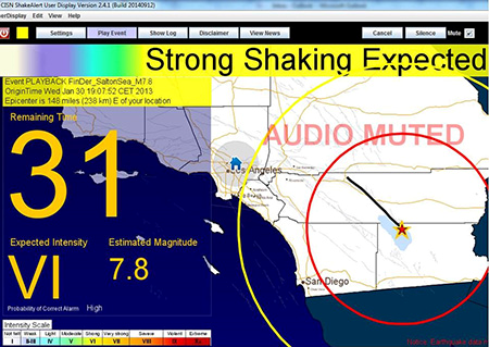
|
California, Oregon, and Washington are currently implementing a public earthquake early warning (EEW) system, called ShakeAlert. To detect earthquakes and to generate alerts, ShakeAlert feeds data from the seismic and geodetic networks operated along the US West Coast into two algorithms: the point-source EPIC (formerly known as ElarmS and Onsite), and the finite-source Finite-Fault Rupture Detector (FinDer) algorithm. Alert messages from EPIC and FinDer are aggregated into a single alert feed. ShakeAlert started in 2012 as a demonstration system for EEW and provided warnings of imminent strong ground shaking to a selected group of test users. At that stage, the Virtual Seismologist (VS; Cua and Heaton, 2009), implemented and tested by the SED, was part of the system. In 2013, California passed legislation to implement a public warning system. After the US Congress approved the funding in 2014, the transition to a public system started. A limited public roll-out of ShakeAlert started in California, Oregon, and Washington in the fall of 2018. About one year later the testing of public alerting on mobile devices (phones) was rolled out in California. Washington, and Oregon followed in 2021. Alerts can be received as Wireless Emergency Alerts (WEA) on mobile devices, as well as through apps (e.g. MyShake, QuakeAlertUSA, and ShakeReadySD), or through a ShakeAlert-powered earthquake alert feature that is integrated into the Android Operating System. The SED collaborates with the ShakeAlert team (US Geological Survey, Caltech, UC Berkeley, University of Washington, and University of Oregon) in the development, implementation, and testing of FinDer (Böse et al., 2012; Böse et al., 2015; Böse et al., 2018; Böse et al., 2023). |
|---|---|
| Project Leader at SED | Dr. Maren Böse |
| SED Project Members | Dr. Frederick Massin, Dr. Savas Ceylan, Dr. John Clinton |
| Funding Source | United States Geological Survey (USGS) |
| Duration | Since 2012 |
| Keywords | Earthquake early warning, real-time seismology |
| Research Field | Earthquake Early Warning |
| Link To Project Website | |
| Publications |
Böse, M., J. Andrews, R. Hartog, and C. Felizardo (2023). Performance and Next Generation Development of the Finite-Fault Rupture De-tector (FinDer) within the United States West Coast ShakeAlert Warning System. Bull. Seismol. Soc. Am. 113 2, 648-663. doi: 10.1785/0120220183 Chung, A., M. Meier, J. Andrews, M. Böse, B. Crowell, J. McGuire, D. Smith (2020). ShakeAlert Earthquake Early Warning System Performance during the 2019 Ridgecrest Earthquake Sequence. Bull. Seismol. Soc. Am. 110 (4), 1904–1923. doi: 10.1785/0120200032 Böse, M., D.E. Smith, C. Felizardo, M.-A. Meier, T.H. Heaton, J.F. Clinton (2018). FinDer v.2: Improved Real-time Ground-Motion Predictions for M2-M9 with Seismic Finite-Source Characterization. Geophys. J. Int. 212, 725-742. Behr, Y., J. F. Clinton, P. Kästli, C. Cauzzi, and M.-A. Meier (2015). Anatomy of an Earthquake Early Warning (EEW) Alert : Predicting Time Delays for an End-to-End EEW System. Seismol. Res. Lett. 86 (3), 1-11. doi: 10.1785/0220140179 Meier, M.-A., T. Heaton, and J. Clinton (2015). The Gutenberg Algorithm: Evolutionary Bayesian Magnitude Estimates for Earthquake Early Warning with a Filter Bank. Bull. Seismol. Soc. Am. 105 (5), 2774-2786. doi: 10.1785/0120150098 Böse, M., C. Felizardo, & T.H. Heaton (2015). Finite-Fault Rupture Detector (FinDer): Going Real-Time in Californian ShakeAlert Warning System. Seismol. Res. Lett. 86 (6), 1692-1704. Böse, M., R. Graves, D. Gill, S. Callaghan, and P. Maechling (2014). CyberShake-Derived Ground-Motion Prediction Models for the Los Angeles Region with Applica-tion to EEW. Geophys. J. Int. 198 (3), 1438-1457. Given, D.D., Cochran, E.S., Heaton, T., Hauksson, E., Allen, R., Hellweg, P., Vidale, J., and Bodin, P. (2014). Technical implementation plan for the ShakeAlert production system—An Earthquake Early Warning system for the West Coast of the United States. U.S. Geological Survey Open-File Report 2014–1097, 25. doi: 10.3133/ofr20141097 Böse, M., R. Allen, H. Brown, C. Cua, M. Fischer, E. Hauksson, T. Heaton, M. Hellweg, M. Liukis, D. Neu-hauser, P. Maechling, P. and CISN EEW Group (2013). CISN ShakeAlert – An Earthquake Early Warning Demonstration System for California. In: F. Wenzel and J. Zschau: Early Warning for Geological Disasters - Scientific Methods and Current Practice (ISBN: 978-3-642-12232-3). Springer Berlin Heidelberg New York: Böse, M., T.H. Heaton, & E. Hauksson (2012). Real-time Finite Fault Rupture Detector (FinDer) for Large Earthquakes. Geophys. J. Int. 191 (2), 803-812. Böse, M., T. Heaton and E. Hauksson (2012). Rapid estimation of earthquake source and ground-motion parameters for earthquake early warning using data from single three-component broadband or strong-motion sensor. Bull. Seismol. Soc. Am. 102 (2), 738-750. doi: 10.1785/0120110152 Böse, M. & T.H. Heaton (2010). Probabilistic Prediction of Rupture Length, Slip and Seismic Ground Motions for an Ongoing Rupture: implications for Early Warning for Large Earthquakes. Geophys. J. Int. 183 (2), 1014-1030. doi: 10.1111/j.1365-246X.2010.04774.x Cua, G. B., M. Fischer, T. H. Heaton, and S. Wiemer (2009). Real-time Performance of the Virtual Seismologist Earthquake Early Warning Algorithm in Southern California. Seismol. Res. Lett. 80 (5), 740-747. doi: 10.1785/gssrl.80.5.740 |
| Presentations |
Laboratory Seismology
CRITICAL-P: Towards a physical understanding of critical phenomena in the pre-failure damage of rock – Improvements in forecasting natural and induced earthquakes
|
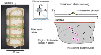
The localization of crustal deformation introduces an important aspect in assessing earthquake generation. This is potentially linked to the presence of a critical point at failure, yet this link remains poorly understood. Here, we present laboratory observations of the evolving strain field in triaxially compressed sandstone, using fiber optic sensing (FOS) and acoustic emission (AE) data sets to measure localized strain and deformation with high spatial and temporal resolution. The project aims at analyzing where in the deformation records a phase transition between the intact and failed phase in the rock exists. This process may or may not exists and can be significantly affected by the presence of fluid or temperature. However, being able to identify if it occurs offers insight into illusive physics-based predictive model that could provide constraints for forecasting models of earthquakes under complex tectonic conditions. |
|---|---|
| Project Leader at SED | Dr. Paul Antony Selvadurai |
| Funding Source | |
| Duration | 2022-2025 |
| Keywords | Criticality, brittle rock failure, disordered materials |
| Research Field | Laboratory Seismology |
Realtime Monitoring
MontTerri projects
|
The Mont Terri Rock Laboratory provides an underground infrastructure for conducting long-term experiments (years to decades) in clay rock, the Opalinus Clay, at a decametric to hectometer scale. This facility uniquely bridges the gap between typical laboratory experiments and pilot projects, incorporating the complexity of an in-situ setting while maintaining a high level of control over the experimental environment due to the extensive understanding of the clay formation.
SED, as partner in the Mont Terri Consortium, is active since many years in multiple experiments, as of principal investigator (*) or in partnership with other scientific and industrial organizations. The SED provides in-kind contributions as well as direct funding from European and/or national funding agencies. The projects cover a large variety of research topics, and often have an immediate applicability for industry.
CS-E (*): Mini-fracturing and Sealing (2021-2027) builds on the observations of the previous CS-D experiment (2018-2021). The primary objective is to understand the reactivation of individual, small fractures within the Mont Terri Main Fault. This involves a series of low flow rate, high pressure "mini-stimulations" to open pre-existing small fractures. The experiment aims to develop strategies to mitigate caprock failure during storage activities, and investigates on the use of sealants to be injected into the fault zone. It addresses critical research questions under geological conditions relevant to Switzerland, supporting the implementation of the Swiss national roadmap on carbon capture and storage.
FS-B: Imaging the long term loss of fault rock integrity (2015-2027) aims to image short-term fluid flow, permeability, and stress variations through a minor fault to evaluate the performance of radioactive waste repositories in shale. Its results can also inform CO2 storage security and cap-rock integrity. FS-B involves repeated seismic imaging of fluid flow and stress variations during controlled fault activation by fluid injection, with continued monitoring afterward to characterize the permeability evolution of the stimulated fault.
FS-E: Distributed hydromechanical response during fault damage and fault self-sealing evolution (2023-2027). Using an unprecedented 10cm resolution distributed optical fiber method, the goal of the experiment is to explore the in situ time-lapse coupling of pore pressure, strain, and structures associated with the long-term sealing process following the fault zone activation (after the FS-B activation). Few studies have investigated the long-term hydromechanical behavior of a fault years after activation. FS-E results could also be used to assess the long-term integrity and security of host rocks and CO2 storage.
GT: Gas transport models and the behavior of clay rocks under gas pressure (2022-2026). In geological waste repositories, gas is mainly generated by the corrosion of metals. The low permeability of clay rock can cause gas accumulation, increasing pressure and potentially fracturing the host rock. Waste processing or engineered gas transport systems are proposed as mitigation measures. In clay-rich formations, it is uncertain whether gas can escape without causing fractures and creating pathways for groundwater transport. Understanding these processes is incomplete, and a comprehensive mathematical framework is still lacking. The experiment includes both laboratory and field components.
PF-A: Progressive evolution of structurally controlled overbreaks - Long-term monitoring, hydromechanical simulation and rock testing (2023-2026). From 2020 to 2023, the PF experiment investigated damage initiation and propagation in faulted Opalinus Clay rock above a large-diameter borehole. Initially, it examined the effects of ventilation and rock desaturation, followed by re-saturation. With the ongoing PF-A experiment the focus move on the long-term (3.5 to 7.5 years) evolution of rock mass damage and structurally-controlled over-breaks. Novel survey and monitoring techniques revealed reduced rock resistivities and subtle changes in seismic velocities, indicating evolving water flow paths linked to rock mass damage. Numerical simulations assessed the short-term mechanical behavior of the faulted rock mass. PF-A continues in-situ surveying and monitoring at a reduced frequency to establish long-term datasets. Advanced simulations aim to develop a 3D model for coupled flow and deformation phenomena, investigate subcritical crack growth effects on overbreaks, and validate a numerical model for predicting repository tunnel behavior in fractured rock. |
|---|---|
| Project Leader at SED | Alba Zappone, Antonio Pio Rinaldi, Anne Obermann |
| Funding Source | Varia (see summary) |
| Duration | 2015-2028 |
| Keywords | Geological Carbon Storage; Fault Stability, Caprock Integrity, Technological Development |
| Research Field | Geomechanical Modeling, Induced Seismicity, Seismic Interferometry and Imaging, Mont Terri |
| Link To Project Website | |
| Publications |
Ziegler, M., Furche, M., Beilecke, T., Burschil, T., Obermann, A., Lei, Q., Zhao, C., Loew, S. (2024). Monitoring damage evolution in a tectonically faulted clay shale - an experiment of the Mont Terri . ISRM conference paper. Weber, U.W. Rinaldi, A. P., et al. (2023). Geochemical Insight into CO2 Migration in a Faulted Caprock. Research Square. doi: 10.21203/rs.3.rs-2386526/v1 Brennwald, M. S., Rinaldi, A. P., Gisiger, J., Zappone, A. and Kipfer R. (2023). Gas-Equilibrium Membrane Inlet Mass Spectrometery (GE-MIMS) for water at high pressure. Geoscientific Instrumentation, Methods and Data Systems. doi: 10.5194/gi-13-1-2024 Grab, M., Rinaldi, A. P, Wenning, Q. C., Hellmann, S., Roques, C., Obermann, A. C., Maurer, H., Giardini, D., Wiemer, S., Nussbaum, C., Zappone, A. (2022). Fluid pressure monitoring during hydraulic testing in faulted Opalinus Clay using seismic velocity observations. Geophysics. doi: 10.1190/geo2021-0713.1 Hopp, C., Guglielmi, Y., Rinaldi, A. P., Soom, F., Wenning, Q., Cook, P., Robertson, M., Kakurina M., Zappone A. (2021). The effect of fault architecture on slip behavior in shale revealed by distributed fiber optic strain sensing. Journal of Geophysical Research: Solid Earth. doi: 10.1002/essoar.10507120.1 Wenning Q., Madonna C., Kurotori T., Petrini C., Hwang J., Zappone A., Wiemer S., Giardini D., Pini R. (2021). Chemo-mechanical coupling in fractured shale with water and hydrocarbon flow. Geophysical Research Letters. doi: 10.1029/2020GL091357 Wenning Q., Madonna C., Zappone A., Grab M., Rinaldi A.P., Ploetze M., Nussbaum C., Giardini D., Wiemer S. (2021). Shale fault zone structure and stress dependant anisotropic permeability and seismic velocity properties (Opalinus clay, Switzerland). Journal of Structural Geology. doi: 10.1016/j.jsg.2020.104273 Zappone A. Rinaldi A.P., Grab M., Wenning Q., Roques C., Madonna C., Obermann A., Bernasconi S. M., Soom F., Cook P., Guglielmi Y., Nussbaum C., Giardini D., Wiemer S. (2020). Fault sealing and caprock integrity for CO2 storage: an in-situ injection experiment. Solid Earth Discussion. doi: 10.5194/se-2020-100 |
ArtEmis: Awareness and resilience through European multi sensor system

|
ArtEmis will design, build, and operate a smart and scalable multi sensor system comprising of about 100-200 novel low-cost geochemical sensors, that will measure with unprecedent spatial and temporal resolution changes in radon concentration in ground water, together with other observables like temperature and acidity. |
|---|---|
| Project Leader at SED | Michael Strupler |
| SED Project Members | Stefan Wiemer, Michael Strupler (former member) |
| Funding Source | European Union |
| Duration | 48 months; project start: 1 October 2022 |
| Keywords | Radon, Earthquakes, Sensors, Machine Learning, Awareness |
| Research Field | Real-time monitoring, Earthquake Statistics |
Engineering Seismology
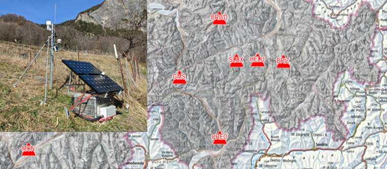
Detection, characterization and monitoring of instabilities with seismic technologies
|
In recent years, we have developed efficient geophysical and seismological measurement tools that enable the characterization of instabilities based on their vibrational behavior and are suitable for monitoring. New methods for the characterization of rock instabilities in terms of extent, volume, and condition, have been developed along with a derived classification and corresponding measurement strategies. Additionally, continuous long-term observations with seismometers have been developed. In the future, such tools will increasingly contribute to quantifying the risks of spontaneous and earthquake-induced instability failures and complement conventional techniques.
Currently, real-time monitoring of instabilities is the only way to provide continuous information for risk assessment and early warning before an event occurs. With seismic monitoring, we are able to monitor the internal properties (stiffness, vibration behavior, amplification, damping, vibration polarization) of the instability with a very high precision. This new component could become standard practice due to its high sensitivity to changes in slope characteristics. The combination of our monitoring, seismic site characterization, integration of deformation measurements and environmental data, and numerical modeling will provide insights into the driving factors of slope failure, and contribute to hazard and risk assessment of unstable slopes.
The aim of this applied project is the national implementation of the developed methods. The work includes the practical continuation of existing measurement sites in order to apply the methods in practice. Our contribution will show how vibration measurements can be used in the future to quickly characterize potential slope instabilities in terms of extent, volume and condition, and how the interpretation can contribute to the optimal placement of measuring systems (seismic, GNSS, total station, etc.). |
|---|---|
| Project Leader at SED | Prof. Donat Fäh |
| SED Project Members | Franziska Glüer, Mauro Häusler, Xavier Borgeat |
| Funding Source | Bundesamt für Umwelt 00.5032.PZ/ EC049A5A7 |
| Duration | 2023-2025 |
| Keywords | Earthquake induced mass movements, unstable rock-slopes, real-time monitoring, seismic methods |
| Research Field | Earthquake Hazard and Risk, Geo Risks |
| Publications |
Borgeat, X., Glueer, F., Häusler, M., Hobiger M. and D. Fäh (2024). On the variability of the seismic response of the active rock slope in Brienz/Brinzauls (Switzerland). Planned for submission to Geophysical Journal International. Burjánek, J., Gischig, V., Moore, J.R. and Fäh, D. (2018). Ambient vibration characterization and monitoring of a rock slope close to collapse. Geophys. J. Int. 212, 297-310. doi: 10.1093/gji/ggx424ss Burjanek, J., Kleinbrod, U., & Fäh, D. (2019). Modeling the Seismic Response of Unstable Rock Mass With Deep Compliant Fractures. Journal of Geophysical Research-Solid Earth 124)12), 13039-13059. doi: 10.1029/2019JB018607 Cauzzi, C., Fäh, D., Wald, D.J., Clinton, J., Losey, S. and S. Wiemer (2018). ShakeMap-based prediction of earthquake-induced mass movements in Switzerland calibrated on historical observations. Natural Hazards 92 (2), 1211-1235. Glueer, F., Häusler, M., Gischig, V. and Fäh, D. (2021). Coseismic Stability Assessment of a Damaged Underground Ammunition Storage Chamber Through Ambient Vibration Recordings and Numerical Modelling. Front. Earth Sci. doi: 10.3389/feart.2021.773155 Glueer, F., Mreyen, A.-S., Cauchie, L., Havenith, H.-B., Bergamo, P., Halló, M., & Fäh, D. (2024). Integrating Seismic Methods for Characterizing and Monitoring Landslides: A Case Study of the Heinzenberg Deep-Seated Gravitational Slope Deformation (Switzerland). Geosciences 14 (2), 28. doi: 10.3390/geosciences14020028 Häusler, M., Michel, C., Burjanek, J., & Fäh, D. (2019). Fracture Network Imaging on Rock Slope Instabilities Using Resonance Mode Analysis. Geophysical Research Letters 46 (12), 6497-6506. doi: 10.1029/2019gl083201 Häusler, M., Glueer, F., Burjánek, J., & Fäh, D. (2020). Chasing a hidden fracture using seismic refraction tomography: case study Preonzo, Switzerland. EGU2020-9701. In: Paper presented at the EGU General Assembly. doi: 10.5194/egusphere-egu2020-9701 Häusler, M., Michel, C., Burjánek, J., and Fäh, D. (2021). Monitoring the Preonzo rock slope instability using resonance mode analysis. J. Geophys. Res. Earth Surf. doi: 10.1029/2020JF005709 Häusler, M., Gischig, V., Thöny, R., Glueer, F. and Fäh, D. (2021). Monitoring the changing seismic site response of a fast-moving rockslide (Brienz/Brinzauls, Switzerland). Geophysical Journal International 229 (1), 299-310. doi: 10.1093/gji/ggab473 Häusler, M., Glueer, F., & Fäh, D. (2024). The changing seismic site response of the Brienz/Brinzauls rock slope instability: insights from 5 years of monitoring before, during and after a partial collapse in June 2023. ICL open access book series “Progress in Landslide Research and Technology”, 2-12. Kleinbrod, U., Burjánek, J., Fäh, D. (2017). On the seismic response of instable rock slopes based on ambient vibration recordings. Earth. Planets and Space. doi: 10.1186/s40623-017-0712-5 Kleinbrod, U., Huggentobler, M., Burjánek, J., Aman, F., Fäh, D. (2017). A comparative study on seismic response of two unstable rock slopes within same tectonic setting but different activity level. Geophys. J. Int 211 (3), 1428-1448. doi: 10.1093/gji/ggx376 Kleinbrod, U., Burjanek, J., & Fah, D. (2019). Ambient vibration classification of unstable rock slopes: A systematic approach. Engineering Geology 249, 198-217. doi: 10.1016/j.enggeo.2018.12.012 Oprsal, I., Thun, J., Burjánek, J. and D. Fäh (2020). Measurements and modeling of the post-failure micro-deformations and tilts of the Preonzo unstable slope, Alpe di Roscioro, Switzerland. Engineering Geology. doi: 10.1016/j.enggeo.2020.105919 Weber, S., Fäh, D. Beutel., J., Faillettaz, J., Gruber, S., Vieli, A. (2018). Ambient seismic vibrations in steep bedrock permafrost used to infer variations of ice-fill in fractures. Earth and Planetary Science Letters, 119-127. doi: 10.1016/j.epsl.2018.08.042 Weber, S., Beutel, J., Häusler, M., Geimer, P.R., Fäh, D. and Moore, J.R (2021). Spectral amplification of ground motion linked to resonance of large-scale mountain landforms. Earth and Planetary Science Letters. doi: 10.1016/j.epsl.2021.117295 |
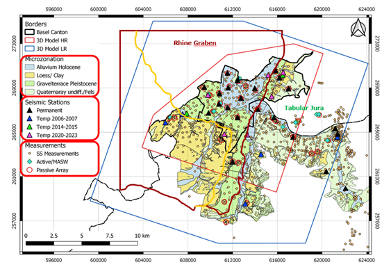
Microzonation in the Cantons Basel-Stadt and Basel-Landschaft
|
If a spectral microzonation study is published by the responsible authority, this must be used to determine the site-specific earthquake impact in accordance with the Swiss standard SIA 261. Accordingly, the response spectra based on the microzonation study published in 2009 were previously used in the canton of Basel-Stadt and in parts of the canton of Basel-Landschaft. With the revision of the SIA 261 and SIA 261/1 standards published in 2020, there was reason to review and update the existing microzonation study. In addition, numerous new observation data and reference data have been collected since 2009. The findings can be applied in a microzonation study.
The cantons of Basel-Stadt and Basel-Landschaft have therefore decided to launch a project to revise the microzonation. This microzonation is based on implementation and extension of the amplification models from the work in the Basel earthquake risk model project (2018-2024). The procedure for determining the microzones and their elastic response spectra corresponds to that of the SIA261/1 standard. The microzones are defined with the help of geological and geophysical data. Particular care is taken to ensure that the uncertainties in the models are not too large. For this reason, temporary seismic stations were installed in areas with large uncertainties in the amplification models. Geophysical investigations are also planned. The application of microzonation is simplified by limiting the number of microzones. This is done by combining areas with similar amplification of the earthquake waves. Possible earthquake-induced phenomena will be mapped in analogy to the reference maps of the 2009 microzonation. The project is being carried out in collaboration with the Applied Geology Group (AUG) of the University of Basel, the Chemical and Biosafety Control Authority and the Department of Justice and Security of the Canton of Basel-Stadt, and the Department of Construction and Environmental Protection of the Canton of Basel-Landschaft. |
|---|---|
| Project Leader at SED | Prof. Donat Fäh |
| SED Project Members | Afifa Imtiaz, Anastasiia Shynkarenko, Dario Chieppa, Paolo Bergamo |
| Funding Source | Kontrollstelle für Chemie- und Biosicherheit und Justiz- und Sicherheitsdepartement des Kantons Basel-Stadt; Bau- und Umweltschutzdirektion des Kantons Basel-Landschaft |
| Duration | 2023-2026 |
| Keywords | Site-effects, microzonation, building codes |
| Research Field | Earthquake Hazard and Risk, Engineering Seismology |
Earthquake Risk Model Basel-Stadt
The project Earthquake Risk Model Basel-Stadt (ERM-BS) 2019 to 2023 aims at developing a site specific seismic hazard and risk framework for the Swiss canton of Basel-Stadt. It is a follow-up of the projects Microzonation (2003 - 2009) and Basel Erdbebenvorsorge (2013 - 2016) funded by the canton of Basel-Stadt in its effort to set an earthquake risk mitigation and crisis management strategy for the canton. This project makes a step forward by attempting to develop a 3D integrated geological-seismological model of Basel, which will explicitly account for the complex geological conditions at the surface and at depth. Ground motion amplification models will be developed and validated with earthquake recordings from the permanent and temporary seismic network in the region. |
|
| Project Leader at SED | Prof. Donat Fäh |
|---|---|
| SED Project Members | Afifa Imtiaz, Francesco Panzera |
| Funding Source | Kanton Basel-Stadt |
| Duration | 2019-2023 |
| Keywords | 3D model, Basel city, ground motion amplification, seismic network, site effects, cantonal building database, seismic vulnerability, seismic risk |
| Research Field | Engineering Seismology, Seismic Hazard & Risk |
ENSI - Seismological research concerning Swiss nuclear installations
|
The forth phase of this project is split into 3 subtasks with the main goal to improve regional and local seismic hazard assessment in Switzerland; with particular focus to the sites of potential regions of nuclear repositories. These sub-projects are: The focus of sub-project 1 lies in the development and improvement of earthquake ground-motion attenuation and source-scaling models for Switzerland. We target ground-motion estimates for sites in the near field (at the soil surface and at depth) for damaging events; we also target smaller induced earthquakes. The work is based on observations in Switzerland and Japan. Studying the near-surface amplification and attenuation constitutes a key point in our research. The scope of sub-project 2 is to improve deterministic predictions of ground motion, especially concerning near-field, nonlinear behavior in sedimentary rocks and soft soils, and new approaches for modelling complex source processes. This includes the calibration of material parameters via field measurements and the development of numerical codes to simulate ground motion in three-dimensional complex media. The results of subproject 1 will be linked to deterministic simulations from Subproject 2, and the results will be tested and compared to observed data. In sub-project 3, the aim is to develop a time-dependent earthquake forecasting model which during an ongoing seismic crisis can answer questions related to the probability of the occurrence of large earthquakes in the near future. This includes the development and testing of a model de-scribing the time-dependent seismic hazard, the establishment of communication products that translate the model output into useful information for ENSI, and the assessment of the applicability of earthquake early warning in Switzerland. |
|---|---|
| Project Leader at SED | Prof. Donat Fäh
|
| SED Project Members | Maria Koroni, Jaleena Sunny, Leila Mizrahi, Paulina Janusz, Paolo Bergamo |
| Funding Source | Swiss Federal Nuclear Safety Inspectorate - ENSI |
| Duration | 2010-2014 (1st phase), 2014-2018 (2nd phase), 2018-2022 (3rd phase), 2022-2026 (4th phase) |
| Keywords | Ground motion prediction equations, ground motion modelling, induced seismicity |
| Research Field | Earthquake Hazard & Risk, Earthquake Processes |
| Reports / Deliverables |
D. Fäh, S. Wiemer, D. Roten, B. Edwards, V. Poggi, C. Cauzzi, J. Burjanek, M. Spada, R. Grolimund, M. Gisler, G. Schwarz-Zanetti, P. Kästli (2012). Expertengruppe Starkbeben. ENSI Erfahrungs- und Forschungsbericht 2011, 173-182. Eidgenösisches Nuklearsicherheitsinspektorat ENSI. PDF D. Fäh, S. Wiemer, B. Edwards, V. Poggi, D. Roten, R. Grolimund, M. Spada, J. Wössner (2013). Expertengruppe Starkbeben. ENSI Erfahrungs- und Forschungsbericht 2012, 173-181. Eidgenösisches Nuklearsicherheitsinspektorat ENSI. PDF D. Fäh, S. Wiemer, B. Edwards, V. Poggi, D. Roten, R. Grolimund, M. Spada, B. Schechinger, J. Woessner (2014). Expertengruppe Starkebeben. ENSI Erfahrungs- und Forschungsbericht 2013, 161-170. Eidgenösisches Nuklearsicherheitsinspektorat ENSI. PDF D. Fäh, S. Wiemer, B. Edwards, V. Poggi, D. Roten, R. Grolimund, M. Spada, B. Schechinger , T. Tormann, J. Woessner (2015). Earthquake Strong Motion Research. ENSI Erfahrungs- und Forschungsbericht 2014, 171-180. Eidgenösisches Nuklearsicherheitsinspektorat ENSI. PDF D. Fäh, S. Wiemer, B. Edwards, V. Poggi, M. Pilz, W. Imperatori, A. Rinaldi, L. Urpi (2016). SED – Erdbebenforschung zu Schweizer Kernanlagen. ENSI Erfahrungs- und Forschungsbericht 2015, 177-183. Eidgenössisches Nuklearsicherheitsinspektorat ENSI. PDF D. Fäh, S. Wiemer, M. Pilz, W. Imperatori, A. Rinaldi, L. Urpi (2017). SED – Erdbebenforschung zu Schweizer Kernanlagen. ENSI Erfahrungs- und Forschungsbericht 2016, 179-186. Eidgenössisches Nuklearsicherheitsinspektorat ENSI. PDF D. Fäh, S. Wiemer, M. Pilz, S. Bora, W. Imperatori, A. Rinaldi, L. Urpi, P. Bergamo (2018). SED – Erdbebenforschung zu Schweizer Kernanlagen. ENSI Erfahrungs- und Forschungsbericht 2017, 199-207. Eidgenössisches Nuklearsicherheitsinspektorat ENSI. PDF D. Fäh, S. Wiemer, S. Bora, W. Imperatori, A. Rinaldi, L. Urpi, P. Bergamo (2019). SED – Erdbeben-forschung zu Schweizer Kernanlagen. ENSI Erfahrungs- und Forschungsbericht 2018, 197-206. Eidgenössisches Nuklearsicherheitsinspektorat ENSI. Link D. Fäh, S. Wiemer, W. Imperatori, P. Bergamo, L. Urpi, M. Hallo, S. Bora (2020). SED – Erdbebenforschung zu Schweizer Kernanlagen. ENSI Erfahrungs- und Forschungsbericht 2019, 199-206. Eidgenössisches Nuklearsicherheitsinspektorat ENSI. PDF D. Fäh, S. Wiemer, W. Imperatori, P. Bergamo, M. Hallo, A. P. Rinaldi (2021). SED – Erdbebenforschung zu Schweizer Kernanlagen. ENSI Erfahrungs- und Forschungsbericht 2020, 179-186. Eidgenössisches Nuklearsicherheitsinspektorat ENSI. PDF D. Fäh, S. Wiemer, W. Imperatori, M. Hallo, P. Bergamo, A. P. Rinaldi (2022). SED – Erdbebenforschung zu Schweizer Kernanlagen. ENSI Erfahrungs- und Forschungsbericht 2021, 204-212. Eidgenössisches Nuklearsicherheitsinspektorat ENSI. PDF D. Fäh, S. Wiemer, M. Hallo, M. Koroni, A. P. Rinaldi, P. Bergamo (2023). SED – Erdbebenforschung zu Schweizer Kernanlagen. ENSI Erfahrungs- und Forschungsbericht 2022, 208-2018. Eidgenössisches Nuklearsicherheitsinspektorat ENSI. PDF D. Fäh, S. Wiemer, M. Hallo, M. Koroni, L. Mizrahi, P. Bergamo (2024). SED – Erdbebenforschung zu Schweizer Kernanlagen. ENSI Erfahrungs- und Forschungsbericht 2023, 207-216. Eidgenössisches Nuklearsicherheitsinspektorat ENSI. PDF |
Quantification of the seismic response of instable slopes and its time variability: an important indicator for potential mass movements
|
Geophysical and seismological tools have advanced in recent years, enabling the study of slope instabilities with more precision. These tools analyze the vibrational behavior and earthquake response of slopes, which can provide valuable information about their stability. However, while these tools can detect, map, and monitor potentially instable slopes, there is still limited understanding of the influence of environmental conditions on their seismic behavior. To address this gap in knowledge, this project aims to investigate the relationship between environmental factors and slope stability. We will perform repeated short-term field measurements and continuous monitoring to focus on examining the relationship between temperature, precipitation, groundwater levels and permafrost on the vibrational behavior of instabilities. These insights can then be used to classify instabilities and understand their movement and behavior.
The project findings aim to significantly impact the prevention of human casualties and damage to infrastructure, as well as cultural and natural heritage, caused by landslides. A better understanding of the influence of environmental factors on the seismic signature of slopes and slope behavior will enhance hazard analysis and risk assessment. This, in turn, will help to protect communities and infrastructure in areas directly or indirectly threatened by landslides. |
|---|---|
| Project Leader at SED | Prof. Donat Fäh |
| SED Project Members | Franziska Glüer, Mauro Häusler, Xavier Borgeat, Urs Fässler |
| Funding Source | |
| Duration | 2023-2025 |
| Keywords | Earthquake induced mass movements, unstable rock-slopes, real-time monitoring |
| Research Field | Earthquake Hazard and Risk, Geo Risks |
| Publications |
Borgeat, X., Glueer, F., Häusler, M., Hobiger, M., & Fäh, D. (2024). On the variability of the site-response parameters of the active rock slope in Brienz/Brinzauls (Switzerland). In submission to Geophysical Journal International . Glueer, F., Mreyen, A.-S., Cauchie, L., Havenith, H.-B., Bergamo, P., Halló, M., & Fäh, D. (2024). Integrating Seismic Methods for Characterizing and Monitoring Landslides: A Case Study of the Heinzenberg Deep-Seated Gravitational Slope Deformation (Switzerland). Geosciences 14(2), 28. doi: 10.3390/geosciences14020028 Häusler, M., Gischig, V., Thöny, R., Glueer, F., & Fäh, D. (2022). Monitoring the changing seismic site response of a fast-moving rockslide (Brienz/Brinzauls, Switzerland). Geophysical Journal International, 229-310. doi: 10.1093/gji/ggab473 Häusler, M., Glueer, F., & Fäh, D. (2024). The changing seismic site response of the Brienz/Brinzauls rock slope instability: insights from 5 years of monitoring before, during and after a partial collapse in June 2023. ICL open access book series “Progress in Landslide Research and Technology”, 2-12. |
Site Characterization Research
|
This working group gathers the researchers with competences in site characterization in order to discuss and improve the work performed in different projects, especially for sites with new permanent seismic stations. The available tools for processing, archiving and disseminating are shared within the group. The group is responsible for setting up and updating the SED database for site characterization. The group meets regularly to discuss new results and to review the work before it is published. |
|---|---|
| Project Leader at SED | Prof. Donat Fäh |
| SED Project Members | Paolo Bergamo, Dario Chieppa, Franziska Glüer, Miroslav Hallo, Mauro Häusler, Afifa Imtiaz, Agostiny Lontsi, Francesco Panzera, Paulina Janusz, Anastasiia Shynkarenko |
| Funding Source | Actual projects with site characterization work: Strong motion renewal project phase 2; Earthquake risk model for Switzerland; Earthquake risk model for Basel; 4D seismic response and slope failure; Lake Tsunamis: causes, consequences and hazard; and others) |
| Duration | 2010 - present |
| Keywords | Site characterization, strong motion stations, broadband stations, site response, site effects, site amplification |
| Research Field | Earthquake Hazard & Risk, Engineering Seismology |
| Link To Project Website | |
| Publications |
Bergamo., P., Hammer, C. and Fäh, D. (2021). Correspondence between Site Amplification and Topographical, Geological Parameters: Collation of Data from Swiss and Japanese Stations, and Neural Networks‐Based Prediction of Local Response. Bulletin of the Seismological Society of America 112 (2). Link doi: 10.1785/0120210225 Michel, C., Fäh, D., Edwards, B., & Cauzzi, C. (2017). Site amplification at the city scale in Basel (Switzerland) from geophysical site characterization and spectral modelling of recorded earthquakes. Physics and Chemistry of the Earth, Parts A/B/C 98, 27-40. doi: 10.1016/j.pce.2016.07.005 Poggi, V., Burjanek, J., Michel, C., & Fäh, D. (2017). Seismic site-response characterization of high-velocity sites using advanced geophysical techniques: application to the NAGRA-Net. Geophysical Journal International 210(2), 645–659. doi: 10.1093/gji/ggx192 Michel, C., Edwards, B., Poggi, V., Burjanek, J., Roten, D., Cauzzi, C. and Fäh, D. (2014). Assessment of site effects in Alpine regions through systematic site characterization of seismic stations. Bulletin of the Seismological Society of America 104(6), 2809-2826. doi: 10.1785/0120140097 Burjánek, J., Edwards, B. and Fäh, D. (2014). Empirical evidence of local seismic effects at sites with pronounced topography: a systematic approach. Geophysical Journal International 197(1), 608-619. doi: 10.1093/gji/ggu014 Edwards, B., Michel, C., Poggi, V. and Fäh D. (2013). Determination of Site Amplification from Regional Seismicity: Application to the Swiss National Seismic Networks. Seismological Research Letters 84(4), 611-621. doi: 10.1785/0220120176 Hobiger, M., Bergamo, P., Imperatori, W., Panzera, F., Lontsi, M.S., Perron, V., Michel, C., Burjánek, J., Fäh, D. (2021). Site Characterization of Swiss Strong‐Motion Stations: The Benefit of Advanced Processing Algorithms. Bulletin of the Seismological Society of America 111 (4), 1713-1739. Link doi: 10.1785/0120200316 Panzera, F., Alber, J., Imperatori, W., Bergamo, P., Fäh, D. (2022). Reconstructing a 3D model from geophysical data for local amplification modelling: The study case of the upper Rhone valley, Switzerland.. Soil Dynamics and Earthquake Engineering 155. Link doi: 10.1016/j.soildyn.2022.107163 Glueer, F., Häusler, M., Gischig, V., Fäh, D. (2021). Coseismic Stability Assessment of a Damaged Underground Ammunition Storage Chamber Through Ambient Vibration Recordings and Numerical Modelling. Frontiers of Earth Science 9 (1159), 773155. Link doi: 10.3389/feart.2021.773155 Shynkarenko, A., Lontsi, A.M., Kremer, K., Bergamo, P., Hobiger, M., Hallo, M., Fäh D. (2021). Investigating the subsurface in a shallow water environment using array and single-station ambient vibration techniques. Geophysical Journal International 227 (3), 1857-1878. Link doi: 10.1093/gji/ggab314 Lontsi, A.M., Shynkarenko, A., Kremer, K., Hobiger, M., Bergamo, P., Fabbri, S.C., Anselmetti, F.S. and Fäh, D. (2021). A robust workflow for acquiring and preprocessing ambient vibration data from small aperture ocean bottom seismometer arrays to extract Scholte and Love waves phase-velocity dispersion curves. Pure and Applied Geophysics. Link doi: 10.1007/s00024-021-02923-8 Häusler, M., Michel, C., Burjánek, J., and Fäh, D. (2021). Monitoring the Preonzo rock slope instability using resonance mode analysis. J. Geophys. Res. Earth Surf. e2020JF005709. Link doi: 10.1029/2020JF005709 Hallo, M., Imperatori, W., Panzera, F., Fäh, D. (2021). Joint multizonal transdimensional Bayesian inversion of surface wave dispersion and ellipticity curves for local near-surface imaging. Geophysical Journal International 226 (1), 627-659. doi: https://doi.org/10.1093/gji/ggab116 Bergamo, P., Hammer, C., and Fäh, D. (2021). On the Relation between Empirical Amplification and Proxies Measured at Swiss and Japanese Stations: Systematic Regression Analysis and Neural Network Prediction of Amplification. Bulletin of the Seismological Society of America 111 (1), 101-120. Link doi: 10.1785/0120200228 Chieppa, D., Hobiger, M.& D. Fäh (2020). Ambient Vibration Analysis on Large Scale Arrays When Lateral Variations Occur in the Subsurface: A Study Case in Switzerland. Pure and Applied Geophysics 177, 4247–4269. Link doi: 10.1007/s00024-020-02516-x Chieppa, D., Hobiger, M. & D. Fäh (2020). Ambient vibration analysis on seismic arrays to investigate the properties of the upper crust: an example from Herdern in Switzerland. Geophysical Journal International ggaa182. doi: 10.1093/gji/ggaa182 Häusler, M Michel, C. Burjanek, J. & D. Fäh (2019). Fracture Network Imaging on Rock Slope Instabilities Using Resonance Mode Analysis. Geophysical Research Letters Volume 46, Issue 12, 6497-6506. doi: 10.1029/2019GL083201 Kleinbrod, U., Burjanek, J., Fäh, D (2019). Ambient vibration classification of unstable rock slopes: A systematic approach. Engineering Geology Volume 249, 198-217. Maranò, S., Hobiger, M., Bergamo, P. & D. Fäh (2017). Analysis of Rayleigh waves with circular wavefront: a maximum likelihood approach. Geophysical Journal International 210, 3, 1570–1580. doi: https://doi.org/10.1093/gji/ggx225 Burjánek, J., Gischig, V., Moore, J.R. and Fäh, D. (2018). Ambient vibration characterization and monitoring of a rock slope close to collapse. Geophys. J. Int. 212, 297–310. Link doi: 10.1093/gji/ggx424 Maranò, S., Hobiger, M. & D. Fäh (2017). Retrieval of Rayleigh Wave Ellipticity from Ambient Vibration Recordings. Geophys. J. Int.. Link doi: 10.1093/gji/ggx014 Kleinbrod, U., Burjánek, J., Fäh, D. (2017). On the seismic response of instable rock slopes based on ambient vibration recordings. Earth. Planets and Space 69: 126. doi: 10.1186/s40623-017-0712-5 Kleinbrod, U., Huggentobler, M., Burjánek, J., Aman, F., Fäh, D. (2017). A comparative study on seismic response of two unstable rock slopes within same tectonic setting but different activity level. Geophys. J. Int. 211, 3, 1428-1448. Link doi: 10.1093/gji/ggx376 Panzera, F., Bergamo, P. & Fäh, D. (2020). Reference soil condition for intensity prediction equations derived from seismological and geophysical data at seismic stations. Journal of Seismology 25 (1). Link doi: 10.1007/s10950-020-09962-z |
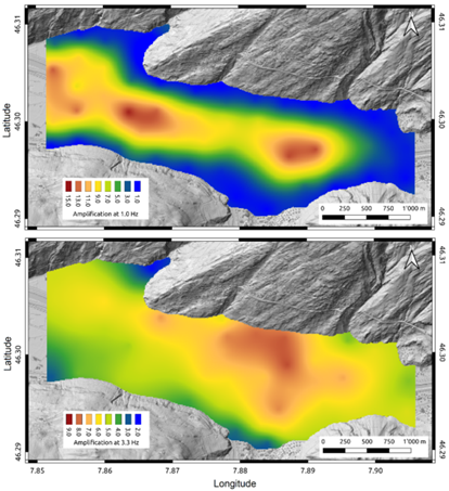
Elaboration of elastic response spectra for alpine valleys as a basis for a further development of the SIA 261 building standard
|
|
Settlements only few hundred meters apart can be affected at significantly different levels by the same earthquake. The cause is the local earthquake response, or site amplification, which is determined by the type of soil (e.g. soft sediments or stiff rock) but also by its geometry (a wide plain or a sedimentary basin). In this perspective, the alpine valleys are peculiar geological environments, as the thickness of the sedimentary infill increase from few meters at the borders of the valley to several hundred meters at its centre; this setting determines distinctive earthquake response effects. Besides, valleys are not marginal from the risk point of view, as they can be densely populated and host critical infrastructure for the transport of goods and people across the alpine arch. |
|---|---|
| Project Leader at SED | Donat Fäh |
| SED Project Members | Paolo Bergamo, Dario Chieppa |
| Funding Source | FOEN (Federal Office for the Environment) |
| Duration | 2021 - 2024 |
| Keywords | Earthquake site response, alpine valleys, building codes |
| Research Field | Engineering seismology |
| Publications |
Arbeitsgruppe Erdbeben der Normenkommission SIA 261 (2019). Aktualisierung der Erdbebeneinwirkungen der Norm SIA 261:2014 . Bericht z.H. der Normkommission SIA 261 und der Kommission für technische Normen (KTN) Referenz/Aktenzeichen: S041-0132. In: Bundesamt für Umwelt BAFU Abteilung Gefahrenprävention, 26.03.2019. BAFU (2020). Erdbebenrisikomanagement - Massnahmen des Bundes. Bericht an den Bundesrat. Standbericht und Planung für den Zeitraum 2021 bis 2024. Bundesamt für Umwelt, Dezember 2020. |
Numerical Modeling
Ground Motion Prediction Equations (GMPEs)
|
This is the 1st subproject of the “ENSI – SED-Erdbebenforschung zu Schweizer Kernanlagen” project. This subproject aims to improve source-scaling and attenuation models and to develop methods for the prediction of strong ground motion in Switzerland both at the surface as well as at depth. Two main approaches are investigated: ground motion prediction equations (GMPEs) and stochastic simulation models. Both approaches require adaptions to the local seismicity and careful consideration of their calibration to Swiss conditions. The Fourier spectral and stochastic models correspond to the current state of research and have some advantages over the empirical attenuation relationships, as it is possible to adjust the model to specific local site conditions. The complete understanding in terms of physical parameterization of such models is crucial in order to decouple different effects, which allow building robust predictive models that scale appropriately to large magnitude events. In this regard, variability in source parameter such as stress drop and corner frequency is crucial. Similarly, variability in site-related attenuation parameter kappa (local intrinsic and scattering attenuation) is also need to be well understood. Developed stochastic and duration models from Japanese data allow the review of the Swiss model for large magnitudes in the different distance ranges and at various rock sites which have, as yet, not been instrumentally recorded in Switzerland. The local weak-to-moderate seismicity is used to calibrate the predictive models. The long-term goal is to develop an improved stochastic simulation model for Switzerland allowing existing uncertainties to be rigorously evaluated and reduced. In future, such models will also allow an assessment of ground motion caused by induced seismicity due to the activation of existing fractures and/or the generation of new fractures. Moreover, we developed, validated, and applied a physics-based stochastic model to characterize high-frequency ground motion at depth in the Fourier domain. The goal of it is to be able to predict future ground motions at deep geological disposals. |
|---|---|
| Project Leader at SED | Prof. Donat Fäh |
| SED Project Members | Miroslav Hallo, Paolo Bergamo |
| Funding Source | Swiss Federal Nuclear Safety Inspectorate - ENSI |
| Duration | 2014-2026 |
| Keywords | Ground motion prediction equations, Fourier spectral models, stochastic ground motion models, ground motion duration models. |
| Research Field | Earthquake Hazard & Risk, Engineering Seismology |
| Publications |
Hallo, M., Bergamo, P., and Fäh, D. (2022). Stochastic model to characterize high-frequency ground motion at depth validated by KiK-net vertical array data. Bulletin of the Seismological Society of America (under review).. Bard, P.-Y., Bora, S. S., Hollender, F., Laurendeau, A., and Traversa, P. (2020). Are the standard VS-Kappa host-to-harget adjustments the only way to get consistent hard-rock ground motion prediction?. Pure and Applied Geophysics 177, 2049–2068. doi: 10.1007/s00024-019-02173-9 Edwards, B., and Fäh, D. (2017). Prediction of earthquake ground motion at rock sites in Japan: evaluation of empirical and stochastic approaches for the PEGASOS Refinement Project. Geophysical Journal International 211(2), 766-783. doi: 10.1093/gji/ggx328 Pilz, M., and Fäh, D. (2017). The contribution of scattering to near-surface attenuation. Journal of Seismology 21 (4), 837–855. doi: 10.1007/s10950-017-9638-4 Edwards, B., Cauzzi, C., Danciu, L., and Fäh, D. (2016). Region-specific assessment, adjustment, and weighting of ground-motion prediction models: Application to the 2015 Swiss seismic-hazard maps. Bulletin of the Seismological Society of America 106 (4), 1840-1857. doi: 10.1785/0120150367 Edwards, B., Ktenidou, O.-J., Cotton, F., Abrahamson, N., Van Houtte, C. and Fäh, D. (2015). Epistemic uncertainty and limitations of the Kappa0 model for near-surface attenuation at hard rock sites. Geophysical Journal International 202 (3), 1627-1645. doi: 10.1093/gji/ggv222 Edwards, B. & Fäh, D. (2014). Ground motion prediction equations. Link doi: 10.3929/ethz-a-010232326 Edwards, B. and Fäh D. (2013). A Stochastic Ground‐Motion Model for Switzerland. Bulletin of the Seismological Society of America 103, 78-98. doi: 10.1785/0120110331 Edwards, B., Michel, C., Poggi, V. and Fäh, D. (2013). Determination of Site Amplification from Regional Seismicity: Application to the Swiss National Seismic Networks. Seism. Res. Lett. 84(4), 611-621. doi: 10.1785/0220120176 Poggi, V., Edwards, B. and Fäh, D (2013). Reference S-wave velocity profile and attenuation models for ground-motion prediction equations: application to Japan. Bulletin of the Seismological Society of America 103(5), 2645-2656. doi: 10.1785/0120120362 Poggi, V., Edwards, B. and Fäh, D. (2012). Characterizing the vertical to horizontal ratio of ground-motion at soft sediment sites. Bulletin of the Seismological Society of America 102(6), 2741-2756. doi: 10.1785/0120120039 Poggi, V., Edwards, B. and Fäh, D. (2011). Derivation of a Reference Shear-Wave Velocity Model from Empirical Site Amplification. Bulletin of the Seismological Society of America 101(1), 258-274. doi: 10.1785/0120100060 |
Strong Motion Seismology
Seismotectonics
Earthquake-induced Phenomena
Seismic monitoring of the rock instability at the former Mitholz ammunition depot
|
There is a higher risk of explosion from ammunition ordnance in the former Mitholz ammunition depot than previously assumed. For this reason, it was decided to completely clear the site. The results published in the work by Glueer et al. (2021) show that a possible earthquake-induced rockfall should be taken into account in risk assessments. Large amplifications of seismic waves are observed on the rock mass above the cavern at Mitholz, the origin of which is the strong internal disruption of the rock mass due to the explosions in 1947. The Federal Department of Defence, Civil Protection and Sport (DDPS) and ETH Zurich are therefore conducting a joint seismological research and measurement project. This includes an alarming after an earthquake, the installation of permanent and temporary seismic sensors and the development of a 3D model of the underground.
To optimise the positioning of the permanent seismic stations, ambient vibration measurements are carried out over the entire rock formation above the caverns using dense arrays of seismic sensors. The aim of the measurements is to map the natural frequencies and polarisation of the wave field as a whole. We use the scientific methods developed at the SED, and thus to obtain information about the internal structure of the rock mass, particularly regarding the potential disruption of the material at the rock front and deep fracture structures that delimit the large volumes. These investigations are combined with engineering-geological studies. They lead to the development of a three-dimensional model, which is used for modelling earthquake effects. |
|---|---|
| Project Leader at SED | Prof. Donat Fäh |
| SED Project Members | Franziska Glüer, Mauro Häusler, Xavier Borgeat, Valentin Gischig |
| Funding Source | Eidgenössische Departement für Verteidigung, Bevölkerungsschutz und Sport (VBS) |
| Duration | 2024-2025 |
| Keywords | Earthquake induced mass movements, unstable rock-slopes, real-time monitoring, seismic methods |
| Research Field | Earthquake Hazard and Risk, Geo Risks |
| Publications |
Glueer, F., Häusler, M., Gischig, V. and Fäh, D. (2021). Coseismic Stability Assessment of a Damaged Underground Ammunition Storage Chamber Through Ambient Vibration Recordings and Numerical Modelling. Front. Earth Sci. https://doi.org/10.3389/feart.2021.773155 Häusler, M., Glueer, F., & Fäh, D. (2024). The changing seismic site response of the Brienz/Brinzauls rock slope instability: insights from 5 years of monitoring before, during and after a partial collapse in June 2023. ICL open access book series “Progress in Landslide Research and Technology” 2-12. Burjanek, J., Kleinbrod, U., & Fäh, D. (2019). Modeling the Seismic Response of Unstable Rock Mass With Deep Compliant Fractures. Journal of Geophysical Research-Solid Earth 124(12), 13039-13059. doi: 10.1029/2019jb018607 Häusler, M., Michel, C., Burjanek, J., & Fäh, D. (2019). Fracture Network Imaging on Rock Slope Instabilities Using Resonance Mode Analysis. Geophysical Research Letters 46(12), 6497-6506. doi: 10.1029/2019gl083201 Häusler, M., Gischig, V., Thöny, R., Glueer, F. and Fäh, D. (2021). Monitoring the changing seismic site response of a fast-moving rockslide (Brienz/Brinzauls, Switzerland). Geophysical Journal International 229 (1), 299-310. doi: 10.1093/gji/ggab473 Kleinbrod, U., Burjanek, J., & Fäh, D. (2019). Ambient vibration classification of unstable rock slopes: A systematic approach. Engineering Geology 249, 198-217. doi: 10.1016/j.enggeo.2018.12.012 |