Press tab to activate screen reader mode
  • Home
  • Language
  • Navigation menu
  • Search
  • Plain language
  • Content
  • Contact
MENU
Swiss Seismological Service logo ETH logo
DE EN FR IT
Plain language
DE EN FR IT
×
  • Home
  • Earthquakes
    • Switzerland
    • Europe
    • World
    • Maps
    • Report an earthquake
    • What to do?
      • Behavioural recommendations
      • Earthquakes abroad
      • Earthquake-resistant construction
      • Earthquake insurance
    • Always informed
      • Alerting
      • Receive information
      • Rapid impact assessment
      • ShakeMap
      • Earthquake announcements
  • Monitoring
    • Measuring earthquakes
    • National seismic network
    • Special networks
      • Overview
      • Geothermal Haute-Sorne
      • Geothermal Yverdon-les-Bains
      • Geothermal Geneva Basin
      • Geothermal Vinzel
      • Geological repository Northeastern Switzerland
      • Borehole Basel
      • Past projects
    • Realtime seismograms
      • Last 5 minutes
      • Last 20 minutes
      • Last 2 hours
      • Last 24 hours
    • Setup of a monitoring station
    • Nuclear test ban treaty monitoring
  • Earthquake country Switzerland
    • Overview
    • Hazard
      • Overview
      • Components
      • Earthquake hazard model
    • Risk
      • Overview
      • Components
      • Earthquake risk model
      • Earthquake risk tool
    • Earthquake scenarios
    • Earthquake regions
      • Grisons
      • Valais
      • Basel
    • Historical earthquakes
      • The ten strongest
      • Basel 1356
      • Sierre 1946
    • Earthquake swarms
      • Introduction
      • Sarnen 1964
      • Diemtigen 2014 - 2015
  • Knowledge
    • Causes of earthquakes
      • In general
      • In Switzerland
      • In Europe
      • Induced earthquakes
    • Effects of earthquakes
    • Earthquake prediction
    • Earthquake data & web portals
      • Overview
      • Earthquake monitoring software
      • Station information
      • Earthquake catalogues
      • Waveform data
      • FDSN web services
      • Earthquake early warning
      • ShakeMap
      • Software archive
    • Geothermal energy & earthquakes
      • Geothermal energy in brief
      • Forms of geothermal energy
      • Geothermal energy & induced earthquakes
      • Measures to control induced seismicity
      • Geothermal energy in Switzerland
      • Geothermal energy and the SED
      • Seismological consulting (GEOBEST2020+)
      • Fracking
    • Quakes on Mars
    • Frequently asked questions (FAQ)
  • Research & teaching
    • Projects
    • Publications
    • Teaching & training
    • Schatzalp Workshop 2025
  • News & services
    • News articles
      • 2025
      • 2024
      • Archive
    • For schools
    • Brochures
    • Quiz
    • Videos & games
    • Earthquake simulator
    • Earthquake literature
  • About us
    • Contact & media enquires
    • Portrait
      • Tasks & organisation
      • History
      • Independence & transparency
    • Sections
    • All employees
    • Careers
    • Cooperations
    • Intranet
The content of the page starts here

2025

Picture for Felt earthquake east of Herisau (AR)

2025-12-06

Felt earthquake east of Herisau (AR)

Saturday, December 6 at 00:55h (local time) an earthquake with a magnitude of 2.9 took place east of Herisau (AR) at a depth of 6-7km. It was felt predominantly in an area up to 15 km from the epicenter. 

Earthquakes of this magnitude typically don't cause damage; they are not exceptional in this region of Switzerland.


Go to page
Picture for Confederation updates natural hazards portal

2025-11-20

Confederation updates natural hazards portal

For more than ten years, the Confederation's natural hazards portal (www.natural-hazards.ch) has provided the public with information on the current natural hazard situation in Switzerland. To ensure that the portal continues to meet users’ needs in the future, the federal agencies with responsibility for natural hazards have revised it: warnings and notifications, as well as information on ...
Go to page
© Kontrollstelle für Chemie- und Biosicherheit

2025-10-22

Understanding the earthquake risk in the canton of Basel-Stadt

The strongest known earthquake north of the Alps occurred near Basel in 1356. Even today, the Basel region is considered to be at higher seismic risk than other areas of Switzerland. But what would happen in the event of the next major earthquake? The regional earthquake risk model developed by the Swiss Seismological Service at ETH Zurich, in collaboration with EPFL, the University of Basel, and the company Résonance, provides answers to this question on behalf of the canton of Basel-Stadt. ...
Go to page
© WSS, Foto: Felix Wey, Baden

2025-09-12

Observing earthquakes where they occur

To study how earthquakes initiate, propagate and stop, a new side tunnel has been built at the BedrettoLab at ETH Zurich. It serves as an observation centre for a fault and is equipped with numerous sensors and instruments, a facility that is unique in the world. The Swiss Seismological Service (SED) at ETH Zurich is involved in both research and monitoring of seismic activity. ...
Go to page
Picture for [Available in DE/IT] Spürbares Erdbeben östlich von Scuol (GR)

2025-09-02

[Available in DE/IT] Spürbares Erdbeben östlich von Scuol (GR)

Am Dienstag, dem 02. September 2025, hat sich um 09:49 Uhr (Lokalzeit) bei Mals/Malles Venosta (IT) im Vinschgau östlich von Scuol (GR) in einer Tiefe von ungefähr 8 bis 10 Kilometern ein Erdbeben der Magnitude 3.8 ereignet. Die Erschütterungen des Bebens waren im Val Müstair und im Unterengadin – in Sent, Scuol bis nach Davos – zu spüren. Bei einem Erdbeben dieser Stärke und in dieser Tiefe sind in der Regel keine Schäden zu erwarten. ...
Go to page
Picture for [Available in DE] Erdbeben nördlich von Affoltern am Albis (ZH)

2025-07-30

[Available in DE] Erdbeben nördlich von Affoltern am Albis (ZH)

Am Mittwoch, dem 30. Juli, ereignete sich um 03:42 Uhr Lokalzeit nördlich von Affoltern am Albis (ZH) ein Erdbeben der Magnitude 3.1. Das Hypozentrum lag in einer Tiefe von etwa 6 Kilometern. Das Beben wurde deutlich gespürt, insbesondere im Umkreis von rund 10 Kilometern um das Epizentrum. Innerhalb der ersten Stunde nach dem Ereignis gingen beim Schweizerischen Erdbebendienst (SED) knapp 90 Verspürtmeldungen ein. ...
Go to page
Picture for [Available in DE / FR] Erdbeben nördlich von Rheinfelden (AG)

2025-07-28

[Available in DE / FR] Erdbeben nördlich von Rheinfelden (AG)

Am Montag, dem 28. Juli, ereignete sich um 15:48 Uhr Lokalzeit nördlich von Rheinfelden (AG) ein Erdbeben der Magnitude 3.1. Das Hypozentrum lag in einer Tiefe von etwa 7 Kilometern unter dem Dinkelberg im Südschwarzwald (D). Das Beben wurde deutlich gespürt, insbesondere im Umkreis von rund 20 Kilometern um das Epizentrum. Innerhalb der ersten Stunde nach dem Ereignis gingen beim Schweizerischen Erdbebendienst (SED) knapp 100 Verspürtmeldungen ein. ...
Go to page
Picture for [Available in DE, FR] Mittelstarkes Erdbeben bei Mürren (BE)

2025-07-21

[Available in DE, FR] Mittelstarkes Erdbeben bei Mürren (BE)

Am Montag, den 21. Juli, hat sich um 12:52 Uhr Lokalzeit, bei Mürren (BE) im Berner Oberland, in einer Tiefe von ungefähr 1 km unter der Erdoberfläche, ein Erdbeben mit einer Magnitude von 4.2 ereignet. Das Beben wurde weiträumig verspürt, vor allem in Nord-Süd Richtung bis Basel und Sitten. In der ersten halben Stunde nach dem Beben sind beim Schweizerischen Erdbebendienst (SED) mehr als 350 Verspürtmeldungen eingegangen. ...
Go to page
When glaciers melt and permafrost thaws, meltwater finds new pathways into the deep underground. Shallow earthquakes are related to runoff from the previous year, and deeper earthquakes to runoff from the year before that.

2025-07-02

Glacier melt increases seismic activity under the Mont Blanc Massif

There have been repeated small earthquakes under and around the Mont Blanc Massif for around ten years now. A new study demonstrates for the first time a link between climate-driven changes in glaciated high mountain regions and increased local earthquake hazard. ...
Go to page
Picture for SED monitoring test stimulations for Haute-Sorne geothermal project (canton of Jura)

2025-06-16

SED monitoring test stimulations for Haute-Sorne geothermal project (canton of Jura)

On Friday, 13 June, the canton of Jura granted approval for test stimulations as part of the geothermal project in Haute-Sorne (JU). These tests will involve forcing pressurised water into the geological underground through the exploratory borehole which was drilled in summer 2024. The water will emerge around four kilometres below the surface before filtering into the adjacent rock. ...
Go to page
Picture for [Available in DE/FR] Seismisches Netzwerk zeichnet Gletscherabbruch am Kleinen Nesthorn auf

2025-05-28

[Available in DE/FR] Seismisches Netzwerk zeichnet Gletscherabbruch am Kleinen Nesthorn auf

Der Gletscherabbruch am Kleinen Nesthorn (VS) am Mittwoch, dem 28. Mai 2025, wurde landesweit vom seismischen Netzwerk der Schweiz registriert. Es handelt sich dabei um eine der grössten Massenbewegungen, die der Schweizerische Erdbebendienst (SED) an der ETH Zürich bislang aufgezeichnet hat. ...
Go to page
Picture for Earthquake south-east of Mürren (BE)

2025-05-04

Earthquake south-east of Mürren (BE)

On Sunday, May 4 at 13:30, an earthquake with a magnitude of 3.1 occurred near Mürren, close to Lauterbrunnen (BE). It was registered at a depth of 7.6 km. The earthquake was felt in the immediate vicinity. ...
Go to page
Picture for Schatzalp Workshop on Induced Seismicity

2025-04-22

Schatzalp Workshop on Induced Seismicity

Understanding and managing induced seismicity remains a key challenge for geothermal and other deep underground projects. In March, over 160 international experts from research and industry met to discuss current and future challenges in areas ranging from modelling, risk assessment, response ...
Go to page
For all 43 seismic nodes deployed on the lake ice, the project team carefully installed the sensors then attached them to small poles for security. The ice thickness was also directly measured using a large drill.

2025-04-02

Recording icequakes on Lake St. Moritz

For the third winter in the past five years, the Swiss Seismological Service (SED) and the Institute of Geophysics (IfG) at ETH Zurich have recorded icequakes on the frozen Lake St. Moritz. ...
Go to page
ShakeMap USGS (https://earthquake.usgs.gov/)

2025-03-28

Devastating earthquake in Myanmar

On 28 March at 12.50 local time (07.20 Swiss time), a 7.7 magnitude earthquake struck Myanmar at a depth of approximately 10 to 20 kilometres, about 20 kilometres west of the city of Mandalay. ...
Go to page
Picture for Earthquake activity in 2024

2025-01-30

Earthquake activity in 2024

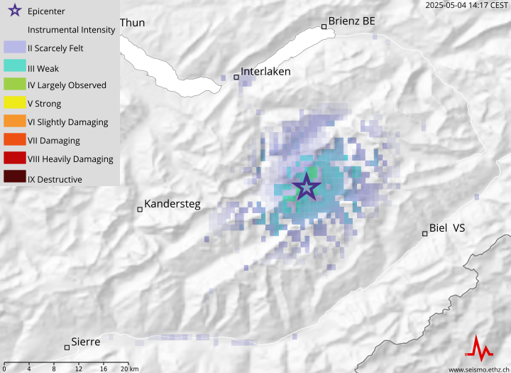
2024 was a record year: there were some 2,300 recorded earthquakes in Switzerland and neighbouring regions, substantially more than the previous annual high of 1,660 earthquakes in 2019. There are many factors behind this record, which are not yet fully understood. ...
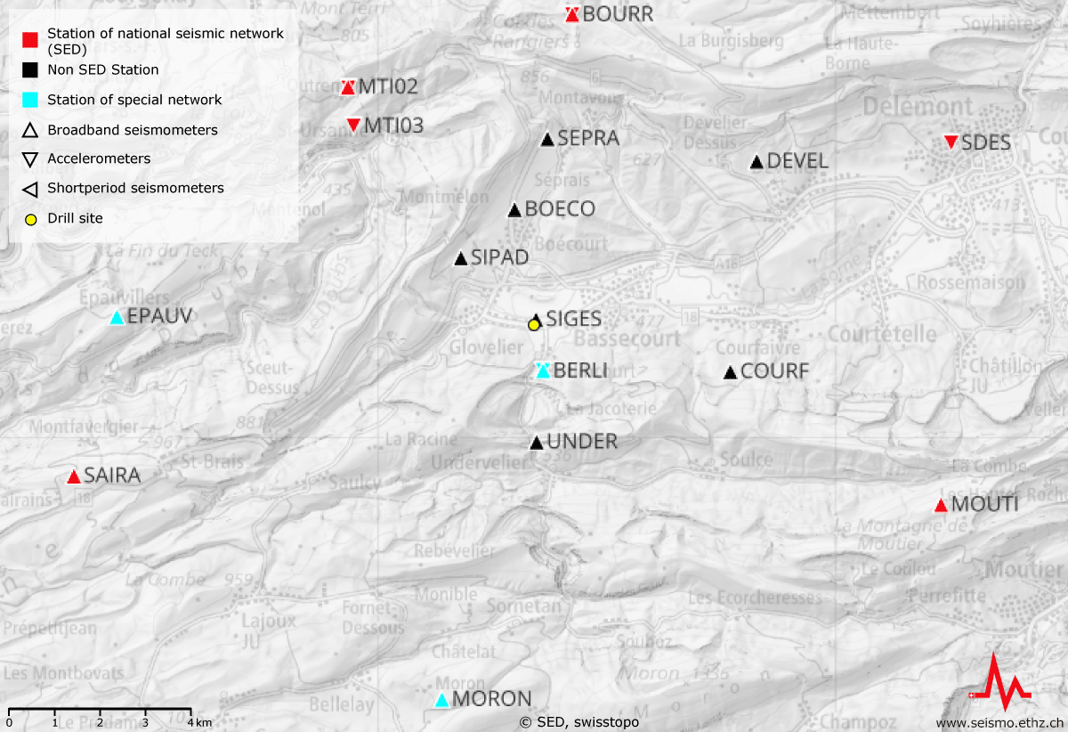
Go to page

Swiss Seismological Service
Sonneggstrasse 5
CH-8092 Zurich
Phone SED secretariat
+41 44 633 21 79 (during office hours)

Imprint  |  Disclaimer  |  Data Protection  |  ©2025 ETH Zurich