New image with text
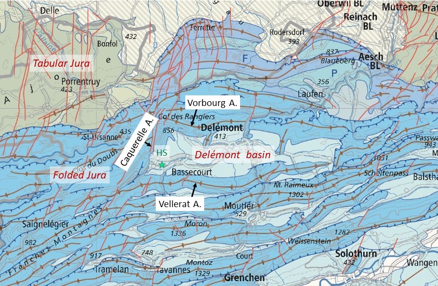
The municipality of Haute-Sorne is situated in the Delémont Basin, where the southern end of the Upper Rhine Graben meets the northern Folded Jura. The Jura Mountains are a typical fold-and-thrust belt that formed during the Late Miocene and Early Pliocene as a result of the Alpine mountain-building process. The Delémont Basin is a Jura syncline filled with a sedimentary sequence representing the northern edge of the Molasse, the so-called Jura Molasse. This sedimentary sequence once covered a significant portion of the present-day Jura chain during the Oligo-Miocene period. Today, only a few remnants of the Jura Molasse are preserved in the Jura synclines, with the largest in the Delémont basin.
The western basin is surrounded by three anticlines: Vorbourg in the north, Vellerat in the south, and Caquerelle in the west. The Caquerelle anticline's NNE orientation suggests the existence of an inherited normal fault in the crystalline basement, which developed during the Paleogene intra-continental rifting phase, long before the formation of the Alps (Laubscher 1963). The basin itself is divided into three sections by two NNE-oriented transverse faults: the Develier fault in the west and the Vicques fault in the east (Suter, 1978).
Compared to other parts of Switzerland, the region of Haute-Sorne shows an intermediate seismic hazard. Seismic risk is amplified in the Delémont Basin by the presence of predominantly soft soils. The strongest earthquake that occurred in the canton in the last 100 years is the magnitude 4.3 Réclère event that shook the Ajoie in March 2023. This event and the sequence to which it belongs occurred about 23 kilometers from the geothermal project site. Historically, a magnitude 4.7 earthquake hit the Sundgau region (Altkrich, F) in 1784. However, the most destructive event for the region of canton Jura was clearly the 1356 magnitude 6.6 earthquake that occurred close to Basel. On statistical average, an earthquake of magnitude 6.0 is to be expected once every 2300 years in a radius of 30 km around the Haute-Sorne project, which encompasses the cantonal territory. For magnitudes 5.0 and 4.0 these return periods are 325 years and 45 years, respectively.